Balbharti Maharashtra State Board Class 11 Economics Solutions Chapter 10 Economic Planning in India Textbook Exercise Questions and Answers.
Maharashtra State Board Class 11 Economics Solutions Chapter 10 Economic Planning in India
1. Choose the correct option:
Questions 1.
Statements that are true about the Planning Commission:
(a) Planning Commission was established in 1950.
(b) The Prime Minister is the Ex-Officio Chairman of the Planning Commission.
(c) Economic planning is a time-bound program.
(d) Economic planning is based on predetermined objectives.
Options:
(1) a and b
(2) a, b, c, and d
(3) a and c
(4) None of these
Answer:
(1) a and b
![]()
Question 2.
Statements that are incorrect regarding India’s five-year plans:
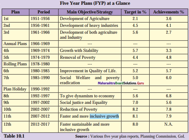
(a) The main objective of the first five-year plan was the development of agriculture.
(b) Social welfare and poverty eradication were the prime objectives of the seventh five-year plan.
(c) By the second five-year plan, focus increased on faster, inclusive growth.
(d) Development of both agriculture and industry were the main objectives of the third five-year plan.
Options:
(1) a
(2) a, b and d
(3) c
(4) b and d
Answer:
(3) c
Question 3.
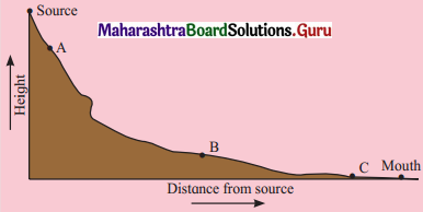
| Group – ‘A’ | Group – ‘B’ |
| 1. Economic planning | (a) Selection by Prime Minister |
| 2. Twelfth Five Year Plan | (b) Think Tank group of Indian Government |
| 3. NITI Aayog | (c) Fast and sustainable growth |
| 4. NITI Aayog Vice-Chairperson | (d) Time-bound programme |
Options:
(1) 1 – c, 2 – a, 3 – d, 4 – b
(2) 1 – d, 2 – b, 3 – a, 4 – c
(3) 1 – d, 2 – c, 3 – b, 4 – a
(4) 1 – b, 2 – d, 3 – c, 4 – a
Answer:
Correct pair: (3) 1 – d, 2 – c, 3 – b, 4 – a
Question 4.
Choose the correct statement:
Statement 1 – NITI Aayog takes note of the dynamic change in the Indian economy.
Statement 2 – Considering the economic, social, and technological differences in underdeveloped districts, the body plans to implement various programmes and bring about economic changes.
Options:
(a) statement 1 is correct
(b) statement 2 is correct
(c) statement 2 is the result of statement 1
(d) there is no relation between statement 1 and statement 2.
Answer:
(c) statement 2 is the result of statement 1
2. Give economic terms:
Question 1.
The conscious and deliberate choice of economic priorities by some public authority.
Answer:
National Agenda
![]()
Question 2.
A group of people called forth by the government to discuss various problems and also try to find solutions to them.
Answer:
Think Tank
3. Identify and explain the concepts from the given illustrations:
Question 1.
Sayali’s mother maintains a book of accounts for household purposes and plans the expenditure accordingly.
Answer:
Planning.
It is a time-bound programme. The objectives should fulfill by using available resources within the time limit.
Question 2.
Ramabai gets a subsidy on domestic LPG directly transferred to her bank a/c.
Answer:
Service Delivery.
It is the important target of the 12th five-year plan. The main aim behind this policy is to prevent corruption.
Question 3.
To solve classroom-related issues, the teacher forms a group of students. This group discusses the problems and finds solutions to them.
Answer:
Think-Tank
- It is important to function of NITI Aayog to solve the problems of our country.
- Think-Tank is a group of experts who are discussing and solve various problems of India.
4. Answer the following:
Question 1.
Explain the features of economic planning.
Answer:
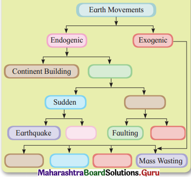
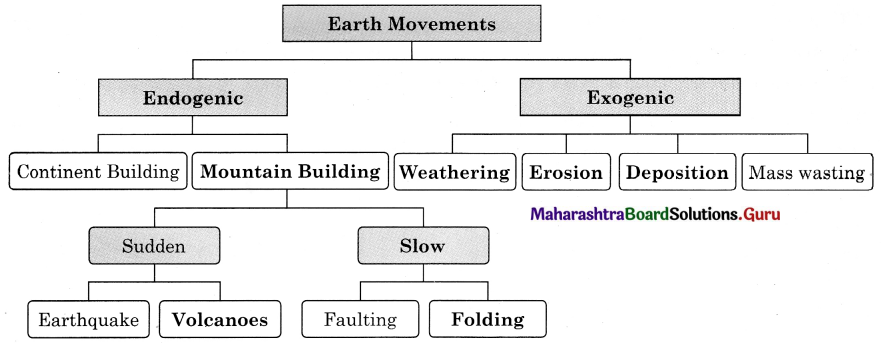
Economic planning is a time-bound programme to achieve certain objectives by allocating available resources under the control of a central planning authority.
Prof. H. D. Dickinson defines economic planning as – “Economic planning is the making of major economic decisions such as what and how much is to be produced how, when and where it is to be produced, to whom it is to be allocated, by the conscious decision of the determinate authority, on the basis of a comprehensive survey of the economy as a whole.”
On the basis of the above definition, its main characteristics are:
- Central Planning Authority (CPA): There is a central planning authority that formulates the plans. In India, this authority is known as Planning Commission.
- Survey: There is a complete survey of the economy regarding the availability and use of natural and human resources.
- Objectives: It lays down certain objectives which are realistic and flexible.
- Priorities: Priorities are fixed according to the importance of each sector for its development.
- Mobilization of resources: Resources are mobilised through various sources like taxation, deficit financing, savings, etc.
- Plan period: Each plan is for a specific period, usually five years.
- Evaluation: From time to time, an assessment of the plan objectives is done to make changes if necessary.
- Continuous process: Economic planning is a continuous process which aims at the economic development of a country.
- Co-ordination: In India, economic planning is implemented by the Centre and State Governments together.
- Flexibility: There is flexibility in India’s economic planning so it’s possible to make changes as per the need.
![]()
Question 2.
Explain the targets of the 12th Five Year plan.
Answer:
Targets for infrastructure are:
- To connect all villages of a country with all-weather roads.
- To increase rural television and telephone density to 70%.
- To increase infrastructure investment to 9% of G.D.P.
- To upgrade national and state highways to a minimum two-lane standard.
- To achieve real GDP growth rate at 8%, agriculture growth rate at 4%, and manufacturing and industrial growth rate at 10 %.
- To reduce the headcount ratio of poverty by 10%.
- To create 50 million (5 crores) new work opportunities in the non-farm sector.
- To increase average years of schooling to 7 years.
- To eliminate gender and social gap in school enrollment.
- To reduce the total fertility rate to 2.1%.
Question 3.
Explain the structure of NITI Aayog.
Answer:
The structure of NITI Aayog includes Governing Council, Regional Councils, Special Invitees, and Organisational Framework. The organizational framework includes Chairperson, Vice-Chairperson, Ex-officio members, CEO, and Secretariat.
Question 4.
Explain the functions of NITI Aayog.
Answer:
Functions of NITI Aayog:
- To evolve a shared vision of national development, priority sector, and strategies with the active involvement of states in the light of national objectives.
- To act as ‘Best Friend at the Centre’.
- To formulate plans at the village level and aggregate higher levels of government.
- To provide feedback for constant innovative improvements.
- To provide advice and encourage partnership with national and international Think-Tank.
- To create a knowledge, innovation, and entrepreneurial support system.
- To offer a platform for the resolution of inter-sectoral and inter-departmental issues.
- To maintain a state-of-the-art resource center for research on good governance.
- To focus on technology up-gradation and capacity building.
- To foster Cooperative federalism, with the active involvement of states.
Question 5.
Distinguish between Planning Commission and NITI Aayog.
Answer:
| NITI Aayog | Planning Commission |
| (i) It serves as an advisory Think Tank. | (i) It served as the extra-constitutional body. |
| (ii) It draws membership from wider expertise. | (ii) It had limited expertise. |
| (iii) It serves in the spirit of cooperative federalism as states are equal partners. | (iii) States participated as spectators in the annual plan meetings. |
| (iv) Secretaries to be known as CEO appointed by Prime Minister. | (iv) Secretaries were appointed through the usual process. |
| (v) It focuses upon the Bottom-up approach. | (v) It followed a Top-down approach. |
| (vi) It does not process mandate to impose policies. | (vi) It imposed policies on states and tied allocation of funds with projects it approved. |
| (vii) It does not have powers to allocate funds, which are vested in the finance minister. | (vii) It had powers to allocate funds to ministers and state government. |
| (viii) It was established on 1st January 2015. | (viii) It was established on 15th March 1950. |
5. State with reasons whether you agree or disagree with the following statements:
Question 1.
State governments have a more significant role to play under NITI Aayog.
Answer:
Yes, I do agree with the statement.
- Under the planning commission, there was a one-way flow of policy i.e. from, Central Government to State Government.
- In NITI Aayog, the flow of policy is from Central Government to State Government and State Government to Central Government between ministers.
- In the policy-making of the Central Government, State Government will work closely with the center.
- Governing Council of NITI Aayog consists of all Chief Ministers of the States.
- Thus, State Government has a more significant role to play under NITI Aayog.
![]()
Question 2.
Functions of the Planning Commission have been transferred to NITI Aayog.
Answer:
Yes, I do agree with the statement.
- The planning commission enjoyed the powers to allocate funds to ministry and state government.
- NITI Aayog/Think Tank is an advisory body that performs the function of allocation of funds.
- On 31st January 2015, Planning Commission was replaced by NITI Aayog for making policies and to implement them.
- NITI Aayog aimed at expanding the role of the states, making the role of the state stronger in collaboration with the center.
Question 3.
The objective of the 12th five-year plan was to achieve faster, sustainable and inclusive growth.
Answer:
Yes, I do agree with the statement.
- 12th five-year plan aims at a GDP growth rate of 8%.
- It seeks to achieve 4% growth in the agriculture sector.
- If aimed to generate 50 million work opportunities in the non-farm sector and providing skill certification.
- Connecting all the villages of the country with all-weather roads.
- Increasing green cover by 1 million hectares every year.
- These objectives will help the country to achieve faster, sustainable and inclusive growth.
6. Read the following passage and answer the questions given below:
The Finance Minister of the Central Government presents the Union Budget before the Parliament during the month of February every year. The budget, also referred to as the annual financial statement reflects the estimated receipts and expenditure of the government for a particular financial year that begins on the 1st of April and ends on 31 sc March. Changes in the tax structure are suggested in the budget. Besides this, provisions are also made for allocating expenditure on defense, education, research, and development, etc. The date for presenting the budget has been shifted to the 1st of February every year. This enables the generation of funds well in advance prior to the commencement of the financial year.
Question 1.
Where is the Union Budget usually presented?
Answer:
Union Budget is presented in the Parliament.
Question 2.
What all aspects are considered while preparing the budget?
Answer:
Changes in the tax structure, provisions for allocating expenditure on defense, education, research, and development.
![]()
Question 3.
Why is the date for presenting the budget shifted to the 1st of February?
Answer:
The date for presenting the budget is shifted to the 1st of February because it enables the generation of funds well in advance prior to the commencement of the financial year.
Question 4.
Explain the term ‘budget’.
Answer:
A budget is the annual financial statement that shows estimated receipts and expenditures of the government for a year.
11th Economics Digest Chapter 10 Economic Planning in India Intext Questions and Answers
Collect information on: (Textbook Page No. 64)
- Bombay Plan
- People’s Plan
- Gandhian Plan
Answer:
- Bombay Plan: It is the name given to a World War II era. It is a set of proposals for the development of the post-independence economy of India.
- Peoples Plan: It is to provide satisfaction to the immediate basic needs of India within a period of ten years.
- Gandhian Plan: Espousing with the spirit of Gandhian economic thinking, Shriman Narayan Agarwal formulated this plan in 1944. This plan laid more emphasis on agriculture.
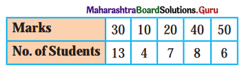
Find out: (Textbook PageNo. 65 )
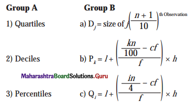
Calculate D6 and D9 from the above table using ‘achievements’ as the numerical data.
Answer:

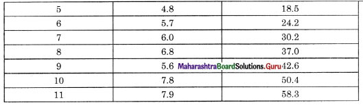
(i) Sixth Decile:
D6 = size of 6 \(\left(\frac{n+1}{10}\right)^{t h}\) Observation
= size of 6 \(\left(\frac{11+1}{10}\right)^{t h}\) Observation
= size of 6 \(\left(\frac{12}{10}\right)^{t h}\) Observation
= size of 6 (1.2)th Observation
= size of (7.2)th Observation
size of 7.2 th 0bservation lies in of 7.7
∴ D6 = 2
![]()
(ii) Ninth Decile:
D9 = size of 9 \(\left(\frac{n+1}{10}\right)^{t h}\) Observation
= size of 9 \(\left(\frac{11+1}{10}\right)^{t h}\) Observation
= size of 9 \(\left(\frac{12}{10}\right)^{t h}\) Observation
= size of 9 (1.2)th Observation
= size of 10.8th Observation
size of 10.8 th 0bservation lies in of 13.7.
∴ D9 = 4
Find out: (Textbook Page No. 66)
Information of various levels of National Family Health Survey (NFHS).
Answer:
- NFHS – 1: The first NFHS was conducted in 1992-93. The survey collected extensive information on population, health, and nutrition, with an emphasis on women and children.
- NFHS – 2: The second NFHS was conducted in 1998-99 in all states (26) of India. It was on the quality of health and family planning services, domestic violence, reproductive health, anemia, etc.
- NFHS – 3: The third NFHS was conducted in 2005-06, in 29 states of India. UNICEF, USAID, DFID, USA, providing funds and technical help for NFHS-3.
- NFHS – 4: The fourth NFHS was conducted in 2014-2015. USA was a major financial supporter for NFHS-4. It was conducted in 29 states and 6 union territories and focused on 640 districts in the country.
Do you know? (Textbook Page No. 66)
Think-tank: Think-tank is a group of experts who are gathered together by an organization, especially by a Government in order to consider various problems, try and work out ways to solve them.
Answer:
- ‘Think-Tank’ is a group of experts who come together, to form an organization.
- They study the various problems of an economy and try to bring solutions to solve those problems.
- It is counted under the premier policy of the Government of India.
- Its main objective is to find a shared vision of national development with the active participation of the states.
- It provides guidance to foster ‘cooperative federalism in the states.
![]()
Find out: (Textbook Page No. 67)
The present structure of NITI Aayog and list out the names of members in the respective columns.
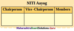
Answer:
| Chairperson | Vice-Chairperson | Members |
| Prime Minister | Rajiv Kumar | Ex-Officio Members, Special Invitees, Full-time Members |