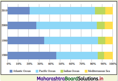
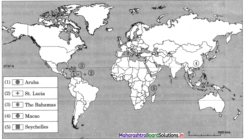
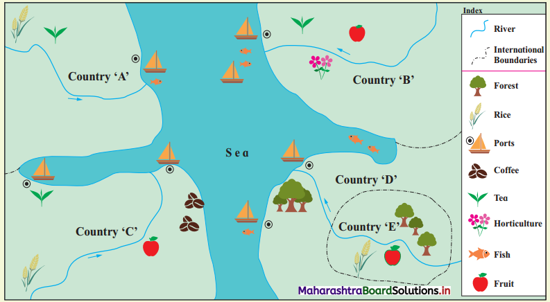
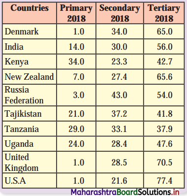
Maharashtra Board Class 12 Geography Solutions Chapter 8 Geography: Nature and Scope

Balbharti Maharashtra State Board Class 12 Geography Solutions Chapter 8 Geography: Nature and Scope Textbook Exercise Questions and Answers.

Maharashtra State Board Class 12 Geography Solutions Chapter 8 Geography: Nature and Scope

1. Identify the correct group.

Question 1.

A B C D
Geomorphology Cartography Tourism Political Geography
Climatology Survey  Forest Conservation Physical Geography
Biogeography Data collection Wildlife Conservation Population Geography
Historical Geography GIS/GPS Culture Conservation Economic Geography

Answer:
B

Maharashtra Board Class 12 Geography Solutions Chapter 8 Geography: Nature and Scope

Question 2.

A B C D
History Economics Biogeography Geomorphology
Sociology Geology Population Geography GIS
Demography Remote sensing Cartography Demography
Political Science Climatology Psychology Pedology

Answer:
A

2. Give geographical reasons.

Question 1.
Human Geography is multidisciplinary in nature.
Answer:

  • Human geography is the branch of geography dealing with human activities and their influence on culture, communities and economies.
  • In human geography every social science studies separately has interface with branch of human geography; because of their spatial attributes.
  • Social sciences like sociology, political science, economics, history and demography are very closely related with branches of human geography, such as social geography, political geography, economic geography and historical geography, respectively.
  • Since, we study varied branches of geography in human geography, it is said to be multidisciplinary in nature.

Question 2.
Geography is dynamic in nature.
Answer:

  • Most geographical phenomena whether physical or human are not static and can change overtime.
  • In economic geography, we study economic activities as well as factors affecting their distribution and changes.
  • In climatology we study changes in temperature and rainfall due to global warming. Depending upon the changes in climate, changes are made in cropping patterns.
  • Geographers study relationship between production, distribution and geographical factors.
  • For example, tea is grown on a large scale in the State of Assam due to high temperature, heavy rainfall, red soil, hilly relief, cheaper water transportation due to the Brahmaputra River and cheap and skilled labour supply from nearby States of Bihar and Orissa.
  • We study weather over a period of about 30 years and decide climate of that place or population of a country or the world over a period of time. Since, changes occur time to time.
    Thus, geography is dynamic in nature.

Question 3.
Geography is dualistic in nature.
Answer:

  • There are two contrasting approaches to study the subject of geography. They are possibilism and environmental determinism. This contrast in approaches is called as dualism in geography.
  • Some geographers are of the view that nature is more dominant than man. It is called environmental determinism. According to them, when we study geography, we study the earth. We study how natural resources have influence on economic activities, as well as food habits of people.
  • For example, in coastal areas fishing activity is more developed and fish is the main food of the people.
  • Some geographers are of opinion that man dominates the nature. It is called possibilism. According to them man can make changes in nature due to his intelligence.
  • For example, there are polyhouses even in polar areas, in which temperature is controlled artificially and vegetables are grown.
  • There are many other thinkers who have different approaches in geography.
    Thus, the study of geography is dualistic in nature.

Maharashtra Board Class 12 Geography Solutions Chapter 8 Geography: Nature and Scope

3. Write short notes on.

Question 1.
Physical Geography is related to various branches of science.
Answer:

  • Almost every discipline, under natural and social sciences is linked with geography.
  • Geomorphology, Climatology, Oceanography and Biogeography are the branches of physical geography.
  • Geomorphology studies landforms, rock types, processes of formation of rocks, landforms, etc. Therefore, it is related to geology.
  • Climatology studies elements of atmosphere such as temperature, winds, rainfall, humidity, natural disasters like cyclones, anticyclones, storms, etc. Therefore, it is related to meteorology.
  • Oceanography studies oceans and seas on the surface of the earth, ocean currents, ocean routes, etc. Therefore, it is related to Hydrology.
  • Biogeography studies the distribution of plants and animals, their species, ecosystems, etc. Therefore, it is related to biology.
  • Knowledge of mathematics is important for cartographic techniques, such as drawing of maps and diagrams. Similarly, knowledge of statistics is useful to do data analysis since various statistical techniques and hypotheses testing are used in data analysis.
  • Thus, physical geography is related to various branches of sciences.

Question 2.
Branches of Geography.
Answer:

  • There are three major branches of Geography – Physical Geography, Human Geography and Geographic Techniques.
  • Geography has various sub-branches; however, the four major sub-branches of Physical Geography are Geomorphology, Climatology, Biogeography and Oceanography.
  • Human geography comprises of six sub-branches, Historical Geography, Political Geography, Economic Geography, Behavioural Geography, Social Geography and Population Geography.
  • Geographic Techniques have four branches, namely, remote sensing, quantification methods in geography, cartography and Geographic Information System (GIS).

Question 3.
Latest trends in Geography.
Answer:

  • Currently, the explanation of all geographic phenomena depends upon the cause and effect relationship.
  • Geographers developed number of disciplines within its boundaries.
  • Number of techniques for analysis and prediction through data collection and modelling are also developed by geographers.
  • Due to the dynamic nature of geography, new things are added in the subject.
  • Use of audio-visual media and information technology has enriched the database.
  • The latest technology of software has brought about better opportunities in data collection, interpretation, analysis and presentation.
  • Presently, the Use of GIS and GPS has become essential. Therefore, maps are made by using GIS software and have proved to be more accurate.
  • Nowadays the use of mathematical modelling and computer models in applied geography has increased. They are used for prediction of weather changes or natural calamities.
  • The above mentioned are all the latest trends in Geography.

Question 4.
Skills required for studying geography.
Answer:

  • The skills required to study the methods and techniques used in geography have made the study of geography empirical and practical in nature.
  • The study of geography is based on theory and observation. It is supported by the scientific study like data collection and data analysis through number of tools and techniques.
  • The geographers developed skills for conducting surveys with the help of advanced technology. They have also acquired the skills to make use of satellite images for data collection.
  • The geographers have attained the skills for experiments, data collection, data organisation, observation patterns, data analysis, research findings, etc.
  • The geographers have learnt analytical techniques of data with the help of statistical techniques and representation of statistical data using graphs and maps.

Maharashtra Board Class 12 Geography Solutions Chapter 8 Geography: Nature and Scope

4. Answer the following questions in detail.

Question 1.
Explain how the knowledge of Geography is important in our day-to-day life. Give examples.
Answer:

  • The knowledge of geography is important in our day-to-day life because with geographical knowledge we can understand the basic physical systems that affect our everyday life.
    For example, the earth-sun relationship, water cycle, wind, ocean currents, etc.
  • For the effective functioning of different places, we learn the physical and cultural characteristics of places.
  • With the help of geography, we can understand the geography of the past, how geography had played an important role in the evolution of people, their ideas, places and environment.
  • We can prepare a map of a province or territory, country and the world, so that one can understand the location of various countries. For example, the political map of the Asian continent gives idea about location of Asian countries.
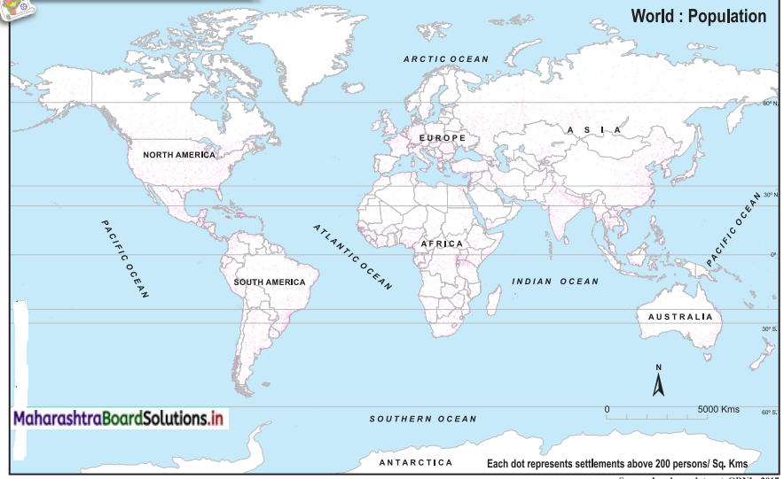
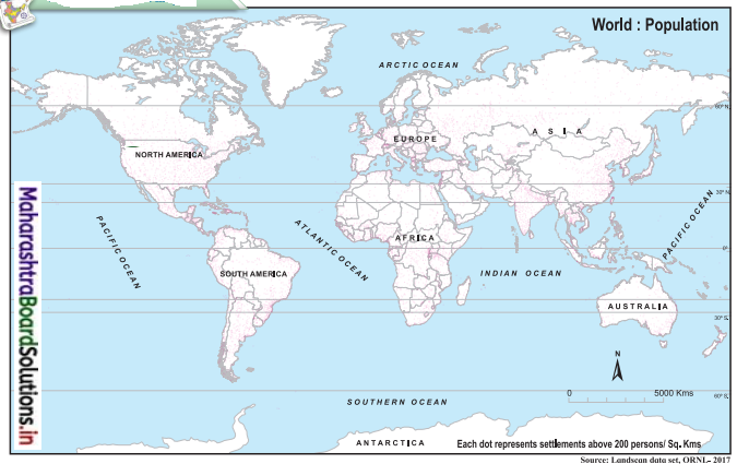
  • With the help of various distribution maps, we can understand distribution of minerals, crops, population, etc., in the world. For example, with the help of dot map we can understand spatial distribution of population in the world.
  • With the help of economic geography, we can understand the development of economic activities in different countries of the \yorld and their correlation with physical and economic factors. For example, we can study the world’s leading areas in fishing activities and their reasons.
  • With the help of climatology, we understand atmospheric phenomenon, such as cyclones, global warming, etc.
  • The study of sustainable development in geography teaches us to appreciate the earth as humankind’s homeland and provide an insight for wise management decisions about the usage of the earth’s resources.
  • With the help of geography, we can understand global inter-dependence to become a better global citizen.
  • Thus, with the help of geography, we can study physical features, economic activities, trade, people, etc., in the world.

Question 2.
Discuss the relationship between Geography and other subjects.
Answer:

  • Geography is related to almost every discipline under natural and social sciences. There are three major branches of Geography, namely, Physical Geography, Human Geography and Geographic Techniques.
  • Geography has various sub-branches; however, the four major sub-branches of Physical Geography are Geomorphology, Climatology, Biogeography and Oceanography.
  • In Geomorphology we study the formation and types of landforms, gradient, rock structure, etc. This is related to the subject of geology.
  • In Climatology we study the atmospheric elements such as temperature winds, rainfall, humidity, natural disasters like cyclones, anticyclones, storms, etc. This it is related to the subject of meteorology.
  • In Oceanography we study the ocean currents, ocean routes, coastal features, submarine relief, etc., of oceans and seas. This it is related to the subject of hydrology.
  • In geography of soil, we study the components, layers, texture, and fertility of the soil, etc. This is related to the subject of pedology.
  • Human geography comprises of six sub-branches, Historical Geography, Political Geography, Economic Geography, Behavioural Geography, Social Geography and Population Geography. In historical geography, we study the correlation of historical events with geographical factors. This is related to the subject of history.
  • In Political Geography, we study the effect of geographical factors on political events. This is related to the subject of political science.
  • In Economic Geography, we study the correlation of geographical factors and economic activities. This is related to the subject of economics.
  • Similarly, Behavioural Geography, Social Geography and Population Geography are related to the subjects of psychology, sociology and demography respectively.
  • Thus, it can be concluded by saying that geography has a strong relationship with other subjects in natural as well as human or social sciences.

Maharashtra Board Class 12 Geography Solutions Chapter 8 Geography: Nature and Scope

Question 3.
Explain the nature of Geography in detail.
Answer:

  • Geography is the study of the earth as a home of man, and various phenomena related to it.
  • Therefore, geography is the study of the physical environment in relation to man. The physical environment has direct effect on cultural and social environments.
  • The earth is dynamic in nature. Hence, we find variations in its physical and cultural/social environments.
  • In geography we study the relation between the physical environment and production, distributions and their patterns and variations.
  • Geographers study the location, geographical phenomena, whether physical or human, which are highly dynamic and its causes.
  • Since geography is the study of space and time it makes geography dynamic in nature.
  • In geographical study, the geographer tries to answer questions like what, why, where and when.

5. Differentiate between.

Question 1.
Physical Geography and Human Geography
Answer:

Physical Geography Human Geography
(i) Physical Geography is the branch of geography dealing with natural features. (i) Human Geography is the branch of geography dealing with how human activities influence the culture, communities, economies, etc.
(ii) Geomorphology, Climatology, Oceanography, Biogeography, Geography of soils, are the branches of Physical Geography. (ii) Historical Geography, Political Geography, Economic Geography, Behavioural Geography, Social Geography and Population Geography are the branches of Human Geography.
(iii) Physical geography is natural science. (iii) Human geography is a social science.

Question 2.
Possibilism and Determinism.
Answer:

Possibilism Determinism
(i) When man dominates nature, it is called possibilism. (i) When nature dominates man, it is called determinism.
(ii) Due to intelligence, man makes changes in the natural environment. (ii) Determinism asserts that development of human history, culture, society, lifestyle, etc., are shaped by their physical environment.
(iii) There are limitations to changes made by man in nature. (iii) There are no limitations on impact of physical environment on human activities.

Maharashtra Board Class 12 Geography Solutions Chapter 8 Geography: Nature and Scope

6. Draw a neat and well-labelled diagrams

Question 1.
Relationship between Geography and other subjects.
Answer:
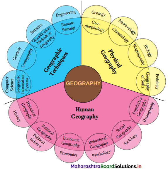
Maharashtra Board Class 12 Geography Solutions Chapter 8 Geography Nature and Scope 1

Question 2.
Skills required to study Geography.
Answer:
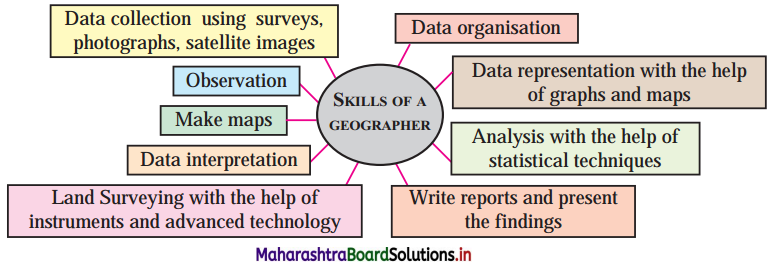
Maharashtra Board Class 12 Geography Solutions Chapter 8 Geography Nature and Scope 2

Class 12 Geography Chapter 8 Geography: Nature and Scope Intext Questions and Answers

Let’s recall

Question 1.
Dear students, you have been studying geography either as a part of Environmental Studies since Standard III or as Social Studies since Standard VI and as an independent subject since Standard XI. Your journey to understand our homeland earth began with the study of the cardinal directions in Standard III. In the consecutive academic years, you learnt various geographical concepts. Now just recall the various concepts that you have learnt till now and make a list of them. Also classify them under different categories given in the table 8.3. (Textbook Page No. 75)
Answer:
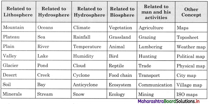
Maharashtra Board Class 12 Geography Solutions Chapter 8 Geography Nature and Scope 3

Maharashtra Board Class 12 Geography Solutions Chapter 8 Geography: Nature and Scope

Can you tell?

Discuss the following points in class with reference to its importance in the subject matter of Geography. (Textbook Page No. 77)
Question 1.
Environment vs. Man
Answer:
Man and environment are inter-related. The environment influences the life of human beings who in-turn modifies the environment as a result of their growth, dispersal, activities, death, etc. Thus, all living beings including man and their environment are mutually reactive affecting each other in a number of ways and a dynamic equilibrium is possible between the two, i.e., human beings and environment are interdependent. If the natural environment helped in the development of different structures of the society on the one hand, the existence and quality of environment now rests on the responses of these social structures to the environment on the other hand.

The burning issues like quality of environment, disruption of earth’s natural ecosystems, environmental degradation and pollution, ecological imbalances, depletion of resources, etc., can be approached and solved only after considering the value judgments which may be determined by taking into account the consequences of ‘Environmental Improvement Programme’ on the entire society and society’s response towards the programme. However, all these depend on the interest and desire of the society in improving the quality of environment.

The interaction between the environment and man depends largely on the social and political system. The differential interactions are due to the uneven distribution of natural resources, uneven economic and social development, dissimilarities of demographic factors, varying view points of the governments and individuals towards the environment, etc.

Continuous and exceedingly increasing rate of exploitation of natural resources, industrialisation, technological growth, unplanned urbanisation and profit-oriented capitalism by the developed western world are responsible for grave environmental crisis and ecological imbalance not confined to their own countries but to the whole world.

The changes in the relationship between man and environment depend upon the change in organisation and attitude of man. To improve environmental stand and to maintain ecological balance, the following remedies are important

  • Rapid growth of population
  • Rational use of non-polluted water resources
  • Use of organic fertilizers for agricultural growth
  • To check soil erosion
  • Restoration of forest resources
  • To check pollution

Maharashtra Board Class 12 Geography Solutions Chapter 8 Geography: Nature and Scope

Question 2.
Complete study of India vs. Study of only agriculture in India.
Answer:
[Note: In India, it is not possible to provide a complete study of India and agriculture within the scope of a book.]

Try These

Question 1.
Given here are some of the concepts or subject matter we study in Geography. Write the name of subjects or disciplines you think they are also studied in. Complete the table 8.2. (Textbook Page No. 78)
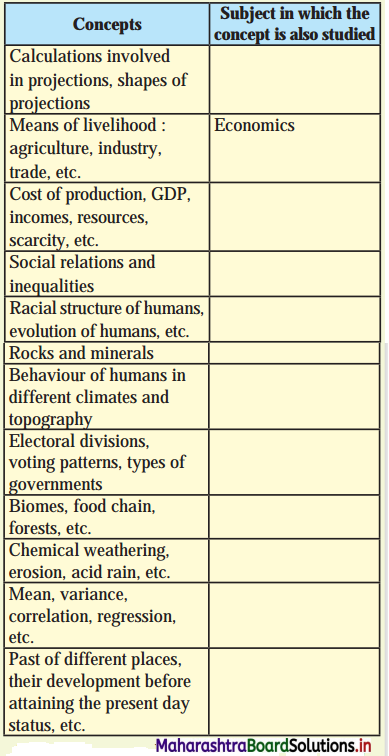
Maharashtra Board Class 12 Geography Solutions Chapter 8 Geography Nature and Scope 4
Answer:

Concepts Subject in which the concept is also studied
Calculations involved in projections, shapes of projections Cartography
Means of livelihood: agriculture, industry, trade, etc. Economics – Economic Geography
Cost of production, GDP, incomes, resources, scarcity, etc. Economics – Economic Geography
Social relations and inequalities. Sociology – Social Geography
Racial structure of humans, evolution of humans, etc. Anthropology -Human Geography
Rocks and minerals Geology – Geomorphology
Behaviour of humans in different climates and topography. Psychology – Behavioural Geography
Electoral divisions, voting patterns, types of governments Politics – Political Geography
Biomes, food chain, forests, etc. Biology – Biography
Chemical weathering, erosion, acid rain, etc. Geography – Physical Geography
Mean, variance, correlation, regression, etc. Statistics – Statistical Geography
Past of different places, their development before attaining the present-day status, etc. History – Historical Geography

Maharashtra Board Class 12 Geography Solutions Chapter 8 Geography: Nature and Scope

Question 2.
In Fig 8.5, a newspaper item is given. A list of job opportunities is given. Go through all the entries and see which ones are suitable for a geographer as a career. (Textbook Page No. 80)
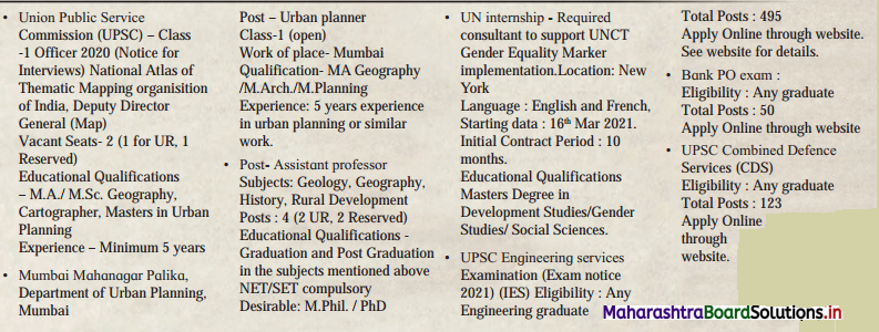
Maharashtra Board Class 12 Geography Solutions Chapter 8 Geography Nature and Scope 5
Answer:
The following is the list of jobs opportunities suitable for a geographer as a career.
(i) National Atlas of Thematic Mapping Organisation of India.
(ii) Mumbai Mahanagar Palika, Department of Urban Planning, Mumbai, as Urban Planner
(iii) Assistant Professor in the subject of Geography
For all above posts basic qualification is minimum M.A./M.Sc. in Geography.

Maharashtra Board Class 12 English Yuvakbharati Solutions Chapter 1.1 An Astrologer’s Day

Balbharti Yuvakbharati English 12th Digest Chapter 1.1 An Astrologer’s Day Notes, Textbook Exercise Important Questions and Answers.

Maharashtra State Board Class 12 English Yuvakbharati Solutions Chapter 1.1 An Astrologer’s Day

12th English Digest Chapter 1.1 An Astrologer’s Day Textbook Questions and Answers

Question 1.
Discuss with your partner and complete the table:
Maharashtra Board Class 12 English Yuvakbharati Solutions Chapter 1.1 An Astrologer's Day 1
Answer:

Your Strengths Why do you feel so? Your Dream career
painting and drawing can visualise, express commercial artist, cartoonist
……………………. ……………………… ………………………….
…………………… ……………………… …………………………
………………….. ……………………….  ………………………..

Maharashtra Board Solutions

Question 2.
The scene in a local market of a village/ town/city is very attractive. People with different occupations sell their wares. Discuss with your partner the variety of activities at the local market.
Answer:

  1. selling flowers, selling grocery
  2. selling garments and cloth
  3. selling imitation jewellery and accessories
  4. selling snacks and fast food
  5. selling steel and earthenwares

Question 3.
In a village/town/city it is quite a common sight to see an astrologer sitting by the roadside with his professional equipment. Discuss with your partner and list the requirements for his trade.
Answer:

  1. parrot, cards, etc.
  2. turban, beard, dhoti
  3. dried leaves with writing on them
  4. cloth with mystic signs to spread his cards
  5. bead necklace, coins, shells, punchang, etc.

Question 4.
There are certain unreasonable beliefs among people living in our society. Certain common events are linked with superstitions. List such events, discuss the superstitions linked with them and the means of their eradication.
Answer:
Events and superstitions linked with them:

  1. A cat crossing your path (something bad will happen)
  2. Walking under a ladder (something unfortunate will happen)
  3. Wearing black clothes for an auspicious function (will bring bad luck to the hosts)
  4. Spilling salt (unlucky for the person)
  5. A black crow cawing outside your window (you will be having guests)

Means of eradication: The only means of eradication is through education. Scientific attitude must be developed in society. Religious heads must counsel and guide their followers. The elders in families must also get rid of old beliefs.

A1.

(i) Given below are some descriptions. Discuss them with your partner and find out one word for each of them.

Question (a)
The scientific study of the universe and the objects in it, including stars, planets, nebulae and galaxies:
Answer:
Astronomy

Maharashtra Board Solutions

Question (b)
The study of the movements of the planets, Sun, Moon, and Stars in the belief that these movements can have an influence on people’s lives:
Answer:
Astrology

Question (c)
A prediction of what will happen in the future:
Answer:
Prophecy

Question (d)
Scientific discipline that studies mental states and processes and behaviour in humans and other animals:
Answer:
Psychology

Question (ii)
In the story we are told that the Town Hall Park was a remarkable place in many ways for an astrologer to build his business. List the exceptional qualities of the place from this extract.
Answer:
The exceptional qualities of the place were:

  1. A surging crowd
  2. A variety of trades and occupations, like medicine sellers, sellers of stolen hardware and junk
  3. magicians
  4. auctioneers of cheap cloth
  5. a vociferous vendor of fried groundnuts.

Question (iii)
The astrologer never opened his mouth till the other had spoken for at least ten minutes. Discuss the reasons behind his act.
Answer:
(a) He was good at reading people.
(b) He obtained a lot of information about their lives from their talk.
(c) He could analyse their character and understand their problems.
(d) He could easily frame his statements to their satisfaction.

Maharashtra Board Solutions

A2.

Question (i)
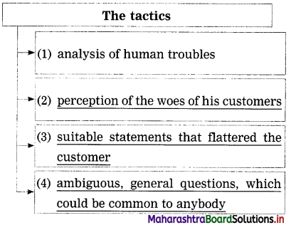
The tactics used by the astrologer to earn his wages are:
Maharashtra Board Class 12 English Yuvakbharati Solutions Chapter 1.1 An Astrologer's Day 2Maharashtra Board Class 12 English Yuvakbharati Solutions Chapter 1.1 An Astrologer's Day 2
Answer:
Maharashtra Board Class 12 English Yuvakbharati Solutions Chapter 1.1 An Astrologer's Day 3

Question (ii)
An astrologer’s appearance helps to create an impression on his clients. Complete the following:
(The answer is given directly and underlined.)
Answer:

  1. The turban on his head
  2. The sacred ash and vermilion on his forehead
  3. dark whiskers covering the face
  4. a sparkle in his eye accompanied by an abnormal gleam

1. Read the following sentences and choose the correct one:

Question (a)
The astrologer says that if Nayak does not leave his village again, he would –
(1) return the money
(2) face danger
(3) go back home and stop looking for the man who tried to kill him
(4) not find the killer.
Answer:
(2) face danger

Question (b)
According to the narrator, the astrologer’s success in his profession is primarily due to –
(1) luck
(2) the bargains he drives
(3) his appearance
(4) his understanding of people.
Answer:
(4) his understanding of people

Maharashtra Board Solutions

Question (c)
The story suggests that the astrologer’s comments and observations pleased people by –
(1) promising them success and good fortune
(2) proving, as time passes, to have been true
(3) flattering them or supporting their own views
(4) helping them to learn to solve their own problems.
Answer:
(3) flattering them or supporting their own views

Question (d)
Guru Nayak the astrologer because he wants to –
(1) understand the past
(2) find out who the astrologer is
(3) make some money through a bet
(4) get the answer to a specific question.
Answer:
(4) get the answer to a specific question.

Question (e)
Guru Nayak is looking for the man who tried to kill him –
(1) to take revenge
(2) to get an apology
(3) to demand an explanation
(4) to prove that the man was unsuccessful.
Answer:
(1) to take revenge

Question (f)
The astrologer’s remarks make Guru Nayak feel all of the following except –
(1) relieved
(2) suspicious
(3) impressed
(4) disappointed.
Answer:
(2) suspicious

Maharashtra Board Solutions

Question (g)
Reactions of the astrologer’s wife to his news suggest that she –
(1) was unaware of his past
(2) has been worried about his safety
(3) has known him since he was young
(4) is concerned about her future with him.
Answer:
(1) was unaware of his past

Question (iv)
Read the following sentences and find out the True and False sentences. Correct the False sentences:
(a) The astrologer gave a correct prediction to the client about his past that he was stabbed, thrown into a well and left for dead
(b) When the astrologer came to know that the man whom he killed is alive he felt that he was relieved of his guilt.
(c) The astrologer tried to back out of the deal and talked about the client’s past.
(d) The astrologer rescued himself from Guru Nayak’s revenge.
(e) The moral of the story is that we must be responsible about what we have done and should not run away from our mistakes.
Answer:
(a) True.
(b) True: When the astrologer came to know that the man whom he killed is alive he felt that he was relieved of his guilt.
(c) False
Corrected sentence. The astrologer struck a bargain with the client and then talked about the client’s past.
(d) True.
(e) False: The moral of the story is that we must be responsible about what we have done and should not run away from our mistakes.
Corrected sentence: The moral is that we should never believe in superstitions.

Maharashtra Board Solutions

Question (v)
The astrologer had changed his appearance and his persona when he arrived in the city. Give specific reasons for this.
Answer:
The astrologer thought that he had killed a man after a quarrel. He was afraid that he would be arrested and jailed for this crime. Hence, to avoid detection he changed his appearance and his persona when he arrived in the city.

Question (vi)
‘The darkness load that was inside the astrologer has disappeared’. Through this sentence, explain the significance of the title ‘An Astrologer’s Day’.
OR
(vii) The astrologer feels relieved that Guru is not dead as it relieves a great burden from him. Critically justify the statement and explain it.
Answer:
The astrologer thought that he had killed a man after a quarrel. Hence he had run away from his village, changed his appearance and his persona when he arrived in the city, and become an astrologer. However, he still felt guilty for what he had done. When he came to know that the man he thought he had killed was actually alive, the dark load inside him disappeared, and it made his day, i.e. he felt relieved and happy. This is the significance of the title ‘An Astrologer’s Day’.

Question (viii)
The astrologer wins/gets the sympathy/ criticism of the reader in the end. Express your opinion with the support of the main story.
Answer:
I think I sympathize with the astrologer. He did not try to intentionally kill Guru Nayak; it had happened in the heat of the moment. Of course, he should not have tried to run away but should have accepted responsibility for his crime. However, he is genuinely sorry for what had happened.

His words ‘a great load is gone from me today. I thought I had the blood of a man on my hands all these years’ indicates this. Hence, I sympathize with him and am happy that he can now live in peace.

Maharashtra Board Solutions

Question (ix)
Suggest some steps to eradicate superstitions and other ill practices from our society.
Answer:
To eradicate superstitions and other ill practices from our society the first and most important step is education. Schools and colleges must help their students to develop a scientific attitude and think logically and rationally.

Secondly, as people in India tend to listen to their religious heads, all religious heads should send out clear messages to their followers about the eradication of superstitions. And lastly, the older generation should change their opinions and ideas and get rid of silly superstitious beliefs.

Question (x)
In the story, the astrologer has great listening power. Listening helps in developing good relations with people. Express your opinion.
Answer:
Yes, listening helps in developing good relations with people. When we listen, we indicate to the speaker that we care about him/her and are interested in his/her problems/joys. We show that we are ready to help him/her if necessary. We share his/ her ideas. We also realize how we can deal with people successfully by listening to their views.

(A3)

Question (i)
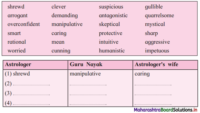
In the story, the astrologer, Guru Nayak and astrologer’s wife reveal their qualities through words and actions. Pick out from the box the words that describe them and write in the appropriate columns:
Maharashtra Board Class 12 English Yuvakbharati Solutions Chapter 1.1 An Astrologer's Day 4
Answer:

Astrologer Guru Nayak Astrologer’s wife
shrewd manipulative caring
clever gullible suspicious
smart quarrelsome protective
sharp arrogant worried
intuitive aggressive humanistic
mystical demanding rational
cunning antagonistic
mean sceptical
over­ impetuous
confident

Maharashtra Board Solutions

Question 1.
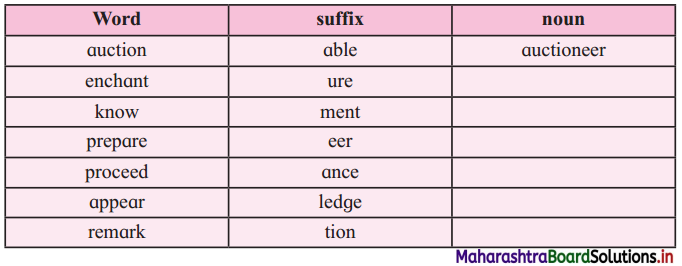
Match the suffixes with the words and make words:
Maharashtra Board Class 12 English Yuvakbharati Solutions Chapter 1.1 An Astrologer's Day 5
Answer:

Word Suffix Noun
auction able auctioneer
enchantment enchantment enchantment
know ment knowledge
prepare ure preparation
proceed tion procedure
appear (this word is not in the lesson) ment appearance
remark ure remarkable

Question (iii)
‘An Astrologer’s Day’ has ironic elements where the astrologer pretends to have ‘supernatural knowledge’ that coincidently turns out to be the truth. Find out an example of irony from the extract and write it down:
Find out the examples of irony from the extract and write them down.
Answer:
His eyes sparkled with a sharp abnormal gleam which was really an outcome of a continual searching look for customers, but which his simple clients took to be a prophetic light and felt comforted.
1. He knew no more of what was going to happen to others than he knew what was going to happen to himself the next minute.
2. He was as much a stranger to the stars as were his innocent customers.
3. He said things which pleased and astonished everyone : that was more a matter of study, practice, and shrewd guesswork.

Maharashtra Board Solutions

Question (iv)
Find the examples of code-mixing from the extract and write them down.
Answer:
1. ‘cowrie shells’
2. turban

Question (v)
There are some phrases where the word ‘crown’ is used with different shades of meaning. Use the following phrases to complete the sentences meaningfully. One is done for you.
Crowning achievement, to crown the effect, crown of thorns, crowning glory, to crown it all
Answer:
e.g. To crown the effect, he wound a saffron- coloured turban around his head.
(a) The works of Shakespeare are the crowning glory of English drama.
(b) Amitabh has given us awesome movies throughout five decades. But his crowning achievement is his performance in the movie ‘Black’.
(c) In her pursuit of success, Radha has distanced herself from her family. Her fame has become a real crown of thorns.
(d) They threw a wonderful party for me with costumes, games and to crown it all my favourite kind of ice cream.
(e) Medical science has great inventions, but organ transplantation is definitely a crowning achievement for human beings.

(A4)

Question (i)
Use the word given in the brackets and rewrite the sentence:
(a) The power of his eyes was considerably enhanced. (enhancement)
(b) He had a working analysis of mankind’s troubles, (worked)
(c) He knew what was going to happen to himself the next minute. (happening)
(d) If you find my answers satisfactory, will you give me five rupees? (satisfaction)
(e) He shook his head regretfully. (regret)
(f) It was a bewildering crisscross of light rays, (bewildered)
(g) “I should have been dead if some passer-by had not chanced to peep into the well,” exclaimed the other, overwhelmed by enthusiasm. (enthusiastically)
(h) You tried to kill him. (killing)
(i) I will prepare some nice stuff for her. (preparation)
(j) The other groaned on hearing it. (heard)
Answer:
(a) There was considerable enhancement in the power of his eyes.
(b) He had worked out an analysis of mankind’s troubles.
(c) He knew what could be happening to himself the next minute.
(d) If my answers give you satisfaction, will you give me five rupees?
(e) He shook his head with regret.
(f) He was bewildered by the crisscross of light rays.
(g) “I should have been dead if some passer-by had not chanced to peep into the well,” exclaimed the other enthusiastically.
(h) You tried killing him.
(i) I will make a preparation of some nice stuff for her.
(j) The other groaned when he heard it.

Maharashtra Board Solutions

(A5)

Question (i)
Prepare a speech on Science and Superstitions.
Answer:
Science and Superstitions
Respected teacher and my dear friends,

I wish you all a very good morning. Today we are celebrating Science day in our school, and on this occasion I, Rohan Kamte, would like to say a few words about Science and Superstitions.

Science and Superstitions are two opposite ends of a pole. Those who have the scientific attitude and believe in science cannot possibly believe in superstitions. After all, what exactly are superstitions? They are only some tales made up by people for some reason or the other. Let me give you an example. Many years ago, in a house in a village, they were having an auspicious function. A lot of food was being cooked.

A cat and her kitten were moving about here and there in the kitchen. Afraid that the cat would be trampled upon or may fall into one of the open fires, the mistress of the house ordered the servant to put the cat and its kitten under a basket, and to do so every time there was a function in the house. This became a ‘superstition’ and in some houses, people actually brought a cat into the house and put it under a basket whenever they had a function!

This is what superstitions are all about. The superstition of bad luck if you walk under a ladder too has its reasons. The ladder could fold up and injure a person walking beneath it, or something could fall on the person’s head.

So friends, I request you: In this age of Science, do not believe in silly superstitions. Keep your minds open. Be rational and logical. Analyse things. Believe something only if it has the backing of Science. Thank you.

(ii) Read the following proverbs. Share you views and expand the ideas.

Question (a)
Actions speak louder than words.
Answer:
Actions speak louder than words

Today a lot of importance is being given to the way we speak and what we speak. But we have to remember that ultimately it is not words but actions that are important. Mahatma Gandhi, the Father of our Nation, did not give any grand speeches. However, by his actions he saw that India gained her freedom. Our soldiers do not give long lectures on patriotism they merely act to defend the country. What would have happened if they had only spoken but not acted?

This very well-known proverb is very apt when it comes to parent-child interaction. It has been seen that children observe the actions of their parents and imitate them not their words. In the animal kingdom too, the actions of the parent are of paramount importance. During elections, politicians make loud speeches but later on do not work. It is because of this behaviour that they lose the trust of the people. Thus, we must act with responsibility, always remembering that people observe our actions and are not swayed by our words.

Maharashtra Board Solutions

Question (b)
The face is the index of the mind.
Answer:
[Points: facial expressions and eyes indicate one’s thoughts – this is. non-verbal communication – that is why we smile when happy and frown when sad – however, smart people can hide their feelings so that face does not show them – so one has to be careful while reading faces]

Question (c)
Speech is silver and silence is golden.
Answer:
[Points: we speak – we give others information or reveal our thoughts – others speak, we get information – sometimes we speak hastily and hurt others – create problems – remain silent and think – can find solutions – many leaders speak hastily – create international problems – better to be silent and let one’s actions speak]

Question (d)
Argument is the worst kind of communication.
Answer:
[Points: arguments – people get angry – angry words and raised voices – hurt people – confusion – relationships spoilt – instead talk softly and allow others to talk – accept that others can think in a different way – ‘a man convinced against his will is of the same opinion still’]

Question (e)
Attitudes are the real figures of speech.
Answer:
[Points: quote by Edwin H Friedman – in communication, more than the verbal message, the non-verbal message important – your attitude and behaviour have more impact than your words – for example, if you say ‘sorry’ in a harsh tone without any apology on your face – the word has no meaning – hence body language and attitude are very important)

Question (f)
The wise man has long ears and a short tongue
Answer:
[Points: better to listen than to speak – wise people listen more and speak only when they have something important to say – speech is silver and silerwe is golden – in any situation it is better to remain silent and evaluate situation – empty vessels make the most noise]

Maharashtra Board Solutions

(A6)

Question (i)
Bill Naughton has written a collection of wonderful stories which you can read in his book ‘The Goal Keeper’s Revenge and Other Stories’. Read all the stories and discuss their themes with your partner.

Question (ii)
Read R.K. Narayan’s humorous collections of short stories and novels. Here are some titles you can read.
(a) ‘Under The Banyan Tree’
(b) ‘The Doctor’s Word’
(c) ‘LawleyRoad’
(d) ‘A Horse and Two Goats’
(e) ‘Gateman’s Gift’

(A7)

Question 1.
Surf the internet and find out the career opportunities in Astronomy.

Yuvakbharati English 12th Digest Chapter 1.1 An Astrologer’s Day Additional Important Questions and Answers

Read the extract and complete the activities given below:

Global Understanding:

Question 1.
List the fancy names the vendor of fried groundnuts gave his wares.
Answer:
The fancy names the vendor of fried groundnuts gave his wares are:

  1. ‘Bombay Ice Cream’
  2. ‘Delhi Almond’
  3. ‘Raja’s Delicacy’, etc.

Question 2.
Complete the following:
(The answer is given directly and underlined.)
Answer:
If the astrologer had stayed in the village, he would have carried on the work of his forefathers-namely, tilling the land, living, marrying and growing old in his cornfield and ancestral home.

Maharashtra Board Solutions

Question 3.
The Town Hall Park was a remarkable place in many ways for an astrologer to build his business. List the exceptional qualities of the place from the extract.
Answer:
The exceptional qualities of the place were:

  1. lack of municipal lighting
  2. flare from the groundnut heap
  3. hissing gaslights, some with naked flares, and cycle lamps
  4. bewildering criss-cross of light rays and moving shadows

Question 4.
Complete the following:
(The answers are given directly and underlined.)
The signal for the astrologer to leave was when the nuts vendor blew out his flare and rose to go home.
The astrologer spoke only when his client had spoken for at least ten minutes.

Question 5.
Rearrange the following sentences in the order of their occurrence in the extract:

  1. “I will speak to you tomorrow.”
  2. “Oh, stop that,” the other said.
  3. “There is a woman ”
  4. “Or will you give me eight annas?”

Answer:

  1. “Oh, stop that,” the other said.
  2. “Or will you give me eight annas?”
  3. “I will speak to you tomorrow.”
  4. “There is a woman ………..”

Complex Factual:

Question 1.
Complete the following:
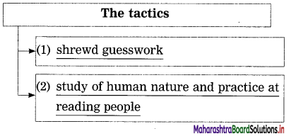
(The answer is given directly and underlined.) The tactics used by the astrologer to earn his wages are:
Answer:
Maharashtra Board Class 12 English Yuvakbharati Solutions Chapter 1.1 An Astrologer's Day 6

Question 2.
Describe how the astrologer had left the village.
Answer:
The astrologer had left the village without any previous thought or plan. He had left home without telling anyone. He did not rest till he left behind his village a couple of miles.

Maharashtra Board Solutions

Question 3.
The astrologer could understand the problem in five minutes. Give reasons from the extract.
Answer:
The astrologer had a working analysis of mankind’s troubles like marriage, money and the tangle of human ties. Long practice had sharpened the way he perceived things, and thus he could understand the problem in five minutes.

Question 4.
Complete the following :
(The answer is given directly and underlined.)
Answer:
Maharashtra Board Class 12 English Yuvakbharati Solutions Chapter 1.1 An Astrologer's Day 7

Question 5.
Complete the web:
(The answers are given directly and underlined.)
Answer:
Maharashtra Board Class 12 English Yuvakbharati Solutions Chapter 1.1 An Astrologer's Day 8

Question 6.
Complete the following with what had happened to Guru Nayak’s enemy, according to the astrologer. According to the astrologer ………….. .
Answer:
According to the astrologer, Guru Nayak’s enemy had died. He had been crushed by a lorry.

Maharashtra Board Solutions

Question 7.
Describe the load on the astrologer’s mind.
Answer:
The astrologer thought that he had killed a man after a quarrel. He felt intensely guilty about this, and had run away from his village. This feeling of guilt was the load on his mind.

Question 8.
Was the astrologer’s wife happy with his day’s earnings? What did she plan to do with it?
Answer:
Yes, the astrologer’s wife was overjoyed with his day’s earnings. She planned to buy some jaggery and coconut and make some sweets for their daughter.

Inference/Interpretation/Analysis:

Question 1.
The presence of the groundnut vendor is beneficial to the astrologer. Justify.
Answer:
The vendor of fried groundnuts gave his wares fancy names like ‘Bombay Ice Cream’, ‘Delhi Almond’, ‘Raja’s Delicacy’ and so on. People were amused and attracted by this and flocked to him to buy groundnuts. As the astrologer was seated right next to him, the groundnut vendor’s customers dallied near the astrologer and were probably tempted to consult him.

Question 2.
Pick out the lines that tell you that the astrologer did not have any real knowledge of astrology.
Answer:

  1. He had not in the least intended to be an astrologer when he began life.
  2. He knew no more of what was going to happen to others than he knew what was going to happen to himself the next minute.
  3. He was as much a stranger to the stars as were his innocent customers.
  4. It was a bewildering crisscross of light rays and moving shadows. This suited the astrologer very well.

Question 3.
The astrologer could tell the person/client about his life. Describe the method he used.
Answer:
The astrologer would listen to his client talk for about ten minutes. He would thus get all the information about his life from him, and then cleverly pose questions which made it appear that he actually knew about the person’s life.

Maharashtra Board Solutions

Question 4.
‘Our friend felt piqued.’ Name the friend and give reasons for him feeling ‘piqued’.
Answer:
‘Our friend’ is the astrologer. He felt piqued because the man cut short his words rudely and told him to tell him something worthwhile. The astrologer was used to people listening eagerly and respectfully to whatever he had to say, and the behaviour of the man showed that he did not value the usual smooth talk. That is why the astrologer felt piqued.

Question 5.
Complete the following:
(The answers are given directly and underlined.)
Answer:
1. The man was left for dead because he had been pushed into a well in a field. Nobody normally looked into the well, and he would have died had there not been a passer-by who chanced to peep into the well.
2. The man looked gratified because his enemy had met his death by being crushed under a lorry. Guru Nayak felt that the man deserved such a terrible fate for what he had done to him.

Personal Response:

Question 1.
Do you like to hear predictions about your future? Give reasons.
Answer:
No, I do not like to hear predictions about my future. I do not believe that any person can foretell what is going to happen in someone’s life. Astrology is just a way of making money from gullible people. I believe that one must work hard and be a good human being if one wants to be successful in life.

Question 2.
Do you think that astrology is an art and can be studied? Discuss.
Answer:
Yes, astrology is an art. There are various methods of predicting the future, like palm-reading, reading the pulse, reading the horoscope, etc. These methods can be studied, or the knowledge can be inherited from one’s ancestors. However, the astrologer must have intuition and talent for this art.

Maharashtra Board Solutions

Question 3.
Explain with examples your reactions when someone challenges you.
Answer:
If the challenge is worthwhile, I take it up. For example, my friend Rohan challenged me to a bicycle race to the top of a nearby hill. I took it up as it was interesting, and I knew I could do it.

However, when my friend Soham challenged me to jump from the first floor of our building, I refused the challenge, as I knew it was dangerous and I was likely to break some bones. Though Soham scoffed at me, and said that he had already done it, I did not let his ridicule bother me.

Language Study:

Question 1.
The power of his eyes was considerably enhanced by their position.
(Rewrite beginning ‘The position …………’)
Answer:
The position of his eyes considerably enhanced their power.

Question 2.
This colour scheme never failed.
(Rewrite as an affirmative sentence.)
Answer:
This colour scheme was always successful.

Maharashtra Board Solutions

Question 3.
He had left his village without any previous thought or plan. (Rewrite using neither … nor …’)
Answer:
He had left his village with neither any previous thought nor plan.

Question 4.
One or two had hissing gaslights. (Identify the part of speech of the underlined word.)
Answer:
hissing – adjective (present participle used as an adjective)

Question 5.
He never opened his mouth till the other had spoken for at least ten minutes.
(Rewrite using ‘only’.)
Answer:
He opened his mouth only after the other had spoken for at least ten minutes.

Question 6.
He looked up and saw a man standing before him. (Rewrite as a simple sentence.)
Answer:
Looking up, he saw a man standing before him.

Question 7.
If I prove you are bluffing, you must return that anna to me with interest. (Pick out the clauses and state their type.)
Answer:
you must return that anna to me with interest-main clause
If I prove you are bluffing-adverb clause of condition

Question 8.
“Tell me something worthwhile.” (Identify the type of sentence.)
Answer:
Imperative sentence.

Maharashtra Board Solutions

Question 9.
Never travel southward again, and you will live to be a hundred. (Rewrite using ‘only if)
Answer:
You will live to be a hundred only if you never travel southward again.

Question 10.
He flung the coins at her and said “Count them. One man gave all that.” (Rewrite in reported speech.)
Answer:
He flung the coins at her and instructed her to count them. He added that one man had given all of it.

Question 11.
I will prepare some nice stuff for her. (Rewrite using the past perfect tense of the verb.)
Answer:
I had prepared some nice stuff for her.

Vocabulary:

Question 1.
Match the suffixes with the words and make words:
Answer:

Word Suffix Noun
innocent able innocence
reason ledge reasonable

Question 2.
Pick out two words from the extract that indicate sound.
Answer:
crackled, hissing

Question 3.
Guess the meaning of ‘pies’
Answer:
pies – is the plural form of pie which is a former bronze coin of India, the 12th part of an anna.

Maharashtra Board Solutions

Question 4.
Find an example of code mixing from the extract and write it down.
Answer:
pies

Question 5.
Find out the examples of irony from the extract and write them down.
Answer:
1. When he told the person before him, gazing at his palm, “In many ways you are not getting the fullest results for your efforts,” nine out of ten were disposed to agree with him.
2. “Most of your troubles are due to your nature. How can you be otherwise with Saturn where he is? You have an impetuous nature and a rough exterior.” This endeared him to their hearts immediately, for even the mildest of us loves to think that he has a forbidding exterior.

Question 6.
Guess the meaning of the words:

  1. tilting
  2. bluffing
  3. glimpse

Answer:

  1. tilting – to move into a sloping position.
  2. bluffing – deceiving, lying
  3. glimpse – to see someone or something for a very short time

Question 7.
Find examples of code mixing from the extract and write them down.
Answer:

  1. anna
  2. rupee
  3. cheroot
  4. jutka

Question 8.
Guess the meaning of the words:

  1. passer-by
  2. peep
  3. overwhelmed
  4. groaned

Answer:

  1. passer-by – a person who happens to be going past something or someone, especially on foot.
  2. peep – to peer into something cautiously
  3. overwhelmed – overcome
  4. groaned – made a low sound of distress.

Maharashtra Board Solutions

Question 9.
Find examples of code mixing from the extract and write them down.
Answer:
1. annas
2. pyol

Question 10.
Find from the extract the antonyms of the following words:

  1. light
  2. noise
  3. few
  4. dead

Answer:

  1. light × darkness
  2. noise × silence
  3. few × many
  4. dead × alive

Non-Textual Grammar:

1. Do as directed:

Question 1.
A stone struck the man on the head.
(Rewrite using the passive voice.)
Answer:
The man was struck on the head by a stone.

Maharashtra Board Solutions

Question 2.
You will not recover. Refrain from smoking.
(Rewrite using ‘unless’.)
Answer:
You will not recover unless you refrain from smoking.

Question 3.
He is certainly taller than his brother.
(Rewrite in the positive degree.)
Answer:
His brother is certainly not as tall as he is.

Spot the error in the following sentences:

Question 1.
His mouth watered when he saw a bouquet of grapes.
Answer:
His mouth watered when he saw a bunch of grapes.

Maharashtra Board Solutions

Question 2.
They left their luggages at the railway station.
Answer:
They left their luggage at the railway station.

Maharashtra Board Class 12 Geography Solutions Chapter 5 Secondary Economic Activities

Balbharti Maharashtra State Board Class 12 Geography Solutions Chapter 5 Secondary Economic Activities Textbook Exercise Questions and Answers.

Maharashtra State Board Class 12 Geography Solutions Chapter 5 Secondary Economic Activities

1. Complete the Chain

Question 1.

A B C
(1) Small scale industries (1) Manual manufacturing (1) Ceramics
(2) Cottage industries (2) Skilled crafts person (2) Tata Iron and Steel company
(3) Consumer goods (3) Individual (3) Potters
(4) Private (4) Ready for direct consumption (4) Pharmaceutical

Answer:

A B C
(1) Small scale industries (1) Ready for direct consumption (1) Potters
(2) Cottage industries (2) Manual manufacturing (2) Ceramics
(3) Consumer goods (3) Skilled crafts person (3) Pharmaceutical
(4) Private (4) Individual (4) Tata Iron and Steel company

Maharashtra Board Class 12 Geography Solutions Chapter 5 Secondary Economic Activities

2. Identify the correct correlation.

A : Assertion, R : Reasoning
Question 1.
A – The humid climate of Mumbai offered great scope for the development of cotton textile industries.
R – Industries require ample amount of water.
(a) Only A is correct.
(b) Only R is correct.
(c) Both A and R are correct and R is correct explanation of A.
(d) Both A and R are correct but R is not the correct explanation of A.
Answer:
(d) Both A and R are correct but R is not the correct explanation of A.

Question 2.
A – In India, industries are found concentrated in few areas are available.
R – India is predominantly agrarian country.
(a) Only A is correct.
(b) Only R is correct.
(c) Both A and R are correct and R is correct explanation of A.
(d) Both A and R are correct but R is not the correct explanation of A.
Answer:
(c) Both A and R are correct and R is correct explanation of A.

3. Give geographical reasons.

Question 1.
Distribution of industries is uneven.
Answer:

  • Distribution of industries depend upon various physical factors like climate, raw material, water and power supply, labour, transportation, land, etc., and economic factors like capital, market and government policies.
  • Physical and economic factors vary from region to region and political factors vary from country to country.
  • Industries are developed where physical and economic factors are favourable for their development.
  • Thus, distribution of industries is uneven.
  • For example, in India industries are concentrated in Mumbai, Chennai, Kolkata, Delhi, Chota Nagpur region and in the rest of India, agriculture is the only major economic activity.

Question 2.
Iron and steel industries are found in mineral rich area of Dhanbad.
Answer:

  • Important raw materials used in iron and steel industry are iron-ore, limestone, dolomite, manganese and coal.
  • All these raw materials are heavy, bulky and weight-loosing.
  • The cost of transportation of these materials are very high.
  • Dhanbad and its surrounding areas are the major iron-ore and coal producing areas.
  • • Since this industry is using weight-losing raw materials which are available around Dhanbad, iron and steel industry is found at Dhanbad.

Question 3.
Fruit-processing industries are found in Ratnagiri and Sindhudurg districts of Konkan region.
Answer:

  • Fruit processing industries use fruits as raw material.
  • Ratnagiri and Sindhudurg districts are known for horticulture. They are major mango, jackfruit, cashew and kokum producing districts of Maharashtra.
  • All these fruits are raw materials in fruit processing industry.
  • These raw materials are bulky, weight-losing and perishable and hence the industry is located in Ratnagiri and Sindhudurg districts where fruits are grown in plenty.

Maharashtra Board Class 12 Geography Solutions Chapter 5 Secondary Economic Activities

Question 4.
What are the major factors which have hindered the growth of industries in South America?
Answer:

  • Industries in the continent of South America are developed only in coastal areas of Brazil, Argentina, Chile and Peru.
  • The hindrances in the growth of industries in South America are due to unfavourable physical factors such as dense forests in Brazil, deserts in interior parts of Argentina, Andes mountain range running along the west coast.
  • The economic factors like limited capital, lack of modern technology and lack of transportation facilities etc., create hindrance in development of industries.
  • Comparatively low density of population and lack of markets are the other factors responsible to have hindered the growth of industries in South America.

4. Write short notes on.

Question 1.
Footloose industries.
Answer:

  • Footloose industry is a general term for an industry that can be placed and located at any location without effect of factors of location such as land, labour, climate and capital.
  • The raw material used as well as finished products of these industries are very light so their location near the source of raw material or transport is not important.
  • These industries often have spatially fixed cost, which means that costs of the product do not change despite where the product is assembled.
  • Diamond cutting, computer chips and mobiles manufacturing are some of the examples of footloose industries.
  • Advance technology like internet, email are used for raw material as well as marketing.
  • These are generally non-polluted industries.

Question 2.
Public sector industries.
Answer:

  • Public sector industries are owned by the state.
  • The investments in public sector industries is done by the government. Also, marketing of goods is done through government agencies.
  • Public sectors include public goods and governmental services such as military, law enforcement infrastructure (public roads, bridges, tunnels, water supply electrical grids, health, etc.).
  • Bharat Heavy Electrical Limited (BHEL) is one of the largest engineering and manufacturing companies of its kind in India engaged in designing engineering construction.

Question 3.
Economics of scale.
Answer:
1. Economics of scale are the cost advantages that enterprises obtain because of various facilities
established due to basic industries in certain region.

2. Sometimes due to advantage of many favourable factors for industrial development in certain areas, there is concentration of industries in that area, which is called agglomeration of industries.

3. In these regions industries develop not due to any locational factors but due to economies of scale enjoyed because agglomeration of industries.

4. Due to the development of basic industries other ancillary industries which are complementary to each other also develop. For example, once cotton textile industry develops in any region, readymaide garment making industries, industries supplying dyes and chemicals, industries producing materials like thread, buttons, laces, etc., also develop.

5. Due to such agglomeration, the industries in that region get more profit compared to their investment due to economies of scale such as cheap transport, labour, financial facilities etc. For example, transport companies give concession, hence, the cost of transportation decreases.

6. Since industries in this region are complementary, it is easier to collect or supply goods from other industries of nearby areas. For example, dye making industries supply dyes to cotton textile industry and cotton textile industry supplies cloth to ready-made garment industries.

Maharashtra Board Class 12 Geography Solutions Chapter 5 Secondary Economic Activities

Question 4.
Role of transportation in industries.
Answer:

  • Transportation facilities are important for the collection of raw materials and distribution of finished products.
  • Low cost of transportation is the key factor in the location of industries.
  • Transport network is crucial for sustained economic growth and development of a nation.
  • Transport system helps to send raw material, fuel and machinery to different industries at the right time and runs the industry.
  • Thus, transport plays a crucial role in the development of industries.

5. Differentiate between.

Question 1.
Weight-losing and Weight-gaining Industries.
Answer:

Weight-loosing Weight-gaining
(i) Weight-losing industries are those industries in which raw material are relatively bulky but finished products are relatively light. (i) Weight-gaining industries are those industries in which raw materials are relatively lighter than finished products.
(ii) Weight-losing industries are located near raw materials. (ii) Weight-gaining industries are located near markets.
(iii) For example, sugar industries locate near sugarcane producing areas. 10 tons of sugarcane is required to produce 1 ton of sugar. (iii) For example, cotton textile industries locate near the market because finished product cotton cloth is heavier than the raw material cotton.

Question 2.
Primary and Secondary Activities.
Answer:

Primary Activities Secondary Activities
(i) Primary activities include activities, such as hunting, fishing, mining, agriculture. (i) Secondary activities include manufacturing and constructions.
(ii) These activities are concerned with obtaining materials directly from nature. For example, fish from water or wood from trees. (ii) These activities add value to the already existing products by changing their form, making them more suitable to satisfy our needs and wants.
(iii) Primary activities produce raw materials. (iii) Secondary activities produce finished products.
(iv) Production of goods in primary activities depends upon natural factors. (iv) Production of goods in secondary activities depends on technology, skill of labours and capital.

Maharashtra Board Class 12 Geography Solutions Chapter 5 Secondary Economic Activities

Question 3.
Basic Industries and Consumer Industries.
Answer:

Basic Industries Consumer Industries
(i) The finished products of these industries are used by other industries. (i) The finished products of these are used as raw material which are directly consumed by consumers.
(ii) For example, iron and steel industry provides steel as raw material to machine tool making or agricultural implements making industry. (ii) For example, the medicines made in pharmaceutical industries are directly consumed by consumers.
(iii) These industries supply their products to others. Hence, they are called linkage products. (iii) These industries supply their products to consumers. Hence, they are called as consumer goods industries.

6. Answer the following questions in detail.

Question 1.
Explain the physical factors affecting location of industries.
Answer:
Climate, raw material, water, power, labour, land and transport are important physical factors deciding the location of industry.

Extreme climate like too hot, too cold, dry and very humid climate are not suitable for industries. Generally, industries develop in areas of moderate climate.

Availability of raw material is essential for the development of industries. Industries using perishable, heavy, bulky and weight-losing raw materials are located in the areas of source of raw materials. For example, sugar mills near sugarcane growing areas.

Most of the industries require lot of water for processing, like cooling, washing etc. Such industries are located near lakes, rivers or other water bodies. For example, many industries are located around Great Lakes in USA.

Labour is another important factor deciding location of industries. Availability of skilled, semi-skilled and cheap labour is very important to work in industries. Hence, we generally find labour colonies are located where skilled and cheap labour is available.

Transport facilities are essential for transport of raw materials and finished products. Low cost transport is the key factor in the development of industries. Industries develop in the areas, where transportation network is well developed. For example , many industries are developed along Trans-Siberian railway line in Russia.

Industrial development need huge land for the construction of industrial units. Industries develop where cheap, plain and extensive land is available.

Industries need power supply, main sources of power supply are coal, oil, electricity and now a days wind energy, solar energy etc. Industries locate near coal mines, or availability of electricity. For example, industries concentrated around coal mining area of Ruhr region of Germany or industries concentrated near Khopoli hydro power station.

Maharashtra Board Class 12 Geography Solutions Chapter 5 Secondary Economic Activities

Question 2.
Explain the factors affecting location of sugar industries.
Answer:
The following are the factors affecting the location of sugar industries.

  • Sugar industry is and agro-based industry.
  • Sugarcane is the raw material in sugar industry.
  • Sugarcane is perishable and weight-losing raw material.
  • It is also heavy and bulky raw material.
  • Taking into consideration all above characteristics of raw material used in sugar industry, it is always located in the areas of sugarcane production.
  • In Maharashtra, Satara, Kolhapur, Ahmednagar, Sangli etc., are the sugarcane producing districts and the same districts have concentration of sugar industry.

Question 3.
Explain the economic and political factors affecting location of industries.
Answer:
The following are the economic factors affecting the location of industries.
1. Neatness to market : Transport cost is one of the important costs included in production cost of goods. If industries locate near the market there is saving on transport cost and goods reach to the consumers as early as possible. Some industries whose finished products are perishable or bulky or heavy, locate near the market. For example, ice cream making, furniture making or air craft making industries.

2. Availability of capital : Capital is required for land, construction, equipment, labour, transport etc. Therefore, industries are located in areas where banking and financial facilities are available. Generally, these facilities are available in big cities, therefore in India many industries are located in big cities like Mumbai, Chennai, Bengaluru, Ahmedabad, Kolkata etc.

The following are the political factors affecting the location of industries.
Government policies : The government policy of encouragement or discouragement directly affects location of industry.

  • Sometimes government gives encouragement for development of industries in economically backward areas or to reduce the overcrowding in nearby cities by providing land, water, power at cheaper rate. For example, to reduce the overcrowding in Mumbai city, the government provided land, water, electricity at a cheaper rate in Navi Mumbai.
  • The government policy regarding import, export, taxes, subsidies, etc., also affect location of industries. For example, liberal policy for industries in the State of Gujarat attracted many industrialists to set up industries.
  • Development of SEZ : Due to the development of Special Economic Zone (SEZ) many industries are attracted in SEZ area. SEZ are developed to set up public sector or private sector industries, specially to increase export quality production in the country.

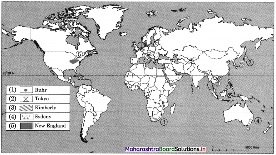
7. Show the following on a map of the world with suitable index

(1) Ruhr industrial region
(2) An industrial region in Japan
(3) An industrial region in South Africa
(4) An industrial region in Australia
(5) Industrial region near Great Lakes
Answer:
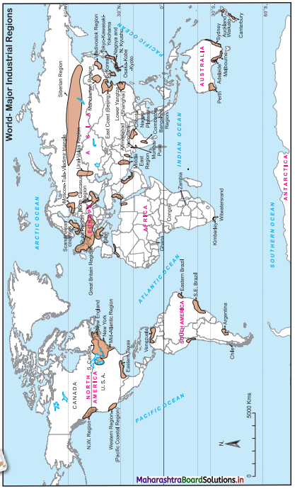
Maharashtra Board Class 12 Geography Solutions Chapter 5 Secondary Economic Activities 1

Class 12 Geography Chapter 5 Secondary Economic Activities Intext Questions and Answers

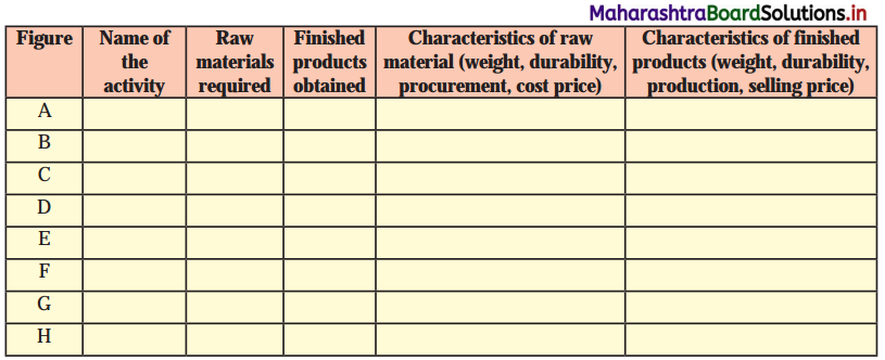
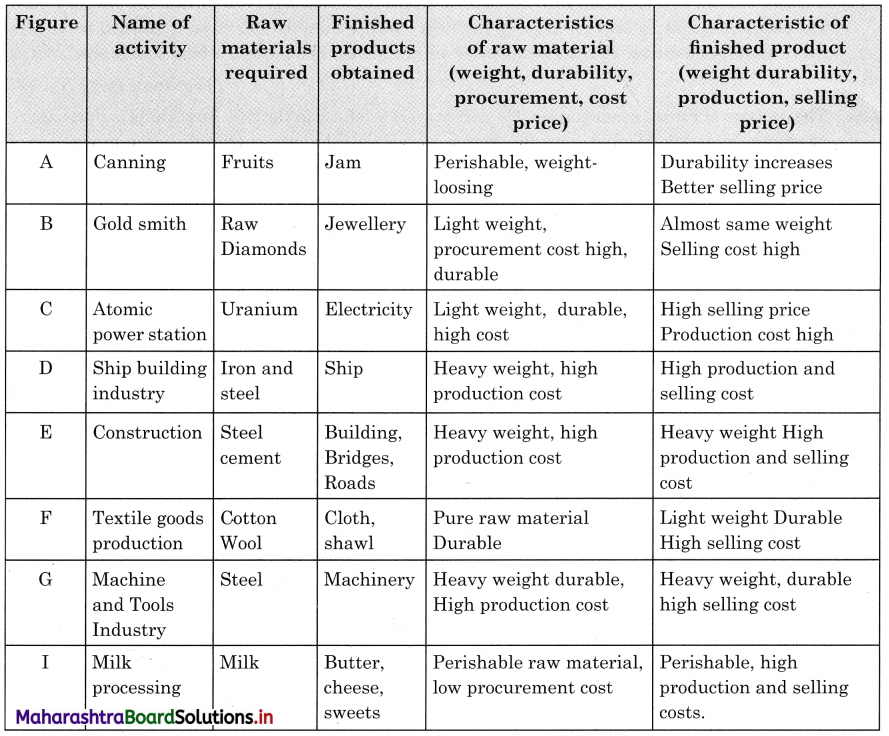
Observe the pictures given in the textbook figure. Identify the activities with which these figures are associated and complete the table.
Maharashtra Board Class 12 Geography Solutions Chapter 5 Secondary Economic Activities 2
Answer:
Maharashtra Board Class 12 Geography Solutions Chapter 5 Secondary Economic Activities 3

Try These

Question 1.
Look at the map of Solapur district. It shows the location of some sugar industries. Shamrao is a farmer at location A. He has just harvested his sugarcane crop. Study the map and tell where should he send his crop? What factors will Shamrao consider for this? (Textbook Page No. 43)
Answer:
(i) Shamrao has two options, he can sell his sugarcane to Pimpalner Sugar Factory or Virag Sugar Factory, since both the factories almost at equal distance from A.
(ii) The most important factor of consideration is the distance and perishability of sugarcane as a raw material.
(iii) Third factor he should take into consideration is from A, the road condition. The factory to which he should send sugarcane must be in good condition; so that sugarcane can be transported to industry as early as possible.

Maharashtra Board Class 12 Geography Solutions Chapter 5 Secondary Economic Activities

Question 2.
Firoz’s son has done an advanced course in Bakery Management from the nearby city. He wants his son to start a bakery in their village but his son says it should be in the city, which is around 20 kms from their village. Who is correct? Firoz or his son? Why? (Textbook Page No. 44)
Answer:
The decision of Firoz’s son is correct. He should start a bakery in the city. First thing is that bakery products are perishable and secondly there is loss of weight of raw materials in the production of bakery products.

Question 3.
Shantaram is a young boy from a tribal area in Maharashtra. He wants to start a honey processing unit as he has access to good honeycombs in the forest. The city is around 35 kms away. He has his own land in the village and is also getting land in the cit3\ Where should he establish the honey factory? In the village or in the city? Why? (Textbook Page No. 44)
Answer:
(i) Shantaram should start his honey factory in the city. Raw material in his factory will be honeycombs.
(ii) From honeycombs he will get two finished products – honey and wax. The weight of honeycombs after extracting honey and wax will be the same and therefore ideal location is city.

Can you tell?

Question 1.
Find example of market-oriented industries. (Textbook Page No. 45)
Answer:
(i) All textile industries are market-oriented industries Cotton Textile, Silk Textile, Woollen Textile.
(ii) All assembly industries are market-oriented industries Automobile, Air-craft, shipbuilding industries.

Use your brain power!

Question 1.
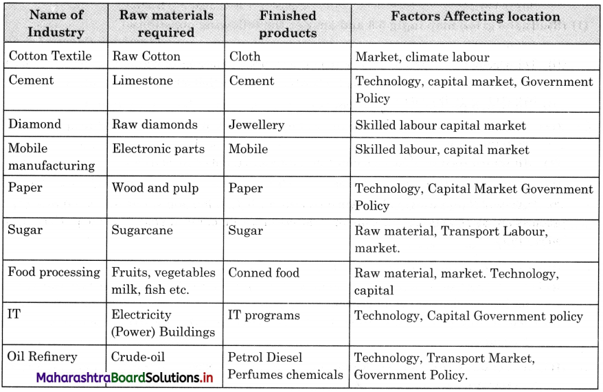
Following is a list of few industries. Think about the factors of location of these industries and tell whether they are footloose industries or not. Complete the table accordingly. (Textbook Page No. 47)
(i) Cotton textile industries
(ii) Cement industries
(iii) Diamond industries
(iv) Mobile manufacturing units
(v) Paper industry
(vi) Sugar industry
(vii) Food processing industry
(viii) IT (Hardware) industry
(ix) Oil refinery
(x) Hairpins industry
Answer:
Maharashtra Board Class 12 Geography Solutions Chapter 5 Secondary Economic Activities 4

Question 2.
(i) Refer to the lumbering map of the world in fig. 4.1 and 5.1, tell which industries will be located in the northernmost island of Japan?
(ii) How have the Great Lakes been instrumented in development of industrial regions in the USA?
(iii) How has the Trans-Siberian Railway contributed to the development of industries in Russia? (Textbook Page No. 51)
Answer:
(i) Paper and pulp industry.
(ii) The Great Lakes have been instrumented in the development of industrial regions in the USA through concentration of minerals and coal producing areas, local market, capital and technological development.

(iii) The Trans-Siberian Railway contributed to the development of industries in Russia is

  • Trans-Siberian Railway is the longest railway system connecting Petersburg in Western Russia to Vladivostok on the pacific coast.
  • This railway connects all major cities in Russia.
  • It passes through major iron-ore and coal producing areas, which has helped to the development of iron and steel industry in Russia.
  • This railway line helped for the movement of raw material and finished goods.
  • Therefore, many industries have been developed along this railway route.
  • It has also helped the movement of passenger and goods traffic in East-West direction.

Maharashtra Board Class 12 Geography Solutions Chapter 5 Secondary Economic Activities

Make friends with maps!

Question 1.
Study the given map in fig 5.3 and answer the following questions. (Textbook Pages 47 & 48)
Maharashtra Board Class 12 Geography Solutions Chapter 5 Secondary Economic Activities 5
(i) In which hemisphere do you find more concentration of industries?
(ii) In which part of North America has the industrial region been mainly developed?
(iii) In which part of Europe is concentration of industries mainly found?
(iv) Why is less industrial development found in other parts of African continent except coastal areas?
(v) In which part of India do you find concentration of industries?
(vi) Why do you think coastal areas have higher concentration industries?
(vii) Write a concluding paragraph on latitudinal distribution of industries in the world.
Answer:
(i) Northern Hemisphere.
(ii) North eastern Region.
(iii) North western, South and Central part
(iv) Dense forest, deserts, mountains, grasslands in other parts of African continent are responsible for less development of industries.
(v) Portal cities like Mumbai, Chennai, Kolkata and other areas like Delhi, Bangalore, Chota Nagpur etc.

(vi) Coastal areas have better ports and inland water transport facilities. Even road and rail transport are well developed.

  • Extensive level land.
  • Industries which depend on imported raw material like oil prefer to develop on coastal areas.
  • Industries which need humid climate develop in coastal areas for example textile industry.

(vii) Major industrial regions are concentrated in Northern Hemisphere in the latitudinal belt of 30° North to 50° North latitudes. However, there is an exception of Siberian industrial region in Russia.

  • North America, major European countries, Japan, China and parts of Russia falls in this latitudinal belt.
  • Major cause of the development of industries in this latitudinal belt is the Industrial Revolution in Europe.
  • In this region both mineral based and agro-based industries have developed.
  • Development of science and technology, skilled labour, well developed transportation facilities, high standard of living and extensive local market in this latitudinal belt are the other factors responsible for the development of industries.
  • However, outside this major industrial belt in Northern Hemisphere* only exception is India, industries have developed in latitudinal belt 8° North to 20° North.
  • Even in Southern Hemisphere industries have developed in the same latitudinal belt i.e. 30° South to 50° South latitudinal belt in South Africa, South America and South Australia.

Maharashtra Board Class 12 Geography Solutions Chapter 5 Secondary Economic Activities

Give it a try

Question 1.
Look at the given logo. Find out more information about it and write a short note on it. (Textbook Page No. 53)
Answer:
Digital India.
(i) Digital India is a campaign launched by the Government of India in order to ensure the government’s services are made available to citizens electronically by improved online infrastructure and by increasing internet connectivity or making the country digitally empowered in the field of technology.
(ii) The initiative includes plans to connect rural India with high speed internet networks.
(iii) Digital India consists of secure and stable digital infrastructure, delivering government services digitally and universal digital literacy.

Make in India:
On 25 September 2014, the Government of India launched a movement ‘Make in India’, like Swadeshi movement, for 25 sectors of Indian Economy. The main purpose to start this movement was to provide encouragement to businessmen in India to set up companies to manufacture their products in India and to investment more for the same.

In line with make in India, individual states too launched their own local initiative, such as ‘Magnetic Maharashtra’, ‘Make in Odisha’, Vibrant Gujarat, etc.

Startup India
(i) Startup India is an initiative of the government of India was first announce by Indian Prime minister, Narendra Modi during his 15 August 2015 address from the Red Fort in New Delhi.

(ii) The action plan of this initiative is focussing on three areas:

  • Simplification and Handholding.
  • Funding support and incentives.
  • Industry-Academia partnership incubation.

(iii) An additional area relating to this initiative is to discard restrictive state Government Policies within this domain, such an ‘License Raj’, Land permissions, Foreign Investment Proposals, and Environmental clearance. It was organised by Department for promotion of industry and internal trade.

Maharashtra Board Class 12 Geography Solutions Chapter 5 Secondary Economic Activities

Question 2.
Find at least 2 examples of each of the types of industries from India.
Answer:
(i) Industries in Digital India are:
DigiLocker-
DigiLocker is an online service provided by the government wherein any Aadhar card holder can access a cloud with their authentic documents/certificates. For example, driving license, vehicle registration, academic mark sheet etc.

MyGov-
MyGov is an initiative started by the Indian government to engage citizens in governance. The portal can be accessed via a website or a dedicated mobile app.

(ii) Industries in Startup India are:
Zomato:
Zomato is an Indian restaurant aggregator and food delivery startup that was launched in 2008. It is one of the most successful food tech startups.

Paytm:
It is an Indian e-commerce payment system based in Noida. It was founded in August 2010.

Ola Cabs:
It is founded in 2010 and giving tough competition to Uber.

(iii) Industries in Make in India:
Make in India focuses on the following industries viz. Automobiles, Aviation, Biotechnology, Chemicals, Defence manufacturing, etc.

Maharashtra Board Class 12 Geography Solutions Chapter 3 Human Settlements and Land Use

Balbharti Maharashtra State Board Class 12 Geography Solutions Chapter 3 Human Settlements and Land Use Textbook Exercise Questions and Answers.

Maharashtra State Board Class 12 Geography Solutions Chapter 3 Human Settlements and Land Use

1. Identify the correct correlation.

A : Assertion R : Reasoning
Question 1.
A – Settlements can be of various types.
R – Various physical factors affect the growth of settlements.
(a) Only A is correct.
(b) Only R is correct.
(c) Both A and R are correct and R is the correct explanation of A.
(d) Both A and R are correct but R is not the correct explanation of A.
Answer:
(d) Both A and R are correct but R is not the correct explanation of A.

Maharashtra Board Class 12 Geography Solutions Chapter 3 Human Settlements and Land Use

Question 2.
A – When cities grow, their functions also grow.
R – Cities can have only one function.
(a) Only A is correct.
(b) Only R is correct.
(c) Both A and R are correct and R is the correct explanation of A.
(d) Both A and R are correct but R is not the correct explanation of A.
Answer:
(a) Only A is correct.

2. Give geographical reasons.

Question 1.
Not all rural settlements change into urban settlements.
Answer:

  • The area between rural and urban is called rural-urban fringe.
  • Villages are beyond the rural-urban fringe and cities have different land use pattern.
  • In villages, land is mainly used for agriculture and related activities such as permanent pasture, grazing land, miscellaneous tree crops and groves, fallow land etc.
  • In city areas land is mainly used for industries, residential purpose, recreation, transportation etc.
  • Since the villages are far away from the city, they maintain their distinct identity and do not change into urban settlement.

Question 2.
In rural settlements, land use is related to agriculture.
Answer:

  • Generally, the land in rural areas is used for agriculture and related activities.
  • The classification of the land use in rural areas is done according to the Land Records Department.
  • As per Land Records Department, the land in rural areas is mainly used for activities related to agriculture, such as some land is under permanent pastures and grazing lands or some under tree crops or culturable waste-land or fallow land etc.
  • Thus, all the above types of land use around the rural settlements are related to mainly agriculture.

Question 3.
Rural-urban fringe have the characteristics of both urban and rural settlements.
Answer:

  • The area between urban and rural areas is called rural-urban fringe.
  • It has the characteristics of both urban as well as rural areas, since it is a transition zone between the two.
  • Thus, in rural-urban fringe there is a mixture of urban-rural land use.
  • In some rural areas apart from the land use for agriculture, some agricultural land has been converted into residential and industrial uses.
  • The villages in rural fringe are partly affected by urbanization.
  • Thus, rural-urban fringe has the characteristics of both urban and rural settlements.

Question 4.
Growth of urban areas is linked to land use.
Answer:

  • Land use in urban areas is different from land use in rural areas.
  • In rural areas the land use is closely related to agricultural activities like cultivation of different crops, plantation of trees, permanent pastures, grazing land, cultivation of tree crops, fallow land etc.
  • On the other hand, land use in urban areas is varied and closely related to housing and economic activities.
  • As the population of the urban area increases, more and more non-agricultural activities develop in urban areas.
  • Growth of urban areas depends upon area under construction, industries, different types of institutions such as school, college, insurance companies, bank etc.
  • Recreational activities, transportation are the other urban land uses.
  • Thus, growth of urban areas is linked with land use.

Maharashtra Board Class 12 Geography Solutions Chapter 3 Human Settlements and Land Use

3. Write short notes on.

Question 1.
Interrelationship between urban and rural settlement.
Answer:

  • Settlements can be divided into urban and rural on the basis of their functions.
  • Rural settlements are smaller than urban settlements.
  • In rural areas agriculture and allied agricultural activities like livestock rearing, fishing, lumbering etc., are developed.
  • In urban areas, industries, construction and economic activities like trade, transport and communication, banking and insurance are the important activities.
  • The development industries need various raw material and services which are supplied by rural areas.
  • For example, cotton grown in rural areas is supplied to cotton textile industries in urban areas. Everyday many rural people commute to urban areas to work in different activities.
  • Thus, there is good interrelationship between urban and rural areas since they depend on each other.

Question 2.
Problems of urban settlements.
Answer:

  • Most of the urban areas have very large size of population and density of population is also very high.
  • When cities increase in size, many changes occur. These changes are related to land use and structure of the city.
  • The large size of population and high density create number of socio-economic, cultural, infrastructural, administrative and environmental problems.
  • The air, water and noise pollution, development of slums, traffic jam, overcrowding in trains and buses, waste disposal etc., are some of the serious problems in most of the urban settlements.

Question 3.
Suburbs
Answer:

  • In the outer part of the urban areas there are small towns or small cities, they are known as suburbs.
  • When big cities become overcrowded and overpopulated, the further development starts outside city area and thus suburbs develop.
  • For example, Dombivali, Kalyan, Ambarnath etc., are the suburbs of Mumbai.
  • Suburbs generally consists of residential housing and shops of low order, which act as central place for the local community.
  • Often, suburbs are the most recent growth of an urban area and their end marks the urban fringe.
  • With increase in population there is growth of suburb, the growth of suburbs may result in urban sprawl.

Question 4.
Mixed land use.
Answer:

  • Mixed land use is observed in some of the urban areas.
  • It is an area where different types of land use exist together.
  • In some cities residential, industrial, commercial, administrative functions are found in an integrated manner.
  • In many cities in developing countries one can find schools, clinics, houses, business shops at one place itself.
  • Generally mixed land use is found in cities which are growing very fast, because land in the city is not sufficient to reserve certain areas for certain land use, therefore there is mixed land use.

4. Answer the following questions in detail.

Question 1.
Explain the characteristics of rural settlement.
Answer:

  • On the basis of functions, settlements can be divided into two types – rural and urban.
  • Agriculture and allied agricultural activities like fishing, livestock rearing, lumbering etc., are most economic activities in rural areas.
  • The classification of land use in rural areas is done according to Land Records Department.
  • As per Land Records Department the land in rural areas is mainly used for activities related to agriculture, such as some land is under agriculture, some under permanent pastures and grazing lands or some under tree crops or culturable waste-land or fallow land etc.
  • Most of rural settlements are semi-clustered or fragmented and small in size.
  • Primary activities like agriculture, lumbering, fishing, livestock rearing is more developed in rural settlements.
  • In rural areas, sometimes agricultural areas are converted into residential or industrial areas.
  • Many people in rural areas daily commute to city areas for work, thus rural and urban areas are connected with each other.
  • There is an area between rural and urban area which is called rural-urban fringe, rural settlements are beyond the rural-urban fringe.

Question 2.
What factors are responsible for development of various patterns in settlement? Give examples.
Answer:
1. Patterns of settlements are affected by various physical factors like relief, soils, climate, availability of water supply etc.

2. Physical factors influence the type and spacing of settlements, which results into various patterns of settlements.

3. Type of soil and quality of soil are two important factors which affect rural settlements.

4. Fertile plains and valleys have thick, rich and fertile alluvial soil, which supports agriculture, so nucleated settlements develop in these areas. For example, most of the villages in Ganga plains have nucleated settlements.

5. Settlements develop as per the relief of that area. For example, Foothill settlements develop at the foot of mountain, hilltop settlements develop at the top of the hill. For example, hilltop settlement at Shimla or Manali.

6. In the areas of mountainous or hilly relief, due to inaccessibility, there are dispersed or isolated settlements. For example, dispersed or isolated settlements in Himalaya mountains.

7. Sometimes settlements develop along the coastline, canal, river, road, or railway line. They are in straight line; they are called linear settlements. For example, settlements along Konkan coastline and settlements along Mumbai-Pune road.

8. Climate also affects development of settlements. Areas of extreme climate are avoided by people. Therefore, such areas have dispersed settlements.

9. For example, due to extreme hot climate there are dispersed settlements in Rajasthan and due to extreme cold climate, there are isolated settlements in the polar regions.

10. Water is essential for human development. Therefore, many settlements develop around lakes or natural tanks, they are circular settlements.

11. Sometimes settlements develop at the confluence of two rivers, the settlements grow in all three sides, they are triangular settlements. For example, Karad town is on the confluence of Krishna and Koyna river.

12. Sometimes settlements grow around the mines, or any central object. This centre point provides source of livelihood to the people. Thus, radial pattern of settlement develops. For example, radial settlements around coal mines in the State of Bihar.

Maharashtra Board Class 12 Geography Solutions Chapter 3 Human Settlements and Land Use

5. Differentiate between.

Question 1.
Land Use and Land Cover
Answer:

Land Use Land Cover
(i) Land use describes the use of land by people for different activities, such as recreation, housing, agriculture, educational institutes etc. (i) Land cover describes the physical surface covering the land such as forest rock, ice, sand, water etc.
(ii) For example, in any city, people may use some land for housing, some for recreation, some for sports ground etc. (ii) For example, in any area land may be covered by natural factors such as vegetation, river, sand dune, snow covered mountain etc.
(iii) Land use may change from place to place depending upon type of land and need for the people. (iii) Land cover is natural factor it hardly changes unless man purposefully makes changes in it.
(iv) Land use cannot be studied by the satellite imagery alone. (iv) Land cover can be studied by satellite imagery.

Question 2.
Barren and Non-agricultural Land
Answer:

Barren Land Non-agricultural Land
(i) The land which is not used for any human activity is called barren land. In other words, it is wasteland. (i) The land which is used by man for various human activities except agricultural activity, is called as non-agricultural land.
(ii) For example, hilly or mountainous land, desert land, ravines, swampy and marshy land etc. (ii) For example, land used for housing, industries, construction of roads, railways etc.
(iii) Generally barren land cannot be used for agriculture or other activities with available technology. (iii) Due to the development of secondary or tertiary activities there is increase in the used of non-agricultural land.

Question 3.
Radial pattern and Circular Pattern
Answer:

Radial Pattern Circular Pattern
(i) In radial pattern settlements grow around certain object. (i) In circular pattern settlements grow around water body.
(ii) They develop near temple or a centre of commercial activity. (ii) They develop near lake or natural tank.
(iii) For example, settlements near Vindhyachal in Uttar Pradesh. (iii) For example, settlements around Nainital lake in Uttarakhand.

Question 4.
Nucleated and Dispersed Settlement
Answer:

Nucleated Settlement Dispersed Settlement
(i) Settlement where buildings or houses are grouped or clustered around a central point or nucleus is known as nucleated settlements. (i) Settlement where buildings or houses are scattered or dispersed, is known as dispersed settlement.
(ii) Houses or buildings are very close to each other. There may be common wall between two houses. (ii) Houses or buildings are far from each other. One house may be at a distance of half a kilometre from the other.
(iii) Geographical factors are favourable such as spring or fertile river valley. (iii) Geographical factors are not favourable such as extreme climate, barren land etc.
(iv) For example, settlements in river valleys. (vi) For example, settlements in the desert of Rajasthan.

6. Draw a neat and labelled diagram

(1) Linear settlement
(2) Radial settlement
(3) Compact settlement
(4) Dispersed settlement
Answer:
Maharashtra Board Class 12 Geography Solutions Chapter 3 Human Settlements and Land Use 1

Maharashtra Board Class 12 Geography Solutions Chapter 3 Human Settlements and Land Use

7. Write a note in your own words about how land used in Lonar city has evolved. Refer the map on textbook page no. 30.

Maharashtra Board Class 12 Geography Solutions Chapter 3 Human Settlements and Land Use 2
Answer:

  • Two maps of Lonar city are given. One map is of the year 2005-06 and another is of 2015-16.
  • These two maps show the changes in land use that have taken place in the span of 10 years.
  • The following changes have been registered.
  • There is no change in the size of Lonar lake.
  • The area occupied by Lonar city has increased substantially.
  • Forest area around the lake has increased.
  • An area under waste land/ scrubs have increased.
  • Around the temple in the southeast, on the waste scrub land a new rural hospital, government hostel, government ITI, Tahsil office etc., has been developed. This newly developed area has been named as Krishna Nagar, which is not in 2005-06 map.
  • To the north-east of the Lonar city two more building have been constructed. One is central public school and another is civil and criminal court.
  • To the south of the temple in the heart of Lonar city built up residential area is spreading over built up residential sparse.
  • Overall built up residential sparse is increasing in all directions around Lonar lake and south-eat of the Lonar city and thus there is encroachment over agricultural land.

8. Read the given passage and answer the following questions.

Different types of human settlements include hamlets, villages, small towns, large towns, isolated places, cities and conurbations. In some systems, types of human settlements are broken up into urban, suburban and rural; for example, the U.S. Census Bureau divides settlements into urban or rural categories based on precise definitions. Small settlements, such as hamlets and villages, have low populations and restricted access to services, larger types of settlements, such as cities, have higher populations, higher densities and greater access to services.

For example, a village may have only one or two general stores, while a large metropolis may have many specialized stores and chain stores. These differences are known as low-order service settlements and high-order service settlements. Larger settlements also have a sphere of influence affecting surrounding settlements. Settlements may also be divided by the site chosen, such as sites selected based on resources, trading points, defensive sites, shelter and relationship to water resources. The functions of human settlements also differ, as settlements may be established as ports, market towns and resorts. Types of rural settlements may also be classified by function, such as proximity to farming, fishing and mining. Settlements that focus on one economic activity are called single functional settlements. Human settlements may be permanent or temporary. For example, a refugee camp is a temporary settlement, while a city is a permanent settlement.

Question 1.
Which human settlements are mentioned in the passage above?
Answer:
Hamlets, villages, small towns, large towns, isolated places, cities and conurbations are the types of settlements mentioned in the passage.

Question 2.
On what basis are urban and rural areas classified?
Answer:
Settlement are classified on the basis of the size of population, density, access to higher order and lower order services, site chosen, functions, permanent or temporary etc.

Maharashtra Board Class 12 Geography Solutions Chapter 3 Human Settlements and Land Use

Question 3.
What are the functions carried out in rural settlement?
Answer:
Functions carried out in rural settlements are farming, fishing, mining, one or two general stores, etc.

Question 4.
Explain the difference between low-order services and higher order service settlements.
Answer:

  • The hamlets and villages have low population and restricted access to lower order services.
    For example, a village may have only one or two general stores. They are called low order settlements.
  • Large metropolitan cities have higher population, higher density and greater services of higher order.
  • For example, large metropolitans may have chain stores, malls, departmental stores, super markets etc. They are called higher order settlements.

Class 12 Geography Chapter 3 Human Settlements and Land Use Intext Questions and Answers

Try These

Question 1.
Observe Fig 3.2 A to F (Textbook Page No. 22-23). They show various patterns of settlements. Try to understand the difference between them. Carefully read their characteristics in the second column. According to the applicable characteristics, write alphabet of the image settlement in the place provided below characteristics.
Answer:

Satellite image of the settlements Characteristics of settlements
Photo A C
Photo B A
Photo C F
Photo D E
Photo E D
Photo F B

Question 2.
Can you identify problems faced by your city/town/village in terms of any of the following? (Textbook Page No. 27)

Types of problems Problems / Issues
1. Economic
2. Social
3. Cultural
4. Environmental
5. Infrastructural
6. Governance and Administrative
7. Others

Answer:

Types of problems Problems / Issues
1. Economic Unemployment and poverty
2. Social Religious conflicts and tension in society
3. Cultural Commercialisation of festivals
4. Environmental Air, water and noise pollution
5. Infrastructural Inadequate roads, bridges and public transport
6. Governance and Administrative Increase in crime rate and bribery
7. Others Overcrowding, traffic jam, housing problem

Maharashtra Board Class 12 Geography Solutions Chapter 3 Human Settlements and Land Use

Make friends with maps!

Question 1.
See map of Ichalkaranji city (Textbook Page No. 28) and observe how changes have occurred in the city over the years. Answer the questions that follow.
(i) Enlist the colours used for showing land uses in the index.
(ii) What do the blue and black lines show?
(iii) What is the name of the river in the map?
(iv) Name any two villages shown on the map.
(v) Which city is shown on the map?
(vi) Which periods do the map belongs to?
(vii) Which land covers have reduced? What are their colours?
(viii)Which landcovers seen to have increased? what are their colours?
(ix) Which land cover has been replaced by increased landcovers?
(x) Write a conclusive note comparing both the maps.
Answer:
(i)

  • Yellow for agriculture
  • Green for forest
  • Pink for residential land use
  • Dark blue for industrial land use
  • Dark green for recreation
  • Brown for mining/ quarry
  • Violet for public/semi public

(ii) Blue lines show rivers and black lines show roads.

(iii) Panchaganaga river

(iv) Jambhali and Haroli villages

(v) Ichalkaranji

(vi) 2007 and 2017

(vii) Open space-dark green colour, forest – light green colour, wasteland – light violet colour residential sparse – light orange

(viii) Following landcovers have increased landcover for residential area – colour pink, Landcover for industrial area colour dark blue

(ix) Following land cover have been replaced by increased landcovers. Residential sparse areas are replaced by residential built up land use, open space is replaced by residential built up area and wastelands are replaced by industries.

(x) Map A shows land use and land cover map of Ichalkaranji city in the year 2007.

  • Map B shows land use and land cover map of Ichalkaranji city in the year 2017.
  • Both the maps show that there is land use for agriculture, industries, transportation, residential purpose, recreational purpose, mining around the city, village settlements etc.
  • In both the maps there is land is covered by Forest, waterbodies, wasteland/ scrubs, Panchaganaga river etc.
  • The landcover in 2017 as compared to landcover in 2007 have been reduced for forest, residential sparse, open space and wasteland.
  • The landcover in 2017 as compared to landcover in 2007 have been increased for industries and built up residential areas.
  • Residential sparse areas are replaced by residential built up land use, open space is replaced by residential built up area and wasteland are replaced by industries.

Can you tell? (Textbook Page No. 27)

You know what is urban and what is rural. What will you call the area that lies between them?
Answer:

  • The area between urban and rural areas is called rural-urban fringe.
  • It is characterised by the urban as well as rural characteristics, since it is transition zone between the two.
  • Thus, in rural-urban fringe there is a mixture of urban-rural land use.
  • In some rural areas apart from the land use for agriculture, some agricultural land has been converted into residential and industrial uses.
  • Thus, villages in rural fringe are partly affected by urbanization.
  • Thus rural-urban and fringe have the characteristics of both urban and rural settlements.

Maharashtra Board Class 12 Geography Solutions Chapter 3 Human Settlements and Land Use

Find out (Textbook Page No. 27)

Compare the cover page of Std. XII text book with Std. XI geography text book. Discuss and write a short paragraph about changes in land use / land cover in your own words.
Answer:
Geography Cover Page (Textbook of standard XI)

  • Depicts the natural landscape.
  • There are two snow covered mountains peaks and rivers having their source in these mountains.
  • At the foot of the mountain there is fan shape deposit of silt.
  • The river has developed number of meanders and an ox-bow lake.
  • The slope of the mountains is covered with coniferous forest and on the lower ground at the foot of the mountain there is mixed forest.
  • There is a sandy beach. Along the beach there are coconut trees.

Geography Cover Page (Textbook of standard XII)

  • Depicts cultural/man made development super imposed on natural landscape.
  • A quarry is developed at the foot of mountain.
  • There is deforestation and development of two villages and a town on the right bank of the river.
  • On this bank of river there is development of industry as well.
  • Number of multi-story building have come up on the left bank of the river including a mall and hospital.
  • Power line, concrete road and railway have developed in the last 10 years.
  • On the beach hotels, rest houses, sport activities have been developed for tourists and therefore number of tourists are seen on the beach.
  • The natural landscape on cover of the textbook of Std. XI changes into cultural landscape on the cover page of geography textbook of Std. XII.

Let’s recall (Textbook Page No. 24)

Can you differentiate between urban and rural settlements?
Answer:

  • On the basis of functions, settlements are divided into two types – rural settlement and urban settlement.
  • There is difference in land use in rural and urban settlements.
  • In rural areas the land use is closely related to agricultural activities like cultivation of different crops, plantation of trees, permanent pastures, grazing land, cultivation of tree crops, fallow land etc.
  • Where as in urban areas land use is for industries, construction and economic activities like trade, transport and communication, banking and insurance etc.
  • Urban settlements are large and compact, since population is more compared to available land.
  • Rural settlements are small and dispersed, since population is less compared to available land.

Think about it (Textbook Page No. 24)

Can a town have only one function? Why do the cities become multi-functional?
Answer:
1. Towns do not have only one function.

2. Some towns have one important and major function. They are known by that function. But they have many other functions also. For example, Shirdi in Maharashtra is known for religious function but it has other functions like tourism, education, commercial etc.

3. Cities become multifunctional as they grow. With increase in population demand for various functions increases. As cities grow in size many changes occur and therefore land use also changes.

4. For example, when any city develops as industrial centre, its main function is industries. But as people start coming to that city for employment opportunities, the city grows. Then other functions like educational institutes, business centres, recreational centres, etc., functions develop to fulfil the needs of increasing population. Thus, cities become multi-functional.

Maharashtra Board Class 12 Geography Solutions Chapter 3 Human Settlements and Land Use

Question 1.
Observe Fig. (Textbook Page No. 21) and answer the following questions.
Maharashtra Board Class 12 Geography Solutions Chapter 3 Human Settlements and Land Use 3
(i) Where are humans’ settlements likely to develop: A, B, C, D or E? Why?
(ii) In the above figure in which place human settlement is not likely to develop? Why?
(iii) Looking at the figure above, what factor do you think could contribute to the development of human settlements?
(iv) Can economic factors be important along with physical factors for the development of human settlements?
(v) Do physical factors affect the economic activity of human settlements?
(vi) Make a list of factors which affect development of settlements in an area.
Answer:
(i) Human settlement is likely to develop at C and D.
The most important factor responsible for the development of settlement is river. Hence, agriculture seems to be the most important activity and development of agriculture needs fertile soil and water supply which is readily available here.

(ii) Human settlement is not likely to develop at A and B. This is because of steep slope and rugged terrain.

(iii) The most important factors that could contribute to the development of human settlements are availability of water from the river and fertile soil on the bank of river.

(iv) Yes, economic factors are equally important along with physical factors for the development of human settlements. For example, industries need development of roads to carry raw material or agriculture also needs development of roads. Many settlements are developed along roads or railway lines.

(v) Yes, physical factors affect the economic activity in the development of human settlement. For example, agriculture is’ an important activity which is affected by relief and water supply. It can be developed where fertile soil and sufficient water supply is available.

(vi) The factors which affect development of settlements are relief, terrain, climate, soil, water supply, altitude, drainage, minerals etc.

Question 2.
Visit http://censusindia.gov.in/2011-prov-results/paper2/data_files/India2/1.%20Data%20 Highlight.pdf to know how cities are divided into various types in India on the basis of their populations. Also look for examples from Maharashtra. Refer to the website and complete the table as given below : (Textbook Page No. 24)
Answer:

Classification Population
Class I 100,00 and above
Class II 50,000 to 99,999
Class III 20,000 to 49,999
Class IV 10,000 to 19,999
Class V 5,000 to 9,999
Class VI Less than 5000

Question 3.
On the basis of dominant or specialised functions, Indian cities and towns can be broadly classified as follows. Complete the following table with examples from Maharashtra and India. (Textbook Page No. 24)
Answer:

Function Name of city in Maharashtra Name of cities outside Maharashtra
Administrative Nashik Gandhinagar
Industrial Chinchwad Jamshedpur
Transport Nagpur Bengaluru
Commercial Mumbai Surat
Mining Chandrapur Balaghat
Cantonment Khadki Agra
Educational Pune Kota
Religious Pandarpur Varanasi
Tourism Matheran Ooty


Maharashtra Board Class 12 Geography Solutions Chapter 6 Tertiary Economic Activities

Balbharti Maharashtra State Board Class 12 Geography Solutions Chapter 6 Tertiary Economic Activities Textbook Exercise Questions and Answers.

Maharashtra State Board Class 12 Geography Solutions Chapter 6 Tertiary Economic Activities

1. Complete the Chain

Question 1.

A B C
(1) Matheran (1) Tea (1) Communication
(2) GPS (2) Atlantic Ocean (2) Tertiary Activity
(3) Sri Lanka (3) Satellite (3) Export
(4) Panama Canal (4) Tourism (4) Pacific Ocean

Answer:

A B C
(1) Matheran (1) Tourism (1) Tertiary Activity
(2) GPS (2) Satellite (2) Communication
(3) Sri Lanka (3) Tea (3) Export
(4) Panama Canal (4) Atlantic Ocean (4) Pacific Ocean

Maharashtra Board Class 12 Geography Solutions Chapter 6 Tertiary Economic Activities

2. Choose the correct option.

Question 1.
Tertiary activities include
(a) Use of natural resources
(b) Finished product
(c) Raw material
(d) Transportation
Answer:
(d) Transportation

Question 2.
Natural ports
(a) Kochi
(b) JNPT
(c) Delhi International Terminal
(d) Nagpur Cargo Hub (MIHAN)
Answer:
(a) Kochi

Question 3.
Trans-Australian Railway connects
(a) Perth – Sydney
(b) Perth – Vladivostok
(c) Sydney – Vancouver
(d) Vancouver – Vladivostok
Answer:
(b) Perth – Vladivostok

3. Give geographical reasons.

Question 1.
Tertiary activities include both services and exchapge.
Answer:

  • Transportation, communication, trade and commerce are the main tertiary activities.
  • Road, rail and airways are the important modes of transportation, which help in exchange of goods and services. Therefore, it is a service activity.
  • Transportation provides facilities for the movement of goods from areas of surplus to areas of scarcity produced in primary and secondary activities.
  • Credit facilities, banking facilities, marketing are also tertiary activities, they provide services to people.
  • Postal services, shopkeepers, vegetable sellers, fruit sellers, etc., are also included in service activities.

Question 2.
The proportion of airways as means of transportation is increasing.
Answer:

  • Air transport is an important enabler to achieve economic growth and development.
  • In the global world, there is exchange of goods between countries. Therefore, there is more use of air transport to carry perishable, valuable and light goods from surplus areas to scarcity areas.
  • It facilitates integration into global economy and provides vital connectivity on a national, regional and international scale.
  • Nowadays tourism is the fastest growing industry; air transport is more used for international tourism.
  • Therefore, the proportion of airways as means of transportation is increasing.

Maharashtra Board Class 12 Geography Solutions Chapter 6 Tertiary Economic Activities

Question 3.
Geographical diversity is responsible for trade to occur.
Answer:

  • The geographical diversity is the set of physical, human and cultural elements differentiated from each other that converge in the relatively small geographic space that is part of the same zone, region or country.
  • If you take into consideration natural regions of the world, each region is different from another.
  • The natural resource available in one country will be different from the ones available in different regions.
  • There is variation in climate, soil, minerals, forest, relief, water supply etc.
  • Depending upon the availability of geographical factors, there is specialisation of certain economic activities in certain areas and there is trade from surplus areas to scarcity areas. For example, in one region, plenty of oil is available while in another region no oil reserves are available.
  • This variation in distribution of oil will be responsible for the development of trade between oil rich and oil poor countries.
  • Thus, geographical diversity is responsible for trade to occur.

4. Write short notes on.

Question 1.
Importance of satellite as means of communication.
Answer:

  • A communications satellite is an artificial satellite that relays and amplifies radio telecommunication signals via. transponder.
  • Communications satellites are used for television, telephone, radio, internet and military applications.
  • The information about physical and human factors is obtained from satellite communication.
  • Satellite communication is used in remote islands, in some countries and continents where landline telecommunication is rare or not available.
  • As television becomes the main market, its demand for satellite communication becomes very important.
  • Satellites are also used for internet communication, military communications, etc.
  • Thus, importance of satellite as means of communication is increasing.

Question 2.
Role of transportation in trade.
Answer:

  • Transport support trade and industry in carrying raw material to the place of production and distribution of finished products for consumption.
  • Transport means to make goods available to consumers.
  • Transport makes possible movement of goods from one place to another with great ease and speed.
  • Trade means exchange of goods and services. In trade there is movement of goods from surplus areas to scarcity areas. The movement of goods is possible only because of transport.
  • In other words, without the help of transport development of trade is not possible.
  • Thus, transport plays an important role in economic development and globalisation of trade.

Question 3.
Tourism and GDP.
Answer:

  • Tourism is vital for the success of many economies around the world.
  • Tourism boosts the revenue of the economy, creates thousands of jobs and develops the infrastructures of the country.
  • It also creates jobs in agriculture, communication, health and educational sectors.
  • The government that depends on tourism, invests a lot in the infrastructure of the country. They construct new roads and highways, develop parks, improve public places, and set up airports, etc.
  • With augmenting facilities, more and more tourists are attracted in such countries, thus, there is boosting of the GDP.

5. Differentiate between.

Question 1.
Secondary Economic Activities and Tertiary Economic Activities
Answer:

Secondary Economic Activities Tertiary Economic Activities
(i) Secondary activities are concerned with activities adding value to already existing products from primary activities. (i) Tertiary activities are concerned with providing services rather than providing material goods.
(ii) Development of secondary activities depends upon the production of resources in primary activities. (ii) Development of tertiary activities depends upon the development of secondary activities.
(iii) Manufacturing and construction are important secondary activities. (iii) Trade, transport communication, banking, insurance, etc., are tertiary activities.
(iv) Secondary activities produce goods and commodities. (iv) Tertiary activities help reach these goods and commodities to the consumers.
(v) Secondary activities may be away from the market and settlement. (v) Tertiary activities are always near the market and settlement.

Maharashtra Board Class 12 Geography Solutions Chapter 6 Tertiary Economic Activities

Question 2.
Quaternary Activities and Quinary Activities
Answer:

Quaternary Activities Quinary Activities
(i) Quaternary activities refer to those activities where the task is to think, research and develop ideas. (i) Quinary activities involve work related to administration.
(ii) Confined to research, training and education. (ii) Confined to the highest-level decision taking and policy making.
(iii) Software developers, statisticians, hospital  staff, teachers, financial planners tax consultants, people working in theatres, etc., comes under quaternary activities. (iii) Senior business executives, government officials, scientists, judges, etc., comes under quinary activities.

Question 3.
Waterways and Airways
Answer:

Waterways Airways
(i) Development of water transport needs courted area with broken coastlines. (i) Development of airways needs favourable climate, advance technology and plain land for airports.
(ii) This is the cheapest mode of transport. (ii) This is an expensive mode of transport.
(iii) Heavy and bulky goods are transported, e.g., minerals, oil, coal, machinery, etc. (iii) Light, perishable and expensive goods are transported, e.g., electronic goods, gold, silver, fish, dairy products, etc.
(iv) Slow mode of transportation. (iv) Fast mode of transportation.
(v) More used for goods transport than passengers’ transport (v) More used for passengers’ transport than for goods transport.

6. Answer in Detail

Question 1.
Explain the factors affecting trade between two countries.
Answer:
Trade refers to transfer of goods or services from one person to another or from one country to another. Factors which affect the trade are natural resources, climate, population, culture, economic cost, specialization, etc.

Natural resources : Distribution of natural resources is uneven. The natural resources available in one country differs from another. Because of this uneven distribution of resource, there is trade between resources surplus and resource deficit.

Climate : Climate mainly affects the plants and animals in a region. In the areas of different climate, there are different types of plants and animals. Example, in the tropical countries like Sri Lanka whose major export is tea or Malaysia and Indonesia, whose major export is rubber. This occurs naturally because of favourable climate for growing tea and rubber plants in these countries.

Population : Population size, distribution and density are different in different countries. This leads to difference in production and consumption and hence trade occurs.

Standard of living can also determine the demand for various goods and services. The country with less population depends more on trade because fewer human resources is engaged in production of goods.

Culture : Some countries are known for their specific art and craft, based on their culture, specific production of goods which have worldwide market, for e.g., Kashmiri shawls or Iranian carpets.

Economic Cost : Cost of production is the major factor in the process of production. It is cheaper to import certain goods than producing it in the country itself. For example, it is cheaper to import tea from India and Sri Lanka than producing it in England.

Specialisation : Due extremely favourable factors of production, some countries have specialisation for certain goods and they have name and fame in the world market, so they develop export trade. For example, watches of Switzerland or electronic goods of Japan or tender beef of Argentina.

Government Policy: Government policy about export or import affects trade. For example, Government may increase import duties of some goods, to encourage people to buy domestic goods. Thus, import trade of those goods goes down.

Maharashtra Board Class 12 Geography Solutions Chapter 6 Tertiary Economic Activities

Question 2.
Development of transportation is dependent on geographical factors. Explain.
Answer:

  • Various geographical factors affect the development of transport.
  • Relief, climate and location are the three most important factors that affect the development of transportation.
  • It is easier to build roadways and railways in plain areas.
  • Dense forests, hilly and mountainous regions affect the construction of roads and railways, in Africa and South America.
  • Coastal location with broken coast lines is favourable for development of ports and harbours.
  • For the development of airways; favourable climate and plain region for construction of airports are essential.
  • Foggy and smoggy weather and high peaks will be obstacles for the development of air transport.

Question 3.
Why is transportation system important in the development of any nation?
Answer:

  • Transportation plays important role in rapid economic growth of a nation.
  • The introduction of railways has been historically the most important and powerful single factor in the process of economic development of industrial nations of the world like USA, France, Germany, Japan, etc.
  • The significance of transportation in economic activity is found in its effects on both human wants and satisfaction of wants through production and distribution of goods.
  • Transportation increases the quality and variety of consumer goods, thereby stimulating the demand and development of trade and economy of the nation.
  • Transport provides various employment opportunities and boosts up the economy of the country. For example, many people got employment in construction work of Metro rail track.

Question 4.
Tertiary activities are expanding day-by-day. Explain the statement.
Answer:

  • Tertiary activities act as the link between primary and secondary activities.
  • These activities are mostly in the form of services.
  • Tertiary activities include transport and communication, trade, loading and unloading of goods, banking, insurance, marketing, export, etc.
  • Providing public services like hospital, education, research and development, administration, etc., are also included in tertiary activities.
  • With increasing industrialisation population growth and trade, number of people working in banking, insurance, tax consultants, software developers, teachers, etc., went on expanding day by day.

7. On an outline map of the world, show the following with the help of suitable index

(1) A canal bringing radical changes in sea transport.
(2) Railway connecting two continents.
(3) An international airport in India.
(4) An important port in India.
Answer:
Maharashtra Board Class 12 Geography Solutions Chapter 6 Tertiary Economic Activities 1

Maharashtra Board Class 12 Geography Solutions Chapter 6 Tertiary Economic Activities

8. Read the given passage and answer the following questions

Careful planning and implementation is necessary for economic development of any country. In the tourism sector the need for planned development is of great importance. It involves many industries working together in a complex way and needs special attention. Planning basically tries to allot limited resources between various competitors with a view to maximize output, income and employment and to make sure different sectors have fair growth. Tourism planning is a process through which the set goals can be achieved and the various choices linked to tourism development can be addressed. It is a long term and constant process of preparing, upgrading and improving a destination for tourist.

Communities are the basic elements of tourism. It mainly depends upon the level of acceptance shown by local communities. In the process of planning their involvement is essential. The development of tourism creates impact on mainly environment, socio-culture and economy of the host community at any destination. These impacts produce both negative as well as positive impacts. Planning is necessary to reduce the negative impact and boost the positive impact for sustainable development of a destination.

Question 1.
Why does the tourism sector need planning?
Answer:
Plan development in the tourist sector is of great importance, since it involves many industries working together in a complex and hence special attention.

Planning will help to allot limited resources between various competitors with view to maximise output, income and-employment.

Question 2.
What is the importance of communities in planning?
Answer:

  • In the process of planning communities are basic elements of tourism.
  • It mainly depends upon level of acceptance shown by local communities.
  • In the process of planning their involvement is necessary and therefore, community planning is necessary.

Question 3.
Explain any two benefits of planning.
Answer:
Planning reduces the negative impact and boosts the positive impact for sustainable development of a destination.

Question 4.
What factors affect the economy of the host community?
Answer:
The development of tourism creates impact on mainly environment socio-culture and economy and economy of host community at any destination.

Question 5.
Why planning is a long-term task?
Answer:
Planning is a long-term task because planning is a constant process of preparing, upgrading and improving a destination for tourists.

Maharashtra Board Class 12 Geography Solutions Chapter 6 Tertiary Economic Activities

Class 12 Geography Chapter 6 Tertiary Economic Activities Intext Questions and Answers

Think about it.

Read the following comprehension and answer the questions that follow:

There are three friends from different back-grounds. They decided to become entrepreneurs after graduating from the same college. Rohit is a farmer’s son. He pursued his bachelor degree in the Arts faculty. He was thinking of continuing his father’s profession but at a different level. He wanted to grow export-quality agricultural products in his two acres of farmland.

Sejal is the daughter of a businessman. They produce and sell bakery products on a wholesale basis. She has passed her degree in Science. She wants to become an entrepreneur in Fast Moving Consumer Goods (FMCG) products. Asif is a son of a small hotel owner. He has passed his graduation in Event Management. He wants to start his own company of Event Management.

After graduating with good grades, they decided to help each other and begin their careers. Rohit, Sejal and Asif tried to find out information about haw to start their businesses. They tried to get maximum information regarding their businesses. They wanted to plan, organise and then establish their start¬ups. During this period, they found information regarding their businesses.

Rohit found out that he will have to do major changes in his farmland to grow export-quality products like lily, orchid flowers and fruits like kiwis, dragon fruits, etc. He will have to maintain moisture and temperature in the air. He will also need to use special fertilizers to maintain the soil’s pH value.

He also came to know that he has to take help of the Agricultural officer from the same Taluka. More importantly, he has to take out a licence to establish a business. He also got to know that he will need an account which can be used for foreign transactions. He also got information from where, he would get saplings for the export-quality products. He came to know that, these flowers are in great demand in Gulf countries and they give high returns too. As these countries are within the reach of an hour or two by air, the flowers can remain fresh and retain their quality. He also decided to visit few vendors from these countries to directly setup his business.

Sejal realised that toothpaste is a product which is required daily by the people. Since her background was from Science, she decided to derive an advanced formula which will be good for dental health. She also took help from a cousin brother from the Pharmaceutical industry.

She came to know that she needed the following things to set up the industrial unit:

  • Machinery and labour force to work in the plant.
  • Land for setting up the plant.
  • NOC from competent authorities before taking the product to the market.
  • Other licenses like NOC from fire service department.
  • Industries that will give tubes to fill ready toothpaste and cartons to wrap the product.
  • Appoint an advertising agency to promote the product.

She was reluctant for this start-up since it required land and a large capital investment. But she felt relieved that due to the Government’s Start-up schemes, she can get subsidised loan. Her father helped her solve her land problem. He had a small piece of land near her town which was sufficient for this purpose. He arranged for other basic amenities like water, electricity, etc. which are required for an industry. He leased out that plot to Sejal.

Asif realised that he mainly needed services and labour for his start-up, which he can arrange by hiring them from various agencies like caterers, florists, hall owners, band players, sound systems, etc. He also understood how to take permission from various competent authorities to arrange various events. He realised that it will be good if he opens up an office to start his business in the market. To advertise his start up, he got a brochure designed and printed visiting cards for marketing his services.

After planning for a year, all the friends started their entrepreneurship in their respective businesses. As their businesses have been established as per their likings; they are enjoying their work. Their businesses are now their passions.

Question 1.
What do you understand by the term competent authorities?
Answer:
A competent authority is a person or organization that has the legally delegated or invested authority, capacity or power to perform a designated function.

Maharashtra Board Class 12 Geography Solutions Chapter 6 Tertiary Economic Activities

Question 2.
In which types of economic activities are the children in the story engaged?
Answer:
Children in the story are engaged in the following economic activities:

  • Rohit – primary activity
  • Sejal – tertiary activity
  • Asif – tertiary activity

Question 3.
While being occupied in their type of economic activity, which other activities they interact with?
Answer:
Rohit, Sejal and Asif interacted with the following activities for the development of their activities. Agriculture officer, vendors, pharmacist, competent authorities, service department, advertising agency, caterers, florists, hall owners, band players, sound system provider, brochure designer, etc.

Question 4.
Classify all the economic activities you come across in the passage.
Answer:
All economic activities we came across are basically tertiary economic activities. However, we can divide these tertiary economic activities in two groups
(i) Quaternary economic activities : Advertising agency, caterers, florists, hall owners, band players, sound system provider and brochure designer, etc.

(ii) Quinary economic activities : Agriculture officer, pharmacists, competent authority, fire service department, etc.

Use your brain power!

Question 1.
Do tertiary activities involve only services? (Textbook Page No. 56)
Answer:
Yes, tertiary activities involve only services to businessmen and people.

Question 2.
Can there be products in tertiary activities? (Textbook Page No. 56)
Answer:
There cannot be products in tertiary activities; they only provide services for distribution of primary and secondary products to consumers.

Question 3.
Given below are the countries which are least dependent on tourism. Locate these countries on a map. Explain the geographical factors which are responsible for non¬development of tourism in these countries. (Textbook Page No. 62)

Country Contribution of Tourism to GDP (%) (2018)
Democratic Republic of the Congo 0.66
Papua New Guinea 0.66
Uzbekistan 0.93
Moldova 0.96
Gabon 1.02

Maharashtra Board Class 12 Geography Solutions Chapter 6 Tertiary Economic Activities 2
Tourism is not developed in these countries because of unfavourable physical factors such as climate, relief, location, dense forest, etc.

In Gabon, Papua New Guinea and in Democratic Republic of the Congo, there is equatorial type of climate, dense forest growth, wet land areas, so there are problems in development of transport facilities and infrastructure. Most of the areas in the country are inaccessible.

The countries of Moldova and Uzbekistan are landlocked countries, there is extreme climate, rainfall is very limited. Due to extreme climate tourists are not interested to visit these countries.

Maharashtra Board Class 12 Geography Solutions Chapter 6 Tertiary Economic Activities

Question 4.
Are maps a means of communication? (Textbook Page No. 63)
Answer:
Yes, maps are means of communication because they provide a lot of information.

Can you tell?

Question 1.
In many economic activities included in tertiary occupations are enlisted. Classify the following economic activities in the following two categories:

  1. Activities dependent on geographical factors.
  2. Activities not dependent on geographical factors. (Textbook Page No. 56)

Answer:
Maharashtra Board Class 12 Geography Solutions Chapter 6 Tertiary Economic Activities 3

Question 2.
Make a list of things you use in your daily life. (Textbook Page No. 57)
Answer:
(i) Divide the activities through which they have been obtained into primary, secondary and tertiary. For example, salt is obtained from primary activity.
(ii) Does your list contain any products which have been derived by using either of the activities?
Answer:

Primary Activities Secondary Activities Tertiary Activities
Rice Idli Newspaper
Wheat Bread TV program
Potato Potato chips Internet
Tomato Tomato ketchup Landline
Sugarcane Jaggery Banking services
Chili Chili powder Mobile services
Onion Mixer Hospitals
Pulses Washing machine Theatres
Fans

(ii) All above products are received from primary, secondary and tertiary activities.

Question 3.
Can intelligence or physical efforts be imported or exported? (Textbook Page No. 61)
Answer:
Yes, intelligence or physical efforts can be imported or exported in the form of intelligent people or skilled people. For example, Saudi Arabia invited many engineers to construct the roads, bridges, flyovers, etc., in their country, therefore there was development of infrastructure in their country.

Maharashtra Board Class 12 Geography Solutions Chapter 6 Tertiary Economic Activities

Question 4.
(i) What are the lists of items mentioned in timeline related to?
(ii) Which means you are aware of?
(iii) Which means do you actually use?
(iv) Which of these are now outdated?
(v) What could be reasons for them getting outdated?
(vi) Can you add more to the list? (Textbook Page No. 62)
Maharashtra Board Class 12 Geography Solutions Chapter 6 Tertiary Economic Activities 4
Answer:
(i) In the list means of communication are mentioned.
(ii) We are aware of a postman, telegram, telephone, fax, radio, pager, email, mobile, satellite phones.
(iii) We use telephone, radio, mobile, email, satellite phones.
(iv) Coloured smoke, messenger, horsemen/camel man are outdated means of communication
(v) Coloured smoke, messenger, horsemen/camel man are outdated means of communication because of limited speed. They can be operated in limited area and difficult to use as against modern communication system.
(vi) The Internet banking, email, WhatsApp, NEFT, RTGS, etc., are the other means of communication.

Question 5.
Which practicals of geography for Class 11 and Class 12 have you carried out with the help of satellites? (Textbook Page No. 63)
Answer:
Topographical maps of survey of India.

Make friends with maps!

Look at the map in Fig. 6.2 and answer the following questions : (Textbook Page No. 57)
Maharashtra Board Class 12 Geography Solutions Chapter 6 Tertiary Economic Activities 5

Question 1.
Which means of transportation are shown in the map?
Answer:
Waterways, airways and railways are shown in the map.

Question 2.
Between which continents do you see an overall higher flow of transportation?
Answer:
High flow of transportation is seen between North America and Europe.

Maharashtra Board Class 12 Geography Solutions Chapter 6 Tertiary Economic Activities

Question 3.
Which canals can you see in their waterways? What can be the purpose?
Answer:
We see two canals in waterways: Suez Canal and Panama Canal.
The purpose of construction of Suez Canal is to avoid the long route along Cape of Good Hope in Africa. This canal reduced the distance of travel by thousands of kilometres between Europe and Asia.

The purpose of construction of Panama Canal is to avoid the long distance route between Eastern coastline and Western coastline of North America. This canal provided a short cut to connect two coastlines.

Question 4.
Which two major cities in India are connected internationally through airways?
Answer:
The two major cities in India connected internationally through airways are Delhi and Mumbai.

Question 5.
Which two continents show lesser use of air routes?
Answer:
Africa and South America show lesser use of air routes.

Question 6.
Which two continents show lesser use of rail routes? Why?
Answer:
The continents of Africa and South America have lesser use of rail route because in both the continents physical factors like climate and relief are not favourable for development of rail route. Due to the mountains, hills, dense forest and desert in these areas, the construction and maintenance of the railway line is difficult and expensive.

Question 7.
Which rail route connects two continents?
Answer:
The Trans-Siberian Railway connects two continents i.e., Asia and Europe.

Question 8.
Why do you see a concentration of transportation routes in the southern part of Australia as opposed to northern parts in all the continents?
Answer:
Compared to the northern part of Australia, southern part is having levelled land, equable climate, urbanisation and industrialisation. Therefore, concentration of transport routes is more in the southern part of Australia.

Question 9.
Which continents do not have continuous internal rail routes? Why?
Answer:
South America and Africa do not have continuous internal rail routes because some areas in these continents are densely forested and extensive areas are covered by deserts and mountains.

Maharashtra Board Class 12 Geography Solutions Chapter 6 Tertiary Economic Activities

Try this

Question 1.
Consider the following conditions a, b, and c and answer the questions that follow
(a) There are two countries ‘A’ and ‘B’. ‘A’ produces 500 tonnes of wheat by employing 200 labourers. ‘B’ produces 1,000 tonnes of wheat by employing 300 labourers.
(b) Country ‘C’ produces 300 kg of tea and ‘D’ produces 500 kg of coffee. ‘C’ does not produce coffee and ‘D’ does not produce tea.
(c) Country ‘E’ has expertise in water engineering and agriculture. Country ‘F’ has expertise in metro-making. (Textbook Page No. 59)
(i) Will the trade take place between A and B in condition (a)?
Answer:
No, trade of wheat will not take place in between A and B because both are producing wheat.

Question 2.
Will trade take place between C and D in condition (b)?
Answer:
Yes, trade will take place between C and D in condition (b) because C country produces tea and D country produces coffee. Since they produce different products – tea and coffee, they will exchange their products through trade.

Question 3.
If trade occurs between A and B in condition (a), what does it tell you about the conditions of countries in term of their economy?
Answer:
Firstly, both countries are producing wheat and therefore, if their production of wheat is sufficient for their population, trade will not take place.
Secondly, per capita production of wheat in country A is less than country B. As a result, the cost of production of wheat in country A is more than B country.

Under the above conditions if country B is ready to export wheat to country A, country A will get wheat from B at the lower cost than the production cost in their country and trade in wheat will take place and both countries will be economically benefited and can improve their economy.

Maharashtra Board Class 12 Geography Solutions Chapter 6 Tertiary Economic Activities

Question 4.
If trade occurs between C and D in (b), what does it tell you about the climate of the countries?
Answer:
Country C produces tea and country D produces coffee. So country C can export tea to country D and country D can export coffee to country C and trade will take place between C and D depending upon market for tea and coffee in respective countries.

As far as climate is concerned in both countries there must be tropical climate because cultivation of tea as well as coffee needs same type of climate conditions. Since both crops requires same climate, both can produce tea and coffee too and avoid trade or one can specialize in tea cultivation and another in coffee cultivation and develop trade.

Question 5.
Considering that trade occurs between two countries in condition (c), what does it tell you about the human resources of the countries?
Answer:
Country E has developed technology in water engineering and agriculture. While F has developed technology in construction of the metro. This shows that both countries are technologically advanced and hence their human resources are very rich.

Question 6.
Make a list of factors which affect the trade between any two countries.
Answer:
The various factors which affect the trade area are as follows:

  • Difference in natural resources
  • Climate
  • Population
  • Culture
  • Economic cost
  • Specialisation
  • Government policy

Question 7.
The graph shows trade carried from 1980 to 2010 through sea transport. Interpret the graph in your own words. (Textbook Page No. 61)
Maharashtra Board Class 12 Geography Solutions Chapter 6 Tertiary Economic Activities 6
Answer:
Between 1980 and 2010 transportation in the Atlantic Ocean declined by almost 50%, whereas sea transport in the Pacific Ocean has increased considerably. There is slight growth in the sea transport in Indian Ocean. There is no change in sea transport in Mediterranean Sea during the same period.

Maharashtra Board Class 12 Geography Solutions Chapter 6 Tertiary Economic Activities

Question 8.
See the following two tables and answer the questions given below:
What do the tables shows?
Are the countries in the table same?
Locate them on the world map.
Can you tell, why contribution of tourism is high in these countries in terms of GDP and employment?
Write a concluding paragraph on factors affecting tourism as an occupation in a country. (Textbook Page No. 61)

TABLE 1: Direct Contribution of Travel and Tourism to GDP of some regions (%) (2018)
Maldives 38.92
British Virgin Islands 32.96
Macao 28.01
Aruba 27.64
Seychelles 25.73
TABLE 2 : People engaged in tourism in some regions (%) (2018)
Aruba 29.91
St. Lucia 27.29
The Bahamas 26.49
Macao 26.48
Seychelles 25.35

Answer:
(i) Table 1 shows direct contribution of travel and tourism to GDP of some regions in (%) 2018. Table 2 shows people engaged in tourism in some regions in (%) in 2018.

(ii) Countries shown in the table are island countries.

(iii) Maharashtra Board Class 12 Geography Solutions Chapter 6 Tertiary Economic Activities 7

(iv) These are island countries having beautiful beaches and scenery. They provide coastal water sports as well as sea adventure sports facilities to tourists. Naturally large numbers of tourists are attracted and therefore, the contribution of tourists in these countries in terms of GDP and employment is very high.

(v) Today, tourism is one of the fastest growing economic activities in the world. Beautiful natural scenery attracts a large number of tourists. Waterfalls, glaciers, beautiful beaches attract large number of tourists.

Apart from good climate and beautiful scenery, the development of tourism also depends upon the availability of certain amenities for tourists. The tourist centres must be easily accessible. Air transports have revolutionized travel. Roads and railways are other modes of transportation which make tourist places accessible.

Places of tourist interest must provide good accommodation facilities. Five star hotels, ordinary hotels, guest houses, holiday camps, etc., are essential for the overnight stay of tourists.

Maharashtra Board Class 12 Geography Solutions Chapter 6 Tertiary Economic Activities

Question 9.
In Fig. 6.6, five hypothetical countries and some information about their conditions are given. Study them carefully and answer the following questions:
Maharashtra Board Class 12 Geography Solutions Chapter 6 Tertiary Economic Activities 8
(i) Considering the natural resources available in these countries, which activities will flourish here? (Textbook Page No. 63)
(ii) Between which countries will export-import of goods occur? (Textbook Page No. 63)
(iii) Which tertiary activities will take place here? (Textbook Page No. 64)
(iv) Considering the location of E country, how will it carry out trade with other countries? (Textbook Page No. 64)
(v) Write in your own words the effect of geographical factors on human economic activities in these countries. (Textbook Page No. 64)
Answer:
(i) Agriculture, fishing, trade, lumbering activities will flourish.

(ii) The export-import trade will occur between all countries because all countries have developed different economic activities and have specialisation of different products. They can exchange the goods.

(iii) Transportation, trade, wholesaling, retailing, banking, financial institutes, etc., will develop.

(iv) ‘E’ country is an island country, therefore it can carry trade with other countries by water transport.

(v) Due to availability of natural resources all primary activities are developed in these countries.

  • Due to fertile soil, and water supply by river, agriculture is developed. Rice, tea, coffee and fruit crops are grown in most of the countries.
  • Due to coastal location, trade & fishing activities are developed in all countries.
  • In ‘D’ and ‘E’ countries, due to forest growth lumbering can be developed.
  • For transport of primary goods and to carry export-import, tertiary activities like transportation, wholesaling, retailing, banking, etc., will develop.

Maharashtra Board Class 12 Geography Solutions Chapter 6 Tertiary Economic Activities

Find out

Question 1.
Find out, what are these places famous for (Textbook Page No. 61)
(i) Coorg, Yusmarg, Saputara, Ladghar, Milan, Marina beach, Istanbul.
(ii) What is the main economic activity carried here?
(iii) Is there any relationship between their location (geographical) and their economic activities?
Answer:
(i) All places mentioned are places of tourist interest. Coorg, Yusmarg, Saputara are hill stations, Ladghar and Marina are beaches, Milan is world famous fashion centre and Istanbul is a major city and cultural centre in Turkey.
(ii) Main economic activity is tourism at all places.
(iii) Yes, there is relationship between their location and their economic activities. For e.g., Marina and Ladghar are beaches, Coorg and Saputara are hill stations.

Give it a try

Question 1.
Draw a suitable graph for the information given in table 6.1. and write a paragraph interpreting the data. (Textbook Page No. 63)
Maharashtra Board Class 12 Geography Solutions Chapter 6 Tertiary Economic Activities 9
Answer:
Maharashtra Board Class 12 Geography Solutions Chapter 6 Tertiary Economic Activities 10
Interpretation of the data and graph.
The data and graph shows contribution of primary, secondary and tertiary sectors in the national income in the year 2018.

We can divide these ten countries, on the basis of persons engaged in primary activities, as less than 5% workers engaged in primary activity and more than 50% workers engaged in tertiary activities.

There are four countries – Denmark, Russia, United Kingdom and USA, where less than 5% workers are engaged in primary activities and there are six countries – Denmark, Russia, United Kingdom, USA and India, where more than 50% workers are engaged in tertiary activities.

In all ten countries, number of workers engaged in secondary activities are in the range of 20% to 30%, except Russia where 43% workers are engaged in secondary activities.

From the above discussion we can draw the conclusion that Kenya, Uganda, Tajikistan, Tanzania are developing countries and Denmark, Russia, USA, United Kingdom, New Zealand are the developed countries.

Maharashtra Board Class 12 Economics Solutions Chapter 1 Introduction to Micro and Macro Economics

Balbharti Maharashtra State Board Class 12 Economics Solutions Chapter 1 Introduction to Micro and Macro Economics Textbook Exercise Questions and Answers.

Maharashtra State Board Class 12 Economics Solutions Chapter 1 Introduction to Micro and Macro Economics

1. Choose the correct option:

Question 1.
The branch of economics that deals with the allocation of resources.
a) Microeconomics
b) Macroeconomics
c) Econometrics
d) None of these
Options:
1) a, b and c
2) a and b
3) only a
4) None of these
Answer:
3) only a

Maharashtra Board Class 12 Economics Solutions Chapter 1 Introduction to Micro and Macro Economics

Question 2.
Concepts studied under Micro economics.
a) National income
b) General price level
c) Factor pricing
d) Product pricing
Options :
1) b and c
2) b, c and d
3) a, b and c
4) c and d
Answer:
4) c and d

Question 3.
Method adopted in micro economic analysis.
a) Lumping method
b)Aggregative method
c) Slicing method
d) Inclusive method
Options :
1) a, c and d
2) a. b and d
3) only c
4) only a
Answer:
3) only c

Question 4.
Concepts studied under Macro economics.
a) Whole economy
b) Economic development
c) Aggregate supply
d) Product pricing
Options:
1) a, b and c
2) b, c and d
3) only d
4) a, b, c and d
Answer:
1) a, b and c

Maharashtra Board Class 12 Economics Solutions Chapter 1 Introduction to Micro and Macro Economics

2. Complete the correlation:

1) Micro economics : Slicing method : : Macro economics: ……………. 1
2) Micro economics: Tree : : Macro economics: …………….. 2
3) Macro economic theory : Income and employment:: Micro economics : ……………. 4
4) Makros : Macro economics:: Mikros : ……………… 3
5) General equilibrium : Macro economics :: …………….. : Micro economics 5
Answers:

  1. Lumping method
  2. Forest
  3. Price theory
  4. Micro economics
  5. partial equilibrium

3. Identify and explain the concepts from the given illustrations:

Question 1.
Gauri collected the information about the income of a particular firm.
Answer:
Concept: Micro economics / Slicing method.
Explanation : Micro economics refers to the study of small unit from whole economy. Micro economics uses slicing method to split the whole economy into small individual units.
Gauri has used slicing method from micro economics to collect information about the income of a particular firm from various firms.

Question 2.
Ramesh decided to take all decisions related to production, such as what and how to produce?
Answer:
Concept: Free market economy.
Explanation : A free market economy is that economy where the economic decisions regarding production of goods are taken at individual level.

Eg. What to produce? How much to produce? How to produce? etc. decisions are taken by producers.
With the help of free market economy Ramesh has taken decision related to production such as What to produce? and How to produce?

Question 3.
Shabana paid wages to workers in her factory and interest on her bank loan.
Answer:
Concept : Factor Pricing.
Explanation : Theory of factor pricing refers to determining the factor rewards for land, labour, capital and entrepreneur in the form of rent, wages, interest and profit respectively.

Shabana is an entrepreneur who has paid wages to its worker in a factory for production of goods and also paid interest on her bank loan in form of rewards to the factors of production.

Maharashtra Board Class 12 Economics Solutions Chapter 1 Introduction to Micro and Macro Economics

4. Answer the following:

Question 1.
Explain the features of Micro economics.
OR
Explain the characteristics or nature of micro economics.
Answer:
Features of Micro Economics :

  • Based on certain ssumption : Micro economics is based on ‘ceteris paribus’ assumption i.e., other things remaining constant like full employment, laissez faire policy, perfect competition, pure capitalism, etc.
  • Study of Individual units : Micro economics deals with the study of behaviour of small individual units of the economy such as individual units of the economy such as individual consumer, individual firm, individual industries, individual prices, etc.
  • Slicing Method : It divides or slices the economy into small units and studies each unit in detail e.g. study of a particular household demand in detail.
  • Analysis of Market Structures : Micro economics analyses different market structures such as perfect competition, monopoly, monopolistic competition, oligopoly, etc.
  • Use of Marginalism Principle : The term ‘marginal’ means change brought in total by an additional unit. Marginal analysis helps to study a variable through the changes by which producers and consumers take economic decisions using this principle.
  • Price Theory : Micro economics is known as price theory because it determines the prices of goods and services as well as prices of factors of production.
  • Limited Scope : The study of micro economics is limited to individual economic unit only. It does not deal with macro problems like unemployment, inflation, deflation, poverty, unemployment, population, etc.
  • Partial I quilibrium : Micro economics analysis deals with partial equilibrium which analyses equilibrium position of an individual economic unit i.e. individual consumer, individual firm, etc.

Question 2.
Explain the importance of Macro economics.
Answer:
Importance of Macro Economics :

  • Functioning of an Economy : It gives an idea of functioning of an economic system and help us to understand the behavioural pattern of aggregate variables.
  • Economic fluctuations : It helps to analyse the causes of fluctuation in income, output and employment.
  • National Income : It helps to study about National Income and makes possible to formulate correct economic policies.
  • Economic Development : It helps us to understand the problems of the developing countries such as poverty, difference in the standards of living, etc., and suggest important steps to achieve economic development.
  • Performance of an Economy : It helps us to analyse the performance of an economy where National Income estimates are used to measure the same.
  • Study of Macro-economic Variables :
    Study of macro economic variables are important to understand the working of the economy.
  • Level of Employment : Macro economics helps to analyse the general level of employment and output in an economy.

Maharashtra Board Class 12 Economics Solutions Chapter 1 Introduction to Micro and Macro Economics

Question 3.
Explain the scope of Macro economics.
OR
“Scope of Macro Economics is wide.” Explain.
OR
Macro Economics is comprehensive in nature.
OR
Explain the subject matter of macro economics.
Answer:
Scope of Macro Economics:
The given chart helps us to understand the scope of macro economics.
Maharashtra Board Class 12 Economics Solutions Chapter 1 Introduction to Micro and Macro Economics 1
1. Theory of Income and Employment : It explains which factors determine the level of National Income and employment and what j causes fluctuations in the level of income, output and employment.
To understand how the level of employment is determined, we have to study the consumption function. It includes theory of business cycles.

2. Theory of General Price Level and Inflation: Macro economics analyses shows how the general price level is determined and the causes for fluctuations in it. This study is important for understanding the  problems created by inflation and deflation.

3. Theory of Economic Growth and Development : Macro economics studies the causes of under development and poverty in poor countries and suggests strategies for accelerating growth and development in the country.

4.  Macro theory of Distribution : Macro theory of distribution deals with the relative share of rent, wages, interest and profit in j the total national income of various classes.

5. State with reasons whether you agree or disagree with the following statements:

Question 1.
The scope of micro economics is unlimited.
Answer:
No, I do not agree with this statement.

  • Micro economics deals with small or individual units.
  • Micro economics is the study of particular firm, particular household, individual prices, wages, incomes, individual industries, particular commodities.
  • Micro economics deals with small part of National economy. It does not deal with whole economy like National income, Aggregate demand, Aggregate supply, poverty, inflation, etc.
  • Hence, the scope of micro economics is limited.

Question 2.
Macro economics deals with the study of individual behaviour.
OR
Macro economics studies small units.
Answer:
No, I do not agree with this statement.
OR
Macro Economics is the study of I aggregate.
OR
Macro economics is concerned with macro economic variables.
Yes, I agree with this statement.

  • Macro Economics studies the behaviour ofthe economy as a whole and not individual behaviour.
  • It studies about larger economic units or aggregate economic variables like aggregate demand, aggregate supply, total investment, total savings, total employment, etc.
  • It studies the general price level and macro theory of distribution.
  • Whereas Micro Economics deals with individual behaviour of the people in the economy. It studies about individual demand, market demand, individual income, price of particular commodity etc.
  • According to Prof. Kenneth E. Boulding “Macro Economics deals not with individual; quantities as such, but with aggregates of these quantities, not with individual income but with National Income, not with individual prices but with general price level, not with individual output but with National Output.

Maharashtra Board Class 12 Economics Solutions Chapter 1 Introduction to Micro and Macro Economics

Question 3.
Macro economics is different from micro economics.
OR
Macro economics is wider than Micro economics.
OR
There is difference between micro economics and macro economics.
Answer:
Yes, I agree with this statement.

  • Micro economics is a study of a particular unit of an economy. On the other hand macro economics is the study of entire economy.
  • Micro economics studies individual demand, individual supply, individual income, price determination of particular product, etc. On the other hand macro economics studies aggregate demand, aggregate supply, national income, etc.
  • Micro economics follows partial equilibrium analysis and macro economics follows general equilibrium analysis.
  • Micro economics uses slicing method for study of small unit and macro economics uses lumping method for study of large unit.
  • Therefore, macro economics is different from micro economics.

Question 4.
Micro economics uses slicing method.
Answer:
Yes, I agree with this statement.

  • Micro economics deals with small or individual units.
  • Micro economics divides or slices the economy into small units and studies each unit in detail.
  • It is concerned with microscopic study of these units.
  • It is the study of particular firm, particular household, individual prices, wages, incomes, etc.
  • Hence, micro economics uses slicing method.

Question 5.
Micro economics is known as Income theory.
Answer:
No, I do not agree with this statement.
OR Micro economics is also known as price theory.
Yes, I agree with this statement.

  • Micro Economics is known as ‘Price Theory’.
  • The scope of micro economics includes the study of product pricing and factor pricing.
  • The theory of product pricing explains how the price of food grains, vegetables, clothes, etc., are determined.
  • They are determined by the interaction of market demand and supply forces.
  • The theory of factor pricing explains the distribution of factor income such as rent on land, wages to labourers, interest on capital and profit to entrepreneurs.
  • The factor prices are also determined by the demand and supply forces.
  • Therefore, Micro Economics is also known as ‘Price Theory’.

Maharashtra Board Class 12 Economics Solutions Chapter 1 Introduction to Micro and Macro Economics

6. Answer in detail :

Question 1.
Explain the importance of Micro economics.
Answer:
Introduction : Micro economics is the Js branch of economics that studies the behaviour of individuals.
It includes individual prices, wages, income, individual industries, particular commodities, particular household, etc.
(1) Definition :
(a) According to Maurice Dobb – “Micro economics is in fact a microscopic study of l the economy.
(b) According to Prof. A. P. Lerner – “Micro economics consists of looking at the economy ? through a microscope as it were to see how the millions of cell in the body of economy – the individuals or households as consumers and individuals or firms as producers play their part in the working of the whole economics organism.

(2) Meaning:
Micro economics deals with small individual economics units such as an individual ( consumer, individual producer, the price of a particular commodity or factor etc.

(3) Importance :
(a) Price Determination : Micro economics j explains how the prices of different products < and various factprs of production are determined.

(b) Free Market Economy : A free market economy is that economy where the economic decisions are taken at individual levels without intervention by the government. Decisions are regarding production of goods such as What to produce? How much to produce? How to produce? etc.

(c) Foreign Trade : Micro economics also explains gains from foreign trade, effects of tarrifs, factors affecting exchange rate, etc.

(d) Economic Model Building : Micro
economics helps in understanding various complex economic situations with the help of economic models.

(e) Business Decision : Micro economics theories are helpful to businessman for taking important business decision related to determination of cost of production and prices of goods, maximization of output & profit, etc.

(f) Useful to Government : It is useful in formulating and evaluating economic policies including pricing and distribution policies that promote economic welfare. It is useful in determining tax policy, public, expenditure policy, etc.

(g) Basis of Welfare Economics : It explains how optimum use of resources can be made to increase the welfare of the society. It also studies how taxes affect social welfare.

Question 2.
Explain the concept of Macro economics and its features.
Answer:
Introduction : Macro economics is the branch of economics that studies the behaviour and performance of an economy as a whole. It includes inflation, unemployment, working of the monetary system, business cycles, economic policies, etc.

(1) Definition:
(a) J. L. Hansen : “Macro economics is that branch of economics which considers the relationship between large aggregates such as the volume of employment, total amount of savings, investment, national income, etc”.
(b) Prof. Carl Shapiro : “Macro economics deals with the functioning of the economy as a whole. ”

(2) Meaning:
Macro economics is the study of aggregates national income, total employment, total consumption, inflation, total saving, etc.

(3) Features:
(a) Study of Aggregate : Macro economics deals with the study of entire economy. It studies the overall condition in the economy, such as National Income, National Output, Total Employment, General Price levels, etc.

(b) General Price Level : Macro economic studies the determination and changes in general price level which is the average of all prices of goods and services currently being produced in the economy.

(c) policy Oriented : Macro economics is a policy oriented science which is useful in formulating economic policies to promote economic growth, to control inflation and depression, to generate employment, etc.

(d) Lumping Method : Lumping method is the study of the whole economy rather than in part. It considers aggregates like National Income, Total consumption, etc. instead of personal income, PCC, etc.

(e) General Equilibrium Analysis : Macro Economics analysis is based on general equilibrium which deals with the economic system as a whole and studies the inter relationships between the various macro variables in an economy. General equilibrium deals with the behaviour of demand, supply and prices in the whole economy.

(f) Income Theory : Macro economics studies the concept of National Income and its causes of fluctuations that lead to business cycles i.e. inflation and deflation.

(g) Growth Models : Macro economics studies various factors that contribute to economic growth and development. These growth models are used for studying economic development.

(h) Interdependence : There is an element of interdependence among the macro economic variables such as income, output, employment, investment, price level, etc.

Intext Questions

Try this (Textbook Page 6)

Visit the vegetable market in the nearest area and try to get information about income and expenditure items of a particular seller.
Answer:
[Note : Students should do this activity by themselves.]

Maharashtra Board Class 12 Geography Solutions Chapter 4 Primary Economic Activities

Balbharti Maharashtra State Board Class 12 Geography Solutions Chapter 4 Primary Economic Activities Textbook Exercise Questions and Answers.

Maharashtra State Board Class 12 Geography Solutions Chapter 4 Primary Economic Activities

1. Choose the correct option and complete the sentence.

Question 1.
The gathering of various products from the forests for livelihood is mainly carried in
(a) Temperate coniferous forests.
(b) Temperate deciduous forests.
(c) Tropical deciduous forests.
(d) Equatorial evergreen forests.
Answer:
(d) Equatorial evergreen forests.

Question 2.
Ideal location for fishing
(a) rugged coasts, shallow seas, hot climate, growth of planktons.
(b) shallow seas, the confluence of warm and cold ocean currents, growth of planktons, cold climate.
(c) continental shelf, growth of planktons, good fishing skills, cold climate.
(d) continental shelf, rugged coasts, growth of planktons, cold climate.
Answer:
(b) shallow seas, confluence of warm and cold ocean currents, growth of planktons, cold climate.

Maharashtra Board Class 12 Geography Solutions Chapter 4 Primary Economic Activities

Question 3.
Primary economic activities not related directly to latitudinal locations
(a) lumbering
(b) fishing
(c) mining
(d) agriculture
Answer:
(c) mining

Question 4.
Characteristics of extensive commercial agriculture
(a) monoculture, use of water, tropical, cereal production.
(b) monoculture, use of machinery, tropical cereal production.
(c) monoculture, use of manual labour, equator, Thailand, horticulture.
(d) monoculture, use of scientific know how, sub-tropical, production of pulses.
Answer:
(b) monoculture, use of machinery, tropical cereal production.

2. Complete the chain.

Question 1.

A B C
(1) Intensive subsistence agriculture (1) Dogger bank (1) Small size of farm
(2) Pampas grassland region (2) Off shore oil and gas production (2) Unfavourable Climate
(3) Fishing (3) Rice (3) Bombay high
(4) Gathering (4) Dense forest (4) NE Atlantic Ocean
(5) Mining (5) Commercial animal husbandry (5) South America

Answer:

A B C
(1) Intensive subsistence agriculture (1) Rice (1) Small size of farm
(2) Pampas grassland region (2) Commercial animal husbandry (2) South America
(3) Fishing (3) Dogger bank (3) NE Atlantic Ocean
(4) Gathering (4) Dense forest (4) Unfavourable Climate
(5) Mining (5) Off shore oil and gas production (5) Bombay high

3. Write short notes on.

Question 1.
Plantation agriculture
Answer:

  • Plantation agriculture is an extensive type of agriculture having large farm size on which one crop is cultivated. This is known as monoculture.
  • Care has been taken to maintain the quality of the crop using scientific methods. This type of agriculture is modern as well as capital intensive agriculture.
  • Since most of the work is done by human labour this type of agriculture is also referred to as labour intensive agriculture.
  • The plantation crops once grown provides production for 10 to 15 years.
  • Tea, coffee, rubber, cocoa, cashew nut, spices, etc., are the most important crops. For example, Rubber plantations in Kerala or tea plantations in Assam.
  • Malaysia, Indonesia, Sri Lanka, India, Thailand, Vietnam, Caribbean islands are the important countries where plantation agriculture is practiced.

Question 2.
Physical factors and fishing
Answer:
Development of fishing requires specific physical factors.
Therefore, it is developed on a commercial scale where physical factors are favourable for fishing.

The following are the important physical factors, which can be responsible for the development of fishing.

  • Broad continental shelf, with shallow water is favourable. For example, continental shelf along the eastern coastline of Japan is broad and water is shallow.
  • Warm and cold ocean currents should meet near the coastline, so that plankton (favourite fish food) is available in plenty.
  • Broken coast line which provides natural ports and harbours.
  • Cold climate is favourable for natural preservation of fish.
  • Since above all physical factors are present on the north-east coast of USA, north western coastline of Europe as well as in Japan, commercial fishing is well developed.

Question 3.
Lumbering on a commercial scale
Answer:
Commercial lumbering is well developed in coniferous forest region of Canada, North Western Europe and Soviet Union.

The important factors responsible for the development of commercial lumbering in the above areas are as follows.

  • In coniferous forest one species of trees are found over an extensive area.
  • Coniferous trees are tall and away from each other so lumbering is easy.
  • Wood is soft and durable. Coniferous forests provide good raw material for paper and pulp industry and furniture making industry.
  • Due to good quality of wood (softwood) it has great demand in the world market.
  • Cool and pleasant climate is favourable for labour to work throughout the year.

Maharashtra Board Class 12 Geography Solutions Chapter 4 Primary Economic Activities

Question 4.
Hunting and loss of ecosystem
Answer:

  • Before the development of agriculture hunting was the important activity of man to obtain food.
  • Many animal species were becoming extinct because of large scale hunting.
  • Therefore, to protect the ecosystem, in many countries commercial hunting is banned.
  • Presently, many laws are being passed to conserve and protect the animals and ecosystem.
  • Yet, many tribal people such as Eskimos in Tundra region, Pygmies of Equatorial Selvas, Bushmen of Kalahari, Sentinels in Andaman etc., are still doing hunting.

4. Give geographical reasons.

Question 1.
Agriculture is done on a large scale in India.
Answer:

  • More than 46 percent of the total population of India is engaged in Agricultural Activities.
  • In northern India, we have extensive fertile alluvial soil in Gangetic plains most suitable for the development of agriculture.
  • In south peninsular India, there is very fertile black cotton soil suitable for a variety of crops.
  • Along the coastal lines fertile soil is found in the deltas of river Krishna, Godavari, Mahanadi, Tapi, Narmada, etc.
  • Many rivers like Ganga, Yamuna, Godavari, Tapi, Narmada and their thousands of tributaries and canals provide water for irrigation.
  • The economic and social factors, including labour, market, capital, transportation facilities, storage facilities and government policies, etc., are all favourable for the development of agriculture.

Question 2.
Mining is developed in Chhota Nagpur plateau of India.
Answer:

  • The distribution of minerals is highly uneven in India.
  • The geology of Chhota Nagpur region is very rich in minerals.
  • There is concentration of minerals like iron-ore, manganese, mica, copper, limestone, and lead in Chhota Nagpur region.
  • The government policy, capital investment in mining activities, technological development, availability of skilled labour, transport facilities, etc., are favourable for the development of mining activity in Chhota Nagpur region.
  • Development of many industries related to minerals are located in this area, which gave boost to the development of mining activities.

Question 3.
Lumbering is developed on a large scale in Canada.
Answer:

  • Lumbering is one of the most important economic activity in the areas covered by coniferous forest in Canada.
  • In Canada coniferous forest grow in large belt, since the climate is suitable for the growth of coniferous trees.
  • In these forests only one species of trees grows in one area which is favourable for the lumbering.
  • The development of lumbering depends upon the type of wood, climate, market and transport facilities.
  • Commercial lumbering is developed in Canada because there is coniferous forest region, which provides soft wood, which is easy to cut, carry and durable.

Cool climate of Canada, well developed transport facilities for the movement of logs, use of machinery for logging, large demand in local and international market for paper and pulp industries, limited development of other economic activities due to extreme cold climate are the other factors responsible for lumbering in Canada.

Maharashtra Board Class 12 Geography Solutions Chapter 4 Primary Economic Activities

Question 4.
Extensive agriculture is a commercial type of agriculture.
Answer:

  • Extensive commercial agriculture was developed in temperate grassland region in Steppes, Prairies, Downs, Pampas and Veld grasslands.
  • In these grassland areas population density is low and size of farms is very large from few hundred to thousand acres.
  • There is extensive use of machinery from sowing to harvesting.
  • Modern and scientific methods of agriculture are used, so production is large.
  • The per hectare production is low whereas per capita production is high.
  • Since population in those grasslands is very low and there is surplus production,
  • Therefore, large quantities of food grains are available for export, so this agriculture is known as commercial type of agriculture.

Question 5.
Lumbering is practiced more in coniferous region than in tropical region.
Answer:

  • Lumbering activity depends upon nature of wood – hard or soft, density of forest, number of species in the forest, transportation facilities, use of machinery and market.
  • In coniferous forest region trees provide softwood, which is easy to cut and durable.
  • In coniferous forest region one type of species are found in extensive area, so lumbering is easy.
  • In coniferous forest region there is use of machinery for lumbering and transport facilities are also well developed.
  • There is lot of demand for softwood in local and international market, hence commercial lumbering is more developed.
  • On the other hand, in tropical region, density of trees is very high, different types trees grow in close proximity, so lumbering is difficult.
  • In tropical region surface movement is difficult and transport facilities are not developed because of marshy land.
  • In tropical region there is no local market since trees provide hardwood and therefore commercial lumbering is not developed.

Question 6.
Hunting has been banned.
Answer:

  • In the older days hunting was the most important primitive activity of man to obtain food.
  • Since agriculture was not developed, it was the only source of food for man.
  • As a result, large number of animals were killed to such an extent, that some of the species
    of animal have become extinct or at the verge of extinction.
  • In order to conserve and protect animals, hunting is banned all over the world.

5. Differentiate between.

Question 1.
Lumbering in Equatorial forests and Temperate forests.
Answer:

Equatorial Forests Temperate Forests
(i) It is a tropical evergreen forest. (i) It is a temperate coniferous forest.
(ii) It is mixed forest. (ii) One species of trees are found over an extensive area.
(iii) Wood is hard. (iii) Wood is soft.
(iv) Hot and humid climate, suitable for labour. (iv) Cool and pleasant climate is suitable for labour.
(v) Surface movement difficult. (v) Surface movement not difficult.
(vi) Mechanisation not possible for cutting trees. (vi) Mechanisation is used for cutting trees.
(vii) No demand in local market. (vii) Local market well developed.

Question 2.
Plantation Agriculture and Extensive Commercial Agriculture
Answer:

Plantation Agriculture Extensive Commercial Agriculture
(i) Developed in tropical region. (i) Developed in temperate region.
(ii) Labour intensive farming. (ii) Machinery is more used.
(iii) Only crops are grown. (iii) Commercial animal rearing is also done along with farming.
(iv) Tea coffee, cocoa spices are important crops. (iv) Wheat and maize are important crops.
(v) This type of agriculture is practiced in Malaysia, India, Sri Lanka, Indonesia, etc. (v) This type of agriculture is practiced in temperate grasslands of North America, South America, Europe and Asia.
(vi) Crops for export purpose. (vi) Crops for export purposes.

Maharashtra Board Class 12 Geography Solutions Chapter 4 Primary Economic Activities

Question 3.
Mining and Fishing
Answer:

Mining Fishing
(i) Since ancient times man is using minerals as raw material. (i) Since ancient time man is using fish as a food.
(ii) Found naturally in crust of the earth. (ii) Found naturally but in rivers, lakes, seas and oceans.
(iii) Used as industrial raw materials. (iii) Used as a food.
(iv) Highly uneven distribution. (iv) Found everywhere in waterbodies.
(v) Availability of minerals depends upon geological structure. (v) Availability of fish depends on nature of coast line, cool climate, cold and warm ocean water currents etc.

6. Answer the following questions in detail.

Question 1.
What are the factors affecting commercial fishing?
Answer:
Following factors affect commercial fishing.

  • Extensive continental shelf with shallow water. For example, Dogger bank fishing area.
  • Confluence of warm and cold ocean water currents, which is favourable for the growth of plankton. For example, Gulf warm pcean current and Labrador cold current meet together near Dogger bank on North Eastern coast of North America.
  • Broken coastline for the development of ports and -.
  • Traditional skills of some local people who are expert in fishing.
  • Large size of population to provide demand for fish.
  • Limited land to grow protein rich food, so that fish becomes staple food of people.
  • Use of advanced fishing boats and fishing nets.
  • Cool climate for natural preservation of fish.
  • Forest resources to provide wood for ship building industry.

Question 2.
Write a note on Intensive Subsistence agriculture.
Answer:

  • Intensive subsistence farming is practiced in densely populated countries like China, India. Japan, Sri Lanka and east Asian countries.
  • Since there is large population and limited fertile agricultural land, there is small land holding.
  • Farmers work intensively to get maximum yield from available small land.
  • Rice is the dominant food crop produced in this region.
  • Mostly manual labour and animals are used for all agricultural activities.
  • Most of the production is consumed locally and hence no surplus is available for export.
  • Yield per hectare is high but yield per capita is low.

Question 3.
Give characteristics of Market Gardening.
Answer:
The following are the characteristics of market gardening.

  • It is a modern type of agriculture developed mainly on the fringe of highly industrialised and densely populated urban areas.
  • Vegetables, fruits, milk, eggs, meat etc., are the important products produced.
  • Size of the farm is very small like garden.
  • Scientific and technological knowledge as well as manual labour to some extent is used in production.
  • Use of capital is very high.
  • Natural organic manures and chemical fertilizers are used.
  • Developed in areas lying at the distance of overnight journey by trucks, so that perishable products can be carried to nearby city market as early as possible. For example, vegetables and fruits grown at Vasai and Virar are carried to Mumbai.

Maharashtra Board Class 12 Geography Solutions Chapter 4 Primary Economic Activities

Question 4.
Write a note on the areas in the world practicing commercial animal husbandry.
Answer:

  • Commercial animal husbandry is practiced in 30°N to 60°N latitude, and 30°S to 55°S latitudes.
  • Commercial animal husbandry is practiced in temperate grassland regions of steppes in Russia, prairies in North America, downs in Australia and velds in South Africa and Pampas plains of Argentina.
  • In these areas there is cultivation of crops as well as grass for animals.
  • In these areas agriculture and animal husbandry is done together.
  • This type of farming needs huge capital investment and more use of modern machinery, advanced technology, market and large land.
  • In North and South America, it is carried with the help of advanced technology on a commercial scale.

Question 5.
Mining is dependent on the extraction of naturally occurring minerals. Explain.
Answer:

  • Mining is one of the oldest economic activity of man.
  • Man cannot produce minerals that are naturally found in the crust of the earth.
  • This activity solely depends on the presence of minerals.
  • It also depends on geology of the region, value of minerals, quality of minerals, capital investments, technology and availability of skilled labour, etc.

Question 6.
Write in detail about the characteristics of primary economic activities.
Answer:

  • Hunting, gathering, fishing, rearing animals, mining and agriculture, etc., are the important primary economic activities of man.
  • These activities are solely dependent on nature.
  • Primary activities mean extraction of natural resources.
  • These activities mainly produce raw materials required in different types of industries.
  • Natural calamities affect most of the primary activities.
  • In developing countries very large proportion of working population is engaged in primary activities, since there is less use of machinery.
  • In developed countries there is less proportion of working population engaged in primary activities, since there is more use of machinery.

7. On an outline map of the world, show the following with appropriate symbols and prepare-an index.

Question 1.
(a) Dogger Bank fishing area.
(b) Area of lumbering in Asia.
(c) Area of animal husbandry in Australia.
(d) An area of agriculture in Europe.
(e) Mining area in Arabian Sea.
(f) Fishing area in South-West Atlantic Ocean.
Answer:
Maharashtra Board Class 12 Geography Solutions Chapter 4 Primary Economic Activities 1

8. Given below is the data about the continent wise employment engaged in primary economic activities in the year 2018. Draw a suitable diagram to represent the data and answer the questions that follow

Question 1.

Continent % of population engaged in primary economic activities
Europe 7.91
Asia 24.49
North America 14.93
South America 14.94
Africa 47.28
Australia 27.79

(1) In which continents is less than 10% of the population engaged in agriculture?
(2) In which continent is more than 40% population engaged in agriculture?
(3) Looking at the given data, can you arrange these continents in ascending order on the basis of level of economic development?
Answer:
Maharashtra Board Class 12 Geography Solutions Chapter 4 Primary Economic Activities 2
(1) In Europe less than 10% population is engaged in agriculture.
(2) In Africa more than 40% population is engaged in agriculture.
(3) Ascending order is as follows:
Africa, Asia, Australia, South America, North America, Europe

Maharashtra Board Class 12 Geography Solutions Chapter 4 Primary Economic Activities

Class 12 Geography Chapter 4 Primary Economic Activities Intext Questions and Answers

Try this.

Question 1.
Complete the table. (Textbook Page No. 33)
Maharashtra Board Class 12 Geography Solutions Chapter 4 Primary Economic Activities 3
Answer:
Maharashtra Board Class 12 Geography Solutions Chapter 4 Primary Economic Activities 4

Question 2.
Complete the chain by observing columns A to C. Write the number of the relevant characteristics and type of agriculture in column A. (Textbook Page Nos. 37-39)
Answer:
Maharashtra Board Class 12 Geography Solutions Chapter 4 Primary Economic Activities 5
Maharashtra Board Class 12 Geography Solutions Chapter 4 Primary Economic Activities 6

Question 3.
On the basis of the information given and pictures shown in textbook fig. classify the factors affecting agriculture into physical and human factors. (Textbook Page No. 39)
Answer:
Maharashtra Board Class 12 Geography Solutions Chapter 4 Primary Economic Activities 7

Give it a try.

Question 1.
Complete table. (Textbook Page No. 34)
Maharashtra Board Class 12 Geography Solutions Chapter 4 Primary Economic Activities 8
Answer:
Lumbering practiced in different parts of the world.
Maharashtra Board Class 12 Geography Solutions Chapter 4 Primary Economic Activities 9

Maharashtra Board Class 12 Geography Solutions Chapter 4 Primary Economic Activities

Make friends with maps!

Question 1.
Observe the map (Textbook Page No. 32) and answer the following questions (Textbook Page No. 33)
Maharashtra Board Class 12 Geography Solutions Chapter 4 Primary Economic Activities 10
(i) Which economic activities are shown in the following map?
(ii) In which region do you don’t find any activity? what could be the reason?
(iii) In which latitudes do you primarily find the distribution of lumbering activity?
(iv) Why is fishing occupation only found in certain areas in the oceans?
(v) Which primary economic activities are mostly found in Europe?
(vi) What production does the symbol of mining shown in seas and oceans depict?
(vii) In which continent mining is not found?
(viii) In which ocean is the world’s fishing mostly carried out?
(ix) Which primary economic activities are found to the south of Tropic of Capricorn?
(x) Which primary activity is found in the islands of South East Asia?
(xi) Considering all four continents, in which continent do you find less agriculture being practiced?
(xii) Write a paragraph on relationship between latitudinal extent of agriculture and climate in your own words.
Answer:
(i) Agriculture, animal husbandry, fishing, mining and lumbering are the economic activities shown in the map.
(ii) In Antarctica region we do not find any activity because of permafrost and uninhabited continent.
(iii) Lumbering activity is primarily found in 50° to 70° North latitudinal region.

(iv) Fishing can develop only in those areas in the oceans where continental shelf is broad and shallow, meeting of cold and warm ocean water currents and availability plankton food for fish, cool climate etc. Since these physical factors are found only certain areas, so fishing occupation is developed in certain areas only. For example, Dogger banks in Europe or Grand Banks in north eastern part of USA etc.

(v) Agriculture, lumbering, mining and animal husbandry are the primary economic activities found in Europe.
(vi) A star (★) symbol for mining is shown for the production of mining in seas and oceans.
(vii) Mining is not found in the continent of Antarctica.
(viii)The world’s fishing is mostly carried out in the Atlantic Ocean.
(ix) Agriculture, mining, fishing, lumbering and animal husbandry are the primary economic activities found to the south of Tropic of Capricorn.
(x) Agriculture, fishing, and lumbering are the economic activities found in the islands of South East Asia.
(xi) Out of the four continents less agriculture is practiced in the continent of Australia.

(xii) Considering latitudinal extent except North Africa agricultural activities are important economic activities in latitudinal belt 8° to 50° North parallel of latitudes in the northern hemisphere and 20° to 45° latitudes in the southern hemisphere.

  • Climate is the most important deciding factors in the development of agriculture.
  • With the exception of a few areas, no country in this latitudinal belt experiences snowfall or frost. These weather phenomenon are harmful for the development of agriculture.
  • Rainfall in this latitudinal belt is also sufficient and fairly distributed except deserts in continents of Asia and Africa.
  • These are all generalised statements. However, agriculture in these latitudinal belts is affected as per the local variations in local weather conditions and physiography of the region.

Can you tell?

Question 1.
Maharashtra Board Class 12 Geography Solutions Chapter 4 Primary Economic Activities 11
(i) Identify the images given in fig. (Textbook Page No. 34)
(ii) What are these products made from?
(iii) What do you find the raw material that are required to make these products.
(iv) What is the occupation of obtaining these products called?
Answer:
(i) Honey, brush, chewing gum, tendu leaves, rope, broom, ornament and wild fruits images are given in photograph.
(ii) These products are made from nature.
(iii) The raw material required is coconut coir, rubber, tendu trees, honeybee and wood.
(iv) The occupation is called food gathering.

Question 2.
List out the effects of deforestation on the environment, animals, birds and humans. (Textbook Page No. 35)
Answer:

  • For thousands of years man has been using forests for his shelter, food and clothing and therefore, world’s forest resources are gradually diminishing.
  • If, too many trees are cut, forest is not capable of re-establishing itself. This may lead to many environmental problems.

Some of the important problems are as follows.

  • After deforesting in many areas, a decrease in rainfall could be noticed.
  • As a result of rapid deforestation environmental problems like floods, cyclones, soil erosion, tsunami etc., are increasing.
  • Due to large scale deforestation in India, 79 species of mammals, 44 species of birds, 15 species of reptiles and 3 species of amphibians are threatened.
  • Nearly 1,500 plant species are considered endangered.

Maharashtra Board Class 12 Geography Solutions Chapter 4 Primary Economic Activities

Find out.

Question 1.
With the help of internet, find out about Wild Life (Conservation) Act. (Textbook Page No. 33)
Answer:
Wildlife Protection Act, 1972 and Amendment in 1991.
(i) Objective of the Act is to protect the wild animals, birds and plants particularly the endangered or threatened species.
(ii) The Act prohibits the capturing, killing, poisoning or trapping of wild animals.
(iii) A national wildlife action plan has been made under it.
(iv) The Act envisages the creation and management of sanctuaries and national parks.
(v) A section has also been incorporated for creation of Biosphere Reserves.

The objectives and components of the Act are as follows:

  • Control the rapid decline of wildlife. Therefore, specified endangered species are to be protected as a matter of priority.
  • In general, protect all species.
  • Prohibit regulate hunting (prohibit unlicensed poaching) of wild animals and birds.
  • Prohibit regular trade in wild animals, their body parts and articles made by using their body parts.
  • Set up protected areas like wildlife sanctuaries and national parks.
  • Set up central 200 authorities to regulate zoos and encourage captive breeding of endangered species in the zoos.
  • Constitute a wildlife Advisory Board in each state to advice the respective state Governments.

In 1991, the Act was amended to include plants in its definition of wildlife. Until then, for almost two decades, protection of plant life was not on agenda.

Question 2.
Find out how over exploitation of all kinds of animal resources affect human lives and environment. (Textbook Page No. 36)
Answer:

  • Due to over exploitation of animal resources there is over grazing and heavy soil erosion.
  • Many times, heavy soil erosion results into desertification of land.
  • Many times, trees, shrubs and even their roots are used by rural people to feed the animals, it results into deforestation and desertification becomes intense.
  • All disadvantages of soil erosion and desertification are faced by human beings.

Question 3.
Mining causes air, water, land and noise pollution on large scale. Look for one example each. (Textbook Page No. 37)
Answer:

  • Environment impact of mining can occur at local, regional and global scales through direct and indirect mining practices.
  • Impact can result in erosion, sinkholes, loss of biodiversity or the contamination soil. Example of land erosion due to mining is Tedi mines in Papua New Guinea.
  • There is pollution of ground water and surface water by the chemicals emitted from mines.
  • These processes also have impact on the atmosphere from the emissions of carbon, which have effect on the quality of human health and also biodiversity.

Think about it.

Question 1.
What is the difference between fishing and pisciculture? (Textbook Page No. 36)
Answer:

  • The term ‘fishing’ includes all human efforts to obtain the aquatic animals in the sea, inland water and rivers.
  • Breeding, rearing and transplantation of fish by artificial means is called pisciculture.
  • In other words, pisciculture is fish farming. It involves raising of fish commercially in tanks or enclosures.

Maharashtra Board Class 12 Geography Solutions Chapter 4 Primary Economic Activities

Question 1.
Observe the given map in fig. (Textbook Page No. 32) and answer the following questions. (Textbook Page No. 34)
Maharashtra Board Class 12 Geography Solutions Chapter 4 Primary Economic Activities 12
(i) Which countries in the monsoon region practice lumbering on large scale.
(ii) In which part of Australia is lumbering carried on?
(iii) Why do you think lumbering is not carried out in the Northern part of Africa?
(iv) Write a note on relationship between latitudes and lumbering.
(v) Why lumbering is not developed on commercial level in Equatorial region?
Answer:
(i) India, Myanmar, Nepal, Cambodia, Vietnam and Philippines.
(ii) In south western and south eastern part of Australia lumbering is carried on.
(iii) Lumbering is not carried in Northern part of Africa because it is covered by Sahara Desert.

(iv) Lumbering is practiced in the areas where forest grows.

  • Different types of forest need different rainfall and temperature conditions for growth of trees.
  • The temperature and rainfall are related to latitude.
  • Monsoon forests grow in areas of moderate temperature and rainfall; thus, they grow in 30°N to 40°N latitude.
  • Coniferous forests grow in cool climate so they grow in 50°N to 70°N latitude

(v) Commercial lumbering is not developed in Equatorial region due to following reasons.

  • In Equatorial region there dense and mixed forest growth. Land is covered with marshes.
  • The trees provide hardwood which is hard to cut and heavy to carry.
  • Due to hardwood it has less demand in the world market.
  • Hot and humid climate of this region is not suitable for labour.
  • Transport facilities are not well developed.
  • Traditional methods of lumbering are used.

Question 2.
Observe the map in figure. (Textbook Page No. 32) and answer the questions given below. (Textbook Page No. 35)
Maharashtra Board Class 12 Geography Solutions Chapter 4 Primary Economic Activities 13
(i) Along which bank of North America is Grand bank located?
(ii) Along which coast of South America is the fishing mostly practiced?
(iii) In which part of Australian continent fishing activity developed?
(iv) Fishing is carried on large scale on the western coast of Africa than on the eastern coast of Africa. Give reasons.
(v) Commercial fishing is practiced on the southern coastline of Greenland. Give reasons.
Answer:
(i) Along North-Eastern bank of North America Grand bank is located.
(ii) Along the Western coast of South America fishing is mostly practiced.
(iii) Along South Eastern part of Australian continent fishing activity is developed.

(iv) Along the western coast of Africa, the continental shelf is broad and water is shallow.

  • The Guinea and Benguela warm current and Canary cold current meet together near the Western coastline of Africa, so lot of plankton is available.
  • The Western coastline is broken so it is suitable for fishing.
  • There is more demand for fish along the western coastline because supply of agricultural goods and meat is limited.
  • On the eastern coast of Africa, the continental shelf is narrow, water near the coastline is shallow coastline is smooth, limited plankton etc so fishing is not carried on large scale.
  • Therefore, fishing is not carried on large scale on the eastern coast of Africa.

(v) The southern coastline is the traditional area of fishing in Greenland.

  • The continental shelf of southern coastline is broad and water near the coastline is shallow.
  • The southern coastline of Greenland is broken so it is suitable for fishing.
  • The West Greenland current flows along the south coastline of Greenland which brings plenty for plankton near southern coastline.
  • It is traditional occupation so skilled people are available for fishing.
  • The cold climate of Greenland is suitable for fishing.
  • The important species of fish caught near southern coastline of Greenland are Greenland Halibut, Atlantic cod, Snow crab, Atlantic Herring etc.

Question 3.
Look at the map in fig. (Textbook Page No. 32) and answer the following questions. (Textbook Page No. 36)
Maharashtra Board Class 12 Geography Solutions Chapter 4 Primary Economic Activities 14
(i) Do you think there is correlation between animal husbandry and grassland?
(ii) In which continent animal husbandry not practiced on large scale?
(iii) In which regions of the world do animal husbandry and agriculture coincide?
(iv) Animal husbandry is found in between which latitude of the world?
(v) In which zone between 30°North to 30°South latitudes, is animal husbandry not found on large scale? What could be the reason behind.
(vi) What could be the reason of concentration of animal husbandry in the eastern part of Australia?
(vii) Why is animal husbandry developed more in the arid regions of the interior of the continents?
Answer:
(i) Yes, there is correlation between animal husbandry and grassland because animals are grazed on grassland.
(ii) In Africa continent animal husbandry not practiced on large scale.
(iii) In North America, Europe and Asia animal husbandry and agriculture coincide.
(iv) Animal husbandry is found between 30° North to 60° North and 30° South to 55° South.

(v) In a zone between 5° North to 5° South latitudes, animal husbandry is not found on large scale. This zone has equatorial climate, so dense forest growth and inhospitable climate and lack of good quality grass are the reasons for no development of animal husbandry in above mentioned zone.

(vi) For the development of animal husbandry, climate is more important factor. In eastern part of Australia, the climate is suitable for the growth of good quality grass, therefore, animal husbandry is more developed.

(vii) The arid regions of interior of the continents receive very low rainfall.

  • Only grass grows in low rainfall areas.
  • Due to limited water supply, other economic activities cannot be developed.
  • Therefore, only animal husbandry can be developed with the help of grass.

Question 4.
Look at the Fig. (Textbook Page No. 32) and answer the following questions (Textbook Page No. 36 and 37)
Maharashtra Board Class 12 Geography Solutions Chapter 4 Primary Economic Activities 15
(i) In which part of the North American continent is mining mainly found?
(ii) Mining activity is located along which coastal side of South America?
(iii) Comparing other primary economic activities, do you think the extent of mining is related to latitude.
(iv) Looking at the concentration of mining in the world, can you relate it with the economic development of the country?
Answer:
(i) Along North Eastern and western coastline of USA and South Western part of Canada.
(ii) Northern, Western and Southern coastline of South America.
(iii) No, the extent of mining is not related to latitude.

(iv) Yes, we can relate mining with the economic development of the country because minerals provide raw material to many industries, especially heavy industries. Therefore, countries rich in minerals have more economic development. For example, the USA, Developed countries of Europe.

Maharashtra Board Class 12 Geography Solutions Chapter 1 Population Part 1

Balbharti Maharashtra State Board Class 12 Geography Solutions Chapter 1 Population Part 1 Textbook Exercise Questions and Answers.

Maharashtra State Board Class 12 Geography Solutions Chapter 1 Population Part 1

1. Identify the correct correlation.

A – Assertion R – Reasoning
Question 1.
A – Areas which have fertile soil have dense population.
R – Fertile soils are good for agriculture.
(a) Only A is correct.
(b) Only R is correct.
(c) Both A and R are correct and R is the correct explanation of A.
(d) Both A and R are correct but R is not the correct explanation of A.
Answer:
(c) Both A and R are correct and R is the correct explanation of A.

Question 2.
A – Population of a region does not change.
R – Birth rate, death rate and migration affect the population of a region.
(a) Only A is correct.
(b) Only R is correct.
(c) Both A and R are correct and R is the correct explanation of A.
(d) Both A and R are correct but R is not the correct explanation of A.
Answer:
(b) Only R is correct.

Maharashtra Board Solutions

Question 3.
A – In stage 2, death rate reduces but birth rate is constant.
R – Population increases rapidly in stage 2.
(a) Only A is correct.
(b) Only R is correct.
(c) Both A and R are correct and R is the correct explanation of A.
(d) Both A and R are correct but R is not the correct explanation of A.
Answer:
(c) Both A and R are correct and R is the correct explanation of A.

Question 4.
A – In stage 5 death rate is more than birth rate.
R – Population is declining in stage 5.
(a) Only A is correct.
(b) Only R is correct.
(c) Both A and R are correct and R is the correct explanation of A.
(d) Both A and R are correct but R is not the correct explanation of A.
Answer:
(c) Both A and R are correct and R is the correct explanation of A.

Question 5.
A – In stage 1 both death rate and birth rate are high.
R – Population growth is stable in stage 1.
(a) Only A is correct.
(b) Only R is correct.
(c) Both A and R are correct and R is the correct explanation of A.
(d) Both A and R are correct but R is not the correct explanation of A.
Answer:
(c) Both A and R are correct and R is the correct explanation of A.

2. Write short notes on.

Question 1.
Impact of relief on population distribution.
Answer:
1. Relief is one of the most important factors influencing the distribution of population.

2. Generally, mountains are thinly populated, plains are thickly populated and plateaus are moderately populated.

3. The mountains and hilly areas are less populated because of limited means of livelihood; agriculture is poorly developed and transportation facilities are limited. For example, north eastern states of India have less population due to hilly and mountainous relief.

4. On the other hand, plains are densely populated because of fertile soil and well-developed agriculture. Due to plain relief, it is easy to construct roads and develop industries. Better employment facilities attract people in these areas. For example, Ganga plains are thickly populated.

5. In short, we can say plains are densely populated and mountains and plateaus are sparsely populated.

Maharashtra Board Solutions

Question 2.
Correlation between birth rate and death rate.
Answer:

  • Birth rate and death rate are the important components of population change.
  • Birth rate is the number of live births in a year per thousand population.
  • Death rate is the number of deaths in a year per thousand population.
  • Population growth depends upon birth rate and death rate in a year.
  • Population growth occurs not only by increasing birth rate but also because of decreasing death rate.
  • When birth rate is more than death rate, population increases.
  • When birth rate is less than death rate, population decreases.
  • If both, birth rate and death rate is same then population is said to remain stable. However, the birth rate and death rate being same is only a hypothetical situation.

Question 3.
Stage 3 of Demographic Transition Theory.
Answer:
1. Stage 3 of Demographic Transition Theory is the stage of expanding population.

2. From second stage to this stage, death rates are decreasing. Birth rates are also decreasing. Decrease in both birth rates and death rates, reduces the rate of growth of population. But actually, population is growing because the birth rates are higher than death rates.

3. In this stage, since the country is making progress, the income of the people is above the subsistence level and there is an improvement in the standard of living of the people. Poverty is also reducing.

4. There is development of technology as a result secondary and tertiary activities develop.

5. Due to increase in education level, people understand the importance of family planning so size of family reduces.

6. In short in stage 3 countries are moving from developing stage to developed stage.

3. Give geographical reasons.

Question 1.
India is passing through Stage 3 of demographic transition.
Answer:

  • In India, since there is a decrease in the birth rates and death rates, the growth rate of population is also decreasing.
  • Due to the development in the country, income of the people has reached above subsistence level, standard of living is improved, poverty is decreasing, technology is developing.
  • Number of people engaged in secondary and tertiary activities are increasing.
  • Due to increase in the literacy rate, people have understood the importance of family planning. Therefore, there is a decrease in the size of family.
  • Hence, India is passing through Stage 3 of demographic transition.

Question 2.
Population distribution is uneven.
Answer:
1. Distribution of population in the world is very uneven because distribution of population depends upon many physical factors such as relief, climate, availability of water supply, soil etc.

2. For example, if you consider relief factor, mountains and hilly areas are thinly populated. Plateau regions are moderately populated and plains are densely populated. The Himalayan region in India is thinly populated but the Gangatic plains are thickly populated and Deccan plateau region are moderately populated.

3. The distribution of population also depends upon human factors such as agriculture, mining, transportation, urbanisation etc.

4. For example, agriculture or mining activities support large population since they provide source of living to many people.

5. Sometimes government policies also affect population distribution. For example, government provided land, water, electricity at concessional rate in New Mumbai area to attract people and to reduce pressure of population in Mumbai city.

Question 3.
Population increases because of transportation facilities.
Answer:
1. The development of roads and railways makes the region more accessible.

2. Such areas provide favourable conditions for the development and manufacturing industries, which generate employment. Therefore, people from different areas migrate in search of jobs. Thus, such areas become densely populated. For example, Gangetic plain of India, where the density of roads and railways is highest in India.

3. Population increases in port cities due to availability of sea transport for the development of trade. Therefore, the coastal region is densely populated. For example, many port cities like Chennai, Mumbai are developed on the east and west coast of India.

4. Thus, population increases because of transportation facilities.

Maharashtra Board Solutions

Question 4.
Secondary and tertiary activities increase in the third stage of demographic transition.
Answer:

  • In Stage 3 of demographic transition theory, growth rate of population decreases.
  • As a result, the income of the people in the country reaches above subsistence level. Poverty rate decreases and standard of living increases. Therefore, the use of technology increases and this generates an employment in secondary and tertiary activities.
  • Due to increase in education level and development of health facilities there is increase in employment in tertiary sector.
  • Thus, secondary and tertiary activities increase in the third stage of demographic transition.

Question 5.
Population may increase though birth rates are low.
Answer:
The growth of population depends upon the difference between number of live births in a year per thousand population and number of deaths in a year per thousand population. Therefore, growth of population depends upon both birth rate and death rate.

When birth rate is low and death rate is also low, then though the number of live births per thousand population are less, but due to a smaller number of deaths per thousand population, there is increase in population of the country.

Question 6.
Population density is a function of population and area of a region.
Answer:
The number of people living in any area or country is called total population of the area or country.

Density of population is the ratio between total population and a total area of that region or country.

For example, as per the census of 2011, Density of population in India is 325 persons per sq. km. It is a ratio between total population in India and total area of India in sq. kms.

In some countries total population may be less but the density of population is high due to small area of the country. For example, Bangladesh’s total population is less but area of country is small therefore, density of population is high.

In some countries total population may be more but the density of population is low due to very large area of the country. For example, Brazil has more total population but area of country is also large therefore, density of population is low.

Thus, population density is a function of population and area of a region.

4. Answer the following questions in detail.

Question 1.
Explain the physical factors affecting distribution of population.
Answer:
Physical factors affecting distribution of population are:
(i) Relief
(ii) Climate
(iii) Availability of water
(iv) Soils

(i) Relief

  • Distribution of population is greatly affected by relied features.
  • Generally, flat plains or gently sloping lands are densely populated.
  • Plains are suitable for agricultural activities.
  • In these areas it is easier to construct roads and railways and development of industries and trade. As a result, many people are attracted to plains and they become densely populated. For example, Ganga plains are thickly populated.
  • On the other hand, in mountainous and hilly areas density of population is low. This is because in such areas agricultural development is difficult.
  • The construction and development of transport facilities is very difficult and costly too. Such areas are inaccessible.
  • Due to inaccessibility, movement of goods and people are restricted. Therefore, mountainous and hilly areas are thinly populated. For example, north eastern states of India have less population due to hilly and mountainous relief.

(ii) Climate

  • Climate is the most important factor of all the factors influencing the distribution of population.
  • Areas having very hot or very cold climate, heavy rainfall are very uncomfortable for human settlement. Such areas are thinly populated.
  • For example, polar regions where Eskimos and Lapps live are sparsely populated due to extreme cold climate. Sahara Desert is sparsely populated due to extreme hot climate.
  • On the other hand, areas with equable climate, that is climate having not much seasonal variation attract people. People feel comfortable to stay in these areas.
  • For example, coastal areas have dense population because of equable climate and wide scope for the development of agriculture, industries and trade.

(iii) Availability of water

  • Water is the most important factor affecting distribution of population. It is the most essential factor for all human activities.
  • Therefore, more people live in areas where potable and sufficient water is available. As a result of this most of the river valleys are densely populated i.e. Nile river valley.
  • Even in desert areas there is more population near oasis due to availability of water.

(iv) Soil

  • Fertile soils are most important for the development of agriculture.
  • The areas having fertile alluvial soil have developed intensive agriculture and support large number of people and hence they are densely populated, e.g., Gangetic Plain, Plains of Mississippi, Irrawaddy and Yangtze etc.
  • Similarly, in the areas having very fertile black cotton soil or regur soil, agriculture is well developed and hence such areas are densely populated.
  • The volcanic soil is very fertile hence, it supports agriculture. Therefore, slopes of volcanic mountains have dense population. For example, volcanic mountain slopes of Java island.

Maharashtra Board Solutions

Question 2.
In the first and fifth stage of the demographic transition, population growth is almost nil. What is the difference between the two stages then?
Answer:

  • In the stage 1 both birth rates and death rates are high. The difference between the two is very less and therefore, population is stable.
  • In stage 1 birth rates are high due to limited educational opportunities, people feel having many children is good. Therefore, families are big.
  • In stage 1, due to lack of sanitation facilities, medical facilities, spread of contagious diseases, malnutrition, etc., death rate is high.
  • In stage 5 birth rates and death rates are very low. Birth rates are almost equal to death rates.
  • As a result, the population growth is almost minimal or very low or even negative in case of some countries.
  • In stage 5, death rate is low because of improved medical facilities, eradication of contagious diseases and healthy environment.
  • In stage 5, due to increase in awareness among the people, birth rate is low.

Question 3.
Discuss the problems faced by counties in stage 4 and stage 5.
Answer:
Problems faced by stage 4 countries are as under:

  • The death rate is very low and going down as the medical facilities have improved and pandemic like plague, cholera, small pox, etc., are eradicated.
  • Birth rate is the same as death rate so population growth is minimal.
  • Problems faces by stage 5 countries are as under:
  • In this stage the birth rate is very low and death rate is high. Therefore, the growth of population is slow or negative growth of population is seen.
  • Due to large number of old people the death rate is high and due to a smaller number of young people birth rate is low.
  • Due to large number of old people, dependent population is high.
  • Due to less young age population, working population is limited.
  • As a result, the size of dependant population is larger than active population and it has adverse effect on economy of the country.

5. Draw a neat labelled diagram for demographic transition theory and its various stages.
Answer:
Maharashtra Board Class 12 Geography Solutions Chapter 1 Population Part 1 1

6. Mark and name the following on the outline map of the world with suitable index.

(a) Highly populated region in Australia.
(b) Sparsely populated region in India.
(c) Any 2 countries in stage 5 of demography transition theory.
(d) Any 2 countries in stage 2 of demographic transition theory.
Answer:
Maharashtra Board Class 12 Geography Solutions Chapter 1 Population Part 1 2

Class 12 Geography Chapter 1 Population Part 1 Intext Questions and Answers

Try These

Question 1.
Observe the pie charts shown in the figure and answer the following questions. (Text book pg.no – 1)
Maharashtra Board Class 12 Geography Solutions Chapter 1 Population Part 1 3

  1. Which continent has least population?
  2. Which continent has the least landmass and also least population?
  3. Which continent has the most land mass as well as most of the population?
  4. Which continent is missing in one of the pie charts? Why?

Answer:

  1. The continent which has the least population is Australia.
  2. The continent which has the least land mass and also least population is Australia.
  3. The continent which has the most land mass and also most population is Asia.
  4. The continent of Antarctica is missing in population distribution chart, because it has no permanent human settlement.

Maharashtra Board Solutions

Question 2.
Look at the below figure and answer the questions that follow:
Maharashtra Board Class 12 Geography Solutions Chapter 1 Population Part 1 4

  1. What does the image show?
  2. What happens to the population when the deaths are more than births?
  3. What happens to the population when births are more than deaths?
  4. What happens when both are same? Is it possible?

Answer:

  1. The image shows balance between birth rate and death rate.
  2. Population growth may be less or in some countries there may be negative growth.
  3. When births are more than deaths, then population growth is faster.
  4. When both births and deaths are same, population will be stagnant. This is not possible for any country.

Give it a try

Question 1.
The below table shows the 10 most populated countries in the world in 2018 with their areas. Calculate their population densities and complete the table. (Text book pg.no – 1)
Maharashtra Board Class 12 Geography Solutions Chapter 1 Population Part 1 5
Answer:
Maharashtra Board Class 12 Geography Solutions Chapter 1 Population Part 1 6

Question 2.
The satellite image given in Fig. They show the same area from two different periods. (Text book pg.no – 6)
Maharashtra Board Class 12 Geography Solutions Chapter 1 Population Part 1 7

  1. What difference do you see?
  2. What might have caused these changes?

Answer:
1. The satellite image ‘A’ is image of the year 2005 and satellite image ‘B’ is of the year 2019. That means there is a difference of 14 years in these two images.

2. In image ‘A’ you can see that there are a few roads, limited settlements and most of the areas are covered by agricultural fields, and there is thin population.

3. When we compare the image ‘A’ with the image ‘B’, we find that in image ‘B’ the number of major roads (highway) and minor roads have increased. As a result, the area has become more accessible and thickly populated.

Due to development of industries and employment opportunities there is development of transport.

Maharashtra Board Solutions

Question 3.
1. Can you calculate the death rate if the total number of deaths in the above city was 2,986 in the same year?
2. On the basis of the birth rates given in earlier and death rates calculated, what change in population do you observe?
Answer:
1. Total population of a city is 223000 and total deaths in the city are 2986 in that year.
Death Rate = \(\frac {Total number of deaths in a year}{Total population in that year}\) × 1000
Death Rate = \(\frac {2896}{223000}\) × 1000 = 13.39
Therefore, the death rate is 13.39.

2. In earlier example birth rate was 14.57 and the death rates calculated is 13.39. It means death rate have decreased by 1.8. It means the population has increased.

Question 4.
Look at the graph in Fig. carefully. Answer the following questions: (Text book pg.no – 9)
Maharashtra Board Class 12 Geography Solutions Chapter 1 Population Part 1 8

  1. What do the blue and black lines indicate?
  2. What does the green part in the graph show?
  3. What does the blue part in the graph show?
  4. In which stages is the birth rate more than the death rate?
  5. In which stages is the birth rate same as the death rate?
  6. In which stage is the death rate being more than birth rate?

Answer:

  1. Blue lines indicate birth rate and black lines indicate death rate.
  2. Green part in the graph shows the natural increase of population.
  3. Blue part in the graph shows the natural decrease of population.
  4. In stage 2 and 3 birth rates is more than death rate.
  5. In stage 4 the birth rate is same as the death rate.
  6. In stage 5 the death rate is more than birth rate.

Make friends with maps!

Question 1.
Look at the map in Fig. Compare it with the physical map of the world given in Textbook Page No. 83. Try to understand the impact of physical factors on population distribution. Complete the table accordingly. (Text book pg.no – 2)
Maharashtra Board Class 12 Geography Solutions Chapter 1 Population Part 1 9
Maharashtra Board Class 12 Geography Solutions Chapter 1 Population Part 1 10
Answer:

Continent Physical factors responsible for High population Physical factors responsible for less population
North America Coastal Areas Forest, deserts, snow covered land
Asia Coastal areas and Fertile Plains Mountains and deserts
Europe Coastal areas and fertile Plains Mountains, snow covered areas
Africa Coastal Areas Dense forest, mountains and deserts
South America Coastal Areas Mountains, dense forest and deserts
Australia Coastal Areas Hilly regions and deserts
Antarctica Snow covered areas

Question 2.
Refer to the map showing rice producing regions of the world in Fig. Relate it with the population map of the world in Fig. Write the conclusions in your own words. (Text book pg.no – 5)
Maharashtra Board Class 12 Geography Solutions Chapter 1 Population Part 1 12
Maharashtra Board Class 12 Geography Solutions Chapter 1 Population Part 1 13
Answer:
Areas of high density of population in Fig 1.2 if we compare with world map Fig 1.4 showing major rice producing areas in the world, we found that the areas of major rice production and areas of high density / thick population are the same areas.
Conclusion:
Rice cultivation is possible only in those areas where there is fertile alluvial soil and assured supply of water.
Rice producing areas and areas of dense population in the world are the river flood plains and delta of rivers like Kaveri, Krishna, Godavari and Ganga in India, Brahmaputra in Bangladesh, Irrawaddy in Myanmar, Yangtze and Yellow in China, Mekong in Laos and Cambodia etc. These areas are high density areas in the world.

Maharashtra Board Solutions

Can you tell?

Question 1.
Can you think of the factors besides physiography which affect the distribution of population? Make a list. (Text book pg.no – 3)
Answer:

Physical / Human factors High density of population Low density of population
Availability of potable water River valleys Deserts
Climate Equable climate – coastal areas Extreme climate – polar regions
Availability of resources Minerals, fertile soil Limited resources
Economic Transportation, employment opportunities, urbanisation Less employment opportunities, poor economic growth
Social Migration from different parts of India in Mumbai Out migration from Konkan to Mumbai
Government Policy Favourable government policies to attract people Unfavourable government policies

Question 2.
Observe the table 1.4. Arrange data in ascending order for birth rate and death rates respectively. (Text book pg.no – 8)

Country Crude BR (2017) Crude DR (2017)
Sweden 11.5 9.1
India 18.1 7.2
Greece 8.2 11.6
China 12.4 7.1
USA 11.8 8.5
Niger 46.5 8.5

Answer:
Maharashtra Board Class 12 Geography Solutions Chapter 1 Population Part 1 16

Question 3.
Look at the Fig. and answer the following questions. (Text book pg.no – 9)
Maharashtra Board Class 12 Geography Solutions Chapter 1 Population Part 1 17

  1. If the crude birth rate is 7 and crude death rate is 8 then which stage of demographic transition is the country in?
  2. If a country has crude death rate of 20 and crude birth rate of 24, then which stage of demographic transition is the country in? [Text book pg.no – 10]

Answer:

  1. The country is in stage 5 of demographic transition.
  2. The country is in stage 3 of demographic transition.

Find out.

Question 1.
(i) Are Eskimos still living in their conventional ways?
(ii) What changes can be seen in their lifestyle now? (Text book pg.no – 4)
Answer:
(i) No, Eskimos are not living in their conventional way due to the changing environment as a result of increased contacts with societies to the south.

(ii) Eskimo life has changed greatly because of increased contacts with societies to the south.

  • They were using harpoons for hunting, now they are using rifles. They were using dogs for land transport, now they are using snowmobiles.
  • Outboard motors, store-bought clothing and many other manufactured products have entered into their culture.
  • Women are taking salaried jobs to earn currency for store-bought products. As a result, women are losing their knowledge of traditional skills such as sewing animal skin.
  • Many Eskimos are not doing nomadic hunting which was their main activity. Now they are living in northern towns and cities and working in mines and oil fields.
  • Some Eskimos in Canada have formed cooperative societies for marketing their handicrafts, fish catches, tourism ventures etc.

Use your brain power!

Question 1.
(i) Can lakes be a factor for concentration of population? Find examples.
(ii) Which water bodies are surrounded by dense population in Maharashtra? (Text book pg.no – 4)
Answer:
(i) Man always likes to settle near a waterbody. People are attracted towards lakes.

Lakes are not only a source of fresh water but also a source of fish. They also provide water supply for industries, agriculture and provide water transport. They provide good sites to develop tourism due to greenery of trees surrounding the lake, scope for boating, cool breeze and pleasant atmosphere.

For example, Lake Victoria in Africa, supports 40 million people, with population density 250 persons per sq. km. The growth rate of the population is 3.5 percent each year, which is among the highest growth rates in the world.

The Victoria lake supports the largest freshwater fishery in the world. The fish catch from the lake is more than one million and it employs two lakh people in direct fishing and supports livelihood to four million people.

Five Great lakes in USA – Superior, Huron, Michigan, Erie and Ontario make up the largest body of freshwater on earth. They support more than 30 million people. This equates to 10 percent of USA residents and 30 percent Canadian residents.

The lakes have been a major source for transportation, trade, fishing, tourism, power, recreation etc.

(ii)

  • In Maharashtra the following water bodies are surrounded by dense populations.
  • Rankala lake around which dense population of Kolhapur city.
  • Powai lake around which dense population of Mumbai city.
  • Ambazari lake around which dense population of Nagpur city.
  • Pashan lake around which dense population of Pune city.
  • Dense population on the bank of Mula-Mutha river of Pune city.
  • Dense population on the bank of Nag river – Nagpur city.
  • Dense population on the bank of Tapi river – Bhusaval and other cities.
  • Dense population on the bank of Godavari river – Nasik city.
  • Dense population on the bank of Krishna- Koyana rivers – Karad, Sangli cities.
  • Dense population along the coastline of Arabian sea- Mumbai city.

Maharashtra Board Solutions

Question 2.
In which stage do you think India is passing right now? (Text book pg.no – 10)
Answer:
India is passing through stage 3 right now.

Question 3.
Find out in what multiples has population increased in the following timeline and write down your findings. For example, in the initial phase, the population took 6 centuries (1000 to 1600 A.D.) to double itself. (Text book pg.no – 11)
Maharashtra Board Class 12 Geography Solutions Chapter 1 Population Part 1 18
Answer:
(i) 1000 to 1600 population increase 2 times in 6 hundred years.
(ii) 1600 to 1900 population increased 3 times in 3 hundred years.
(iii) 1900 to 1960 population increased 2 times in 6 hundred years.
(iv) 1960 to 2000 population increased 2 times in 4 hundred years.

Let’s recall.

Question 1.
Which policy did the Brazilian government promote with respect to decentralisation? (Text book pg.no – 7)
Answer:

  1. Last two decades there is highly centralised military rule in Brazil so there was demand for local autonomy. Brazil sought to decentralised government authority and promote citizen participation to establish democracy.
  2. Brazil became decentralised federation when it undertook transformation of governance.
  3. As result authoritarian military regime came to an end.

Maharashtra State Board Class 12 Geography Solutions Digest

Maharashtra State Board 12th Std Geography Textbook Solutions Digest

Maharashtra State Board Class 12 Textbook Solutions

Maharashtra Board Class 12 Geography Solutions Chapter 2 Population Part 2

Balbharti Maharashtra State Board Class 12 Geography Solutions Chapter 2 Population Part 2 Textbook Exercise Questions and Answers.

Maharashtra State Board Class 12 Geography Solutions Chapter 2 Population Part 2

1. Identify the correct co-relation

A : Assertion R : Reasoning
Question 1.
A – Increase in the dependency ratio will affect the economy.
R – Medical costs are high when there are more elderly in the population.
(a) Only A is correct.
(b) Only R is correct.
(c) Both A and R are correct and R is the correct explanation of A.
(d) Both A and R are correct but R is not the correct explanation of A.
Answer:
(d) Both A and R are correct but R is not the correct explanation of A.

Question 2.
A – In population pyramid, a broad base indicates high number of children in a country.
R – Broad apex is an indicator of high number of elderly people in a country.
(a) Only A is correct.
(b) Only R is correct.
(c) Both A and R are correct and R is the correct explanation of A.
(d) Both A and R are correct but R is not the correct explanation of A.
Answer:
(d) Both A and R are correct but R is not the correct explanation of A.

Maharashtra Board Class 12 Geography Solutions Chapter 2 Population Part 2

2. Write short notes on.

Question 1.
Population growth and migration.
Answer:

  • When people move from one place to another place, or one city to other city or one country to another country it is called migration.
  • The place from where people go out is called donor region.
  • The place where people migrate is called recipient region,
  • Due to migration there are changes in total population in both the regions.
  • From donor region people move outside so donor area population will decrease. Generally, youngsters migrate in large number, so donor region will have less young age population, it will affect fertility rate and there will be slow growth of population.
  • In recipient region migrants will be added to the total population of that region. Thus, increasing the population of the region.
  • In recipient region more young age population will be added, so fertility rate will increase, and there will be more population growth.

Question 2.
Population pyramid and sex ratio.
Answer:

  • The ratio between the number of male and female in the population is called sex ratio.
  • Sex ratio is an indicator of status of women in the country.
  • In population pyramid X-axis shows the percentage of population in a particular age group and Y-axis, which is at the centre of the graph shows age groups.
  • The length of the bar shows number or percentage.
  • The left side of the graph shows male population whereas, the right side of the graph shows female population.
  • Thus, population pyramid indicates number of percentages of male and female population in different age groups in the country.
    e.g., If we want to know the percentage of male and female in 15-59 age group, we can get it from population pyramid.
  • Therefore, we can study age-wise sex ratio using population pyramid.

Question 3.
Occupational structure of population.
Answer:

  • In all countries working population is engaged in primary, secondary, tertiary and quaternary activities for their livelihood.
  • The percentage of people engaged in these activities is called occupational structure.
  • In developing counties percentage of people engaged in primary occupations is high compared to people engaged in secondary, tertiary or quaternary activities.
  • In developed countries, percentage of people engaged in secondary, tertiary and quaternary activities is more compared to people engaged in primary activities.
  • Trade and infrastructure are advanced. So, more people are required in secondary, tertiary and quaternary activities.
  • More people engaged in secondary, tertiary and quaternary activities more the country has been developed.
  • Thus, occupation structure of the country is an indicator of the level of economic development of the country.

Question 4.
Literacy rate.
Answer:

  • Literacy rate shows proportion of literate people in the country. The people who can read and write are called literate people.
  • Every country has different norms to decide literacy. In India, those who can read, write and do arithmetic calculations are called literate.
  • Literacy in the country is essential to eradicate poverty and for social, economic and political development.
  • Literacy rate in the country depends upon cost of education, standard of living, status of women in the society, availability of educational facilities and government policy etc.
  • In general, literacy rate of male is more than female with few exceptions.
  • Literacy rate is more than 90% in most of the developed countries of Europe, North America, Australia etc.
  • Lowest literacy rate is in Sub-Saharan Africa.

3. Give geographical reasons.

Question 1.
In developed countries, percentage of population engaged in agriculture is low.
Answer:

  • In developed counties there is development of industries, infrastructure and trade.
  • Therefore, more people are engaged in secondary, tertiary and quaternary activities.
  • These countries replace human labour with machinery. So agricultural activities can be carried out with minimum people and can make use of machinery.
  • Therefore, the percentage of population engaged in agriculture is low in developed countries.

Maharashtra Board Class 12 Geography Solutions Chapter 2 Population Part 2

Question 2.
Literacy rate of a country is an indicator of its socio-economic development.
Answer:

  • Socio-economic development of the country is measured by people’s standard of living, social status of female in society, educational facilities in the country and government policies.
  • Higher the literacy rate of women, the more women are educated and employed.
  • If the literacy rate is high people are educated, employed and well settled. Owing to which the standard of living becomes high.
  • If government policies are favourable for education, educational institutes are more developed, more people become educated and employed. This leads to higher standard of living.
  • Thus, literacy rate of countries is an indicator of its socio-economic development.

Question 3.
Demographic dividend increases when proportion of working population increases.
Answer:

  • The productivity of the country depends upon working and non-working population in the country.
  • If more people are working and fewer people are non-working, then resources are invested in other areas, so there is a boost to the country’s economic development.
  • Due to boost in economy per capita income increases.
  • Thus, there is economic benefit to the country which is dividend and it benefits all in the country.

Question 4.
Migration is not always permanent.
Answer:

  • When migrated person never returns to his original place it is called permanent migration.
  • In most of the cases migration is seasonal, may be to work as labourer in farm during a particular season or migration of tribal people in search of fodder. This is short term migration.
  • In case of migration for jobs to city areas or to other countries, people work in migrated areas but visit their original places once or twice in a year. This is long term migration.
  • Thus, in most of the cases migration may be short term or long term and not permanent.

4. Differentiate between.

Question 1.
Donor region and Recipient region
Answer:

Donor Region Recipient region
(i) Donor region is the region from where people migrate to other areas. (i) Recipient region is the region, where migration takes place or region where people go.
(ii) In donor region due to reduction in local population there is less utilisation of public facilities like transport, water supply, education, recreation etc. (ii) In recipient region due to increase in population there is more pressure on public facilities like transport, water supply, education, recreation etc.
(iii) The expenditure on the public facilities is not utilised fully. (iii) The public facilities are not sufficient for increasing population.
(iv) From donor region mostly young men migrate to other areas in search of jobs, business or education. (iv) More young men are added to population for job opportunities or business or education.
(v) There are changes in age and sex ratio, there are more women, children and old age population than young age people. (v) There are changes in age and sex ratio. There are more male than female and more young age population.
(vi) There is more non-working or dependent population, it has adverse effect on economy of that area. (vi) There is more working age population, with innovative ideas, concepts, etc., which helps technological and economic development of the region.

Question 2.
Expansive pyramid and Constructive pyramid
Answer:

Expansive pyramid Constrictive pyramid
(i) Expansive pyramid is very broad at the base and becomes narrow at the apex. (i) Constrictive pyramid is narrow at the base and broader at the apex.
(ii) It shows that there is higher percentage of young people but lower percentage of old age people in the country. (ii) It shows that there is high percentage of old age people and lower percentage of young age people in the country.
(iii) It indicates high birth rate making the base broad and high death rate making the apex narrow. (iii) It indicates low birth rate making the base narrow and low death rate making the apex broad.

5. Answer the following questions in detail.

Question 1.
Outline the importance of population pyramids in the study of populations.
Answer:
1.  To study population of any country people use population pyramid.

2. With the help of population pyramid, age-wise and gender-wise population of the country can be studied.

3. Age structure and sex ratio are important aspects of population of the country.

4. In population pyramid, percentage of population in age groups are shown on the X-axis. Whereas markings of age groups are shown on the Y-axis.

5. The right side of the pyramid shows female population and left side shows male population.

6. As the age groups are on Y-axis, the base of pyramid indicates young age population, and apex of pyramid indicates old age population and middle portion of pyramid indicated adult population.

7. When old age population is more, it leads to more non-working population and there is increased expenditure on medical and health facilities.

8. When younger age population is more, it also leads to more non-working and dependent population. This causes a burden on the economy.

9. When adult age population is more, then working population is more. This helps the development of the country.

10. The population pyramid makes us understand age-wise and sex-wise population as per following:

  • Broader the base, more young age population.
  • Narrower the base less young age population.
  • Broader the apex, more old age population.
  • Narrower the apex, less old age population.
  • Left and right side of pyramid shows male and female population in the country.

11. There are three types of population pyramids which depicts the birth rate and death rate.

  • Expansive pyramid- It has abroad base and narrow apex. It shows high birth rate and high death rate.
  • Constrictive pyramid- It has narrow base and broad apex. It shows low birth rate and low death rate.
  • Stationary pyramid- Here all age groups have same percentage. It shows very low birth rate and very low death rate, that means slow growth of population in the country.

Maharashtra Board Class 12 Geography Solutions Chapter 2 Population Part 2

Question 2.
Explain the rural and urban population structure.
Answer:

  • The area where more people are engaged in primary activities is called rural area and the people living in rural areas are called rural population.
  • The area where more people are engaged in secondary and tertiary activities is called urban area and people living in urban area are called urban population.
  • There is a difference in density of population, age structure, sex ratio occupation structure standard of living, lifestyle of people, sources of income, literacy rate etc.
  • There is major difference in level of economic development in rural and urban areas.
  • There is more use of modern technology in urban areas compared to rural areas. Therefore, development in all fields is very fast.
  • Due to more development of industries and infrastructure in urban areas there is an increase in the transportation and trade as compared to rural areas.
  • The criteria to differentiate rural and urban population varies from one country to other country.

Question 3.
Examine the impact of migration on the population structure of a country.
Answer:

  • In migration people move from one place to another place for different reasons.
  • The place from where people migrate outside is called donor region.
  • The place where people migrate to is called recipient region,
  • Due to migration of people there are changes in age structure and sex ratio in both the regions.
  • In donor region due to migration of young male population there is disturbance in the age structure.
  • More females remain in donor area. So, donor area has high sex ratio. In India there is high sex ratio in rural areas due to migration of people from rural to urban areas.
  • In donor region there are changes in age structure as well.
  • More old age people and children remain in donor region which is non-working/ non-productive population.
  • There is shortage of working population.
  • In recipient region male population increases due to migration of male into region.
  • As a result, sex ratio in recipient region goes down. In many big cities of India sex ratio is less than 85% or 90%.
  • In recipient region the percentage of working populatioh increases.
  • There is more working population than non-working population, which helps in economic development of the region.

Class 12 Geography Chapter 2 Population Part 2 Intext Questions and Answers

Try this.

Maharashtra Board Class 12 Geography Solutions Chapter 2 Population Part 2 1
Question 1.
In the above figure A, B, C are three population pyramids. Study their shapes and answer the following questions. (Textbook Page No. 12)
(i) In which pyramid(s) the number of children will be the least?
(ii) In which pyramid(s) the number of old people will be the least?
(iii) Which pyramid(s) represents a ‘young country’?
(iv) Which pyramid(s) represents a country with high medical expenditure?
(v) Which pyramid(s) represents a country with large manpower?
(vi) Which pyramid(s) represents developing and developed counties respectively?
Answer:
(i) – C
(ii) – A
(iii) – A
(iv) – C
(v) – B
(vi) – A/B/C

Maharashtra Board Class 12 Geography Solutions Chapter 2 Population Part 2

Question 2.
Answer the questions after studying table carefully. (Textbook Page No. 14 and 15)

Country Retirement Age reforms being implemented or under consideration (in years)
Germany Retirement age to increase gradually to 66 by 2023 and to 67 by 2029
United States of America Retirement age to rise gradually to reach 67 for those born in 1960 or later
United Kingdom Retirement age to increase for both men and women to 66 by October 2020 and further to 67 between 2026-28
Australia Retirement age scheduled to increase gradually to 67 by 2023
China By 2045, to increase retirement age for both men and women to 65
Japan Under consideration to raise the retirement age to 70
India On an average, 60 years. May vary from 55 years to 65 years according to services

(i) What does the table show?
(ii) Classify these countries into developed and developing.
(iii) What could be the reason behind increasing the retirement age in these countries?
(iv) What will be the impact of increase in the retirement age on the economy of the respective countries?
(v) Why is China considering increasing the age later in 2045?
(vi) Considering these examples from developed countries, will it be good for India to increase its retirement age? Express your views.
(vii) Write a concluding statement about the relationship between age structure, life expectancy and economy of a country.
Answer:
(i) The table shows country wise retirement age reforms implemented or under consideration (in years).

(ii) Germany, United States of America, Australia and Japan are the developed countries and China and India are the developing countries.

(iii) Many countries have considered or considering the increase in retirement age because increase in ageing population increases pressure on pension funding, retirement provisions and medical facilities.

(iv) Due to increase in retirement age and life expectancy people can work for many years. This will reduce pressure on pension funding, retirement provisions and expenses on medical facilities.

(v) China is considering increasing the age of retirement later in 2045 because the proportion of children and young adult population is going to decrease in the age structure of the country.

(vi) From economic point of view, it is yes. India should increase retirement age because in India too expectancy of life in higher age groups is increasing. If we increase retirement age it will reduce pressure on pension fund and medical facilities.

But from the socio-economic point of view, it is not advisable to increase retirement age because the rate at which population in working age group is increasing, job opportunities are not increasing. If you increase retirement age, unemployment in working age population will increase. This will lead to many socio-economic problems.

(vii) A country in which large percentage of population is in working age group and the life, expectancy is high, large human force will be available for the economic development. However, if large percentage population is found in younger age group and elderly age group, dependency ratio will be high and the country will have slow economic development.

Question 3.
You have already made a list of the reasons why migration occurs. Add more reasons to it. Discuss and classify these reasons into pull and push factors and complete the figure. (Textbook Page No. 19)
Answer:

Push factor (Donor Region) Pull factor (Recipient Region)
(1) Lack of employment (1) Chances of unemployment
(2) Natural calamities (2) Increase in number of refugees
(3) Lack of education, health and entertainment facilities (3) Pressure on educational, medical and entertainment facilities

Question 4.
Complete the following table which shows impact of migration on the population. (Textbook Page No. 20)

Type of migration Positive effects Negative effects
Internal migration Employment is available to migrants. Improves their financial status. Resources are affected. Sometimes, they might be sent back to their original country.
Rural to urban migration
Urban to rural migration
Rural to rural
Seasonal / Temporary

Answer:

Type of migration Positive effects Negative effects
Internal migration Employment is available to migrants. Improves their financial status. Resources are affected. Sometimes, they might be sent back to their original country.
Rural to urban migration Cheap labour is available Pressure on civic amenities, housing problems
Urban to rural migration Migrants enjoy better environment Difficult to adjust with limited resources
Rural to rural Improvement in financial conditions Clashes between locals and migrants
Seasonal / Temporary Temporary increase in

economic activities.

Temporary pressure on civic amenities & housing problem.

Give it a try.

Question 1.
On the basis of the survey done in practical 1, draw a population pyramid for the people in 15 households. Write your conclusions after studying the structure of the population. (Textbook Page No. 13)
Answer:
[Students have to attempt this question on their own.]

Maharashtra Board Class 12 Geography Solutions Chapter 2 Population Part 2

Question 2.
Study the below table carefully and answer the following questions. (Textbook Page No. 16)
Maharashtra Board Class 12 Geography Solutions Chapter 2 Population Part 2 2
(i) What does the table show?
(ii) Which sector has the highest occupation? In which year?
(iii) Which sector has the lowest occupation? In which year?
(iv) In which sector is the working population occupation decreasing?
(v) In which sector is the working population increasing?
(vi) Draw a suitable diagram for statistical information showing A, B and C columns from 1901 to 2011.
(vii) Compare the data. Write a concluding paragraph on the graph.
Answer:
(i) The table shows occupational structure of India.
(ii) The primary sector has the highest occupation. It is 72.7 percent in 1951.
(iii) Secondary sector has the lowest occupation. It is 10.00 percent in 1951.
(iv) In the primary sector the working population occupation is decreasing.
(v) In the secondary and tertiary sector, the working population is increasing.
(vi ) Divided Horizontal Percentage Bar Graph
Maharashtra Board Class 12 Geography Solutions Chapter 2 Population Part 2 3

(vii) After studying the occupational structure of India from 1901 to 2011 the following trend is observed:

  • There is a continuous fall in the number of persons engaged in primary activities; from 71.9% to 48.96%.
  • There is 50% fall (from 50.6% to 26.4%) in the number of persons working as cultivators.
  • Even percentage of people engaged in livestock activity, forestry and fishing occupations have gone down by 4 times.
  • When it comes to the secondary and tertiary occupations, the number of people working in these activities are increasing continuously. Their number has become almost double.
  • The number of people engaged in trade and commerce has become double and there is a four time rise in number of people working in transport and communication.
  • In case of other occupations there is a small rise.

Can you tell?

Question 1.
The population pyramid of India is given below. Read the pyramid and answer the following questions. (Textbook Page No. 13)
Maharashtra Board Class 12 Geography Solutions Chapter 2 Population Part 2 4
(i) Which pyramid type does India belong to?
(ii) Comment upon the age structure of its population.
Answer:
(i) The pyramid of India belongs to expansive A type.

(ii) The shape of the India’s population pyramid has a broad base and narrowing apex. This indicates the population below the age 0-15 years is very large and population in the age above 60 years is very small.

  • Due to large number of children dependency ratio is very high.
  • The narrow apex indicates more people die at the higher age group.
  • This also indicates high birth rates and high death rates.

Maharashtra Board Class 12 Geography Solutions Chapter 2 Population Part 2

Question 2.
Read the following table and answer the questions that follow: (Textbook Page No. 14)

Decade Ratio of working / non-working population Percentage of working population
2001 – 10 1.33 : 1 57.1
2011 – 20 1.53 : 1 60.5
2021 – 30 (projected) 1.81 : 1 64.4
2031 – 40 (projected) 1.72 : 1 63.2

(i) What does the table show?
(ii) What is the relationship between second and third column?
(iii) How will this relationship affect the economy of India?
(iv) What will happen if the ratio decreases over the years?
Answer:
(i) The table shows India’s Demographic Dividend from 2001 to 2004
It contains data of ratio of working population to non-working population and percentage of working population.

(ii) 1. Both columns represent the working, non-working or dependent population in India during each decade.

2. Second column represents this information in the form of ratio of working population to non-working population.

3. Third column represents the same information about working and non-working population in the form of percentage.

4. The relationship between second and third column is very clear as the percentage of working population increases, we find increase in ratio in the second column.

(iii) 1. An economy of any country depends upon the working population, as working population
helps in generation of wealth through various economic activities.

2. When the ratio of working population to non-working population is higher, it helps in increasing economic position of the people, their standard of living and hence this economic benefit percolates in the society by the purchase of goods and services.

3. As per this table, next decade 2021-2030 is the most favorite for the economy of India as both ratio and percentage of working population will be highest in this decade.

(iv) 1. Decrease n the ratio indicates that the non-working population or dependent population is increasing as compared the working population.

2. This is likely to happen when the expectancy of life increases due to improvement in medical facilities, better living conditions.

3. Therefore, more money is required for non-working or dependant population. This may increase financial burden on the economy.

4. We will have to divert more money for non-working population, which would have been useful for other development projects/activities.

Maharashtra Board Class 12 Geography Solutions Chapter 2 Population Part 2

Question 3.
Read the following graph and answer the following questions (Textbook Page No. 16)
Maharashtra Board Class 12 Geography Solutions Chapter 2 Population Part 2 5
(i) Which region has the highest literacy rate?
(ii) Which region has the lowest literacy rate?
(iii) In which region does women fare better than men in literacy rate?
(iv) Write a concluding paragraph about the graph.
Answer:
(i) Central Asia region has the highest literacy rate.

(ii) Sub-Saharan Africa region has the lowest literacy rate.

(iii) In no region does women fare better than men because in all the regions the graph shows literacy rate of men is higher than women.

(iv) The graph shows the percentage of literate male and female and total literacy rate of seven regions and the world. In all seven regions the highest literacy rate of both male and female is recorded in Central Asian region, whereas the lowest literacy rate of male and female is recorded in Sub-Saharan Africa.

In all seven regions and world too, male literacy rate is higher than female literacy rate.

Question 4.
On the basis of which other characteristics can you explain the composition of population. Make a list. (Textbook Page No. 17)
Answer:
We can divide population on the basis of many other characteristics as per following.

  1. Cast composition
  2. Religious composition
  3. Linguistic composition
  4. Martial status
  5. Racial & ethnic composition.

Find out.

Question 1.
Find out India’s sex ratio as per Census 2011. (Textbook Page No. 14)
Answer:
Sex ratio in India as per census 2011 is 943 females per 1000 males.

Maharashtra Board Class 12 Geography Solutions Chapter 2 Population Part 2

Question 2.
Find out the minimum age taken into consideration for calculating literacy. (Textbook Page No. 16)
Answer:

  1. Brazil – 15
  2. USA – 15
  3. Germany – 15

Use your brain power!

Question 1.
If you travel to a place for a few days with your family, will it be considered migration?
Answer:
It will be temporary type of migration or migration for pleasure. For example, people go to Kashmir for 10/15 days.

Read the events (Textbook Page No. 17 and 18) and answer the questions that follow:

Question 1.
What similarities do you find in these events?
Answer:
The similarities in these events are that all are migrated from their original place because of physical, economic, social or political reasons. They have left their place and have migrated to other areas as per their requirements.

Question 2.
Is there a change in the location in these events? Why?
Answer:

  • Yes, there is change in the location. Change is because of their personal reasons.
  • Ram, Prasad and Ritika migrated for jobs.
  • Sahmat migrated because of war situation at his original place.
  • Babanrao migrated because of drought situation at his original place.
  • Ritesh migrated for higher education.
  • Latika migrated after marriage.

Question 3.
Arrange these six events according to the difference in the relative distance between the new and old location.
Answer:

New location Old location Person migrated
USA Pune Ritika
Mumbai North Indian town Ramprasad
Sholapur Satara Latika
Nashik Pimpalwadi Ritesh

Relative distance travelled by Sahmat and Babanrao is very vague and therefore it is not included in the above table.

Question 4.
Make a list of reasons for leaving the original location.
Answer:

Reasons for leaving place Name of person who left
Economic Ramprasad and Ritika
Political Sahmat
Physical Babanrao
Social Ritesh and Latika

Maharashtra Board Class 12 Geography Solutions Chapter 2 Population Part 2

Question 5.
Classify the reasons into willing and reluctant migration.
Answer:

Willing Reluctant Person migrated
Economic Ramprasad, Ritika
Political Sahmat
Physical Babanrao
Social Ritesh, Latika

Question 6.
Make a list of reasons behind migration besides the one given here.
Answer:
The following is the additional list of reasons for migrations. People migrate for

  1. Higher education
  2. Medical services
  3. Riots
  4. Partition of a country
  5. Pleasure
  6. Tourism.