Maharashtra Board Class 12 Geography Important Questions Chapter 8 Geography: Nature and Scope

Balbharti Maharashtra State Board Class 12 Geography Important Questions Chapter 8 Geography: Nature and Scope Important Questions and Answers.

Maharashtra State Board 12th Geography Important Questions Chapter 8 Geography: Nature and Scope

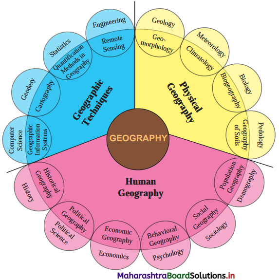
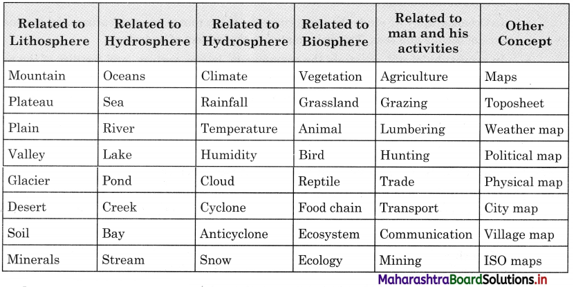
Choose the correct option by identifying the correct correlation in the sentences.

Question 1.
………………. is not included in the atmosphere.
(a) Weather
(b) Climate
(c) Precipitation
(d) River
Answer:
(d) River

Question 2.
……………….. is not included in the hydrosphere.
(a) Mountain
(b) Ocean
(c) Sea
(d) Lake
Answer:
(a) Mountain

Maharashtra Board Class 12 Geography Important Questions Chapter 8 Geography: Nature and Scope

Question 3.
……………….. is not included in lithosphere.
(a) Relief
(b) Drainage
(c) Weather
(d) Slope
Answer:
(c) Weather

Question 4.
…………………. is not included in Human Geography.
(a) GIS
(b) Social Geography
(c) Behavioural Geography
(d) Economic Geography
Answer:
(a) GIS

Question 5.
……………… is not included in Human Geography.
(a) Historical Geography
(b) Statistics
(c) Political Geography
(d) Population Geography
Answer:
(b) Statistics

Question 6.
…………………. is not included in geographical techniques.
(a) Statistics
(b) Cartography
(c) Remote sensing
(d) GIS
Answer:
(a) Statistics

Question 7.
………………… is not included in biosphere.
(a) Food chain
(b) Ecosystem
(c) Macro-organisms
(d) Lakes
Answer:
(d) Lakes

Maharashtra Board Class 12 Geography Important Questions Chapter 8 Geography: Nature and Scope

Identify the correct correlation.

A : Assertion, R : Reasoning
Question 1.
A – The Earth is dynamic in nature.
R – The geographical phenomena are not static but dynamic.
(a) Only A is correct.
(b) Only R is correct.
(c) Both A and R are correct and R is correct explanation of A.
(d) Both A and R are correct but R is not correct explanation A.
Answer:
(d) Both A and R are correct but R is not correct explanation A.

Question 2.
A – Geography is dynamic in nature.
R – Geography is a study of space and time.
(a) Only A is correct.
(b) Only R is correct.
(c) Both A and R are correct and R is correct explanation of A.
(d) Both A and R are correct but R is not correct explanation A.
Answer:
(c) Both A and R are correct and R is correct explanation of A.

Question 3.
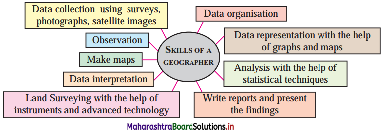
A – Skills of geographers have enriched the subject as newer branches of geography.
R – Skills acquired by geographers enable them to make observations and describe various elements on the earth.
(a) Only A is correct.
(b) Only R is correct.
(c) Both A and R are correct and R is correct explanation of A.
(d) Both A and R are correct but R is not correct explanation A.
Answer:
(c) Both A and R are correct and R is correct explanation of A.

Maharashtra Board Class 12 Geography Important Questions Chapter 8 Geography: Nature and Scope

Question 4.
A – Geography is an integrating and inter disciplinary discipline.
R – Many branches of geography have developed from mainstreams of disciplines.
(a) Only A is correct.
(b) Only R is correct.
(c) Both A and R are correct and R is correct explanation of A.
(d) Both A and R are correct but R is not correct explanation A.
Answer:
(c) Both A and R are correct and R is correct explanation of A.

Identify the incorrect factor.

Question 1.
The main branches of geography are
(a) Physical geography
(b) Economic geography
(c) Pedology
(d) Human geography
Answer:
(c) Pedology

Question 2.
The main branches of Physical geography are
(a) Geomorphology
(b) Climatology
(c) Biogeography
(d) Remote sensing
Answer:
(d) Remote sensing

Question 3.
The cartographic techniques include
(a) Geology
(b) GPS
(c) Cartography
(d) GIS
Answer:
(a) Geology

Maharashtra Board Class 12 Geography Important Questions Chapter 8 Geography: Nature and Scope

Question 4.
The subjects related to Human geography are
(a) History
(b) Social geography
(c) Political science
(d) Psychology
Answer:
(b) Social geography

Question 5.
The subjects related to Human geography are
(a) Demography
(b) Sociology
(c) Historical geography
(d) Economics
Answer:
(c) Historical geography

Question 6.
The branches of Human geography are
(a) Economics
(b) Population geography
(c) Behavioural geography
(d) Historical geography
Answer:
(a) Economics

Question 7.
The cartographic techniques include
(a) Computer science
(b) Cartography
(c) Quantification methods in geography
(d) GIS
Answer:
(a) Computer science

Question 8.
The branches of Human geography are
(a) Political geography
(b) Social geography
(c) Psychology
(d) Economic geography
Answer:
(c) Psychology

Maharashtra Board Class 12 Geography Important Questions Chapter 8 Geography: Nature and Scope

Question 9.
The subjects related to Physical geography are
(a) Biogeography
(b) Geology
(c) Meteorology
(d) Biology
Answer:
(a) Biogeography

Complete the Chain

Question 1.

ABC
(1) Physical Geography(1) Computer science(1) GIS
(2) Human Geography(2) Pedology(2) Geography of Soils
(3) Geomorphology(3) Psychology(3) Behavioural Geography

Answer:

ABC
(1) Physical Geography(1) Pedology(1) Geography of Soils
(2) Human Geography(2) Psychology(2) Behavioural Geography
(3) Geomorphology(3) Computer science(3) GIS

Maharashtra Board Class 12 Geography Important Questions Chapter 8 Geography: Nature and Scope

Question 2.

ABC
(1) Geographic Techniques(1) Geology(1) Population Geography
(2) Human Geography(2) Engineering(2) Geomorphology
(3) Physical Geography(3) Demography(3) Remote Sensing

Answer:

ABC
(1) Geographic Techniques(1) Engineering(1) Remote Sensing
(2) Human Geography(2) Demography(2) Population Geography
(3) Physical Geography(3) Geology(3) Geomorphology

Question 3.

ABC
(1) Human Geography(1) Meteorology(1) Political Geography
(2) Physical Geography(2) Geodesy(2) Cartography
(3) Geographic Techniques(3) Political Science(3) Climatology

Answer:

ABC
(1) Human Geography(1) Political Science(1) Political Geography
(2) Physical Geography(2) Meteorology(2) Climatology
(3) Geographic Techniques(3) Geodesy(3) Cartography

Maharashtra Board Class 12 Geography Important Questions Chapter 8 Geography: Nature and Scope

Give geographical reasons.

Question 1.
Geography offers vast scope for career.
Answer:

  • Due to the dynamic nature of geography, various advanced statistical techniques and computer programs are used to study and explain the geographical phenomenon.
  • Presently, because of global warming, natural disasters occur in various areas of the world. However, different techniques are being used to study the intensity of disasters or provide warnings before a disaster. Hence, disaster management is now a new field for my career.
  • Geographers have a wide scope to work as climate analysts, water conservation, water, and air pollution monitoring, environmental conservation, environmental education/awareness, etc., because of the increasing air and water pollution and environmental degradation.
  • Maps are essential in geography. Nowadays, maps are not made manually but with the help of GIS software. Thus, there is a wide scope for a career in cartography.
  • A population study of a country goes on continuously; therefore, many job opportunities as a surveyor, census officer, or data collector.
  • Research is also going on in various branches of geography; therefore, there are career opportunities as a researcher or research analyst.
  • There are also career opportunities in book writing, teaching, journalism, freelancing preparing maps and diagrams for textbooks, data scientist, tour guide, report writing, urban planner, travel blogger, data scientist, etc.
  • Thus, geography offers vast scope for a career.

Maharashtra Board Class 12 Geography Important Questions Chapter 7 Region and Regional Development

Balbharti Maharashtra State Board Class 12 Geography Important Questions Chapter 7 Region and Regional Development Important Questions and Answers.

Maharashtra State Board 12th Geography Important Questions Chapter 7 Region and Regional Development

Choose the correct option by identifying the correct correlation in the sentences.

Question 1.
Formal region …………….
(a) USA
(b) TV signal areas
(c) Wireless
(d) Wi-Fi hotspot
Answer:
(a) USA

Question 2.
Functional region …………….
(a) Rice producing area
(b) Desert area
(c) Iron and steel producing areas
(d) Wireless
Answer:
(d) Wireless

Maharashtra Board Class 12 Geography Important Questions Chapter 7 Region and Regional Development

Question 3.
In rural areas much of the land is used for …………….
(a) housing
(b) agriculture
(c) market
(d) transport
Answer:
(b) agriculture

Question 4.
Important indicator of development is …………….
(a) Per capita income
(b) Out migration
(c) Slow growth of population
(d) Dependency ratio
Answer:
(a) Per capita income

Question 5.
Functional region is …………….
(a) Canada
(b) Africa
(c) Europe
(d) Pune metropolitan region
Answer:
(d) Pune metropolitan region

Question 6.
Formal region …………….
(a) Mumbai Metropolitan region
(b) Delhi Metropolitan region
(c) West Bengal
(d) Nagpur Metropolitan region
Answer:
(c) West Bengal

Maharashtra Board Class 12 Geography Important Questions Chapter 7 Region and Regional Development

Identify the correct correlation.

A : Assertion, R : Reasoning
Question 1.
A – A functional region may be heterogeneous in nature.
R – It may involve more than one type of physical or political region.
(a) Only A is correct.
(b) Only R is correct.
(c) Both A and R are correct and R is correct explanation of A.
(d) Both A and R are correct but R is not correct explanation A.
Answer:
(c) Both A and R are correct and R is correct explanation of A.

Question 2.
A – Cities can be considered as a functional region.
R – Buses move people from the suburb to the city central area.
(a) Only A is correct.
(b) Only R is correct.
(c) Both A and R are correct and R is correct explanation of A.
(d) Both A and R are correct but R is not correct explanation A.
Answer:
(c) Both A and R are correct and R is correct explanation of A.

Question 3.
A – There are many indicators of development like quality and quantity of population, education, poverty, etc.
R – But only one indictor can decide the development of region.
(a) Only A is correct.
(b) Only R is correct.
(c) Both A and R are correct and R is correct explanation of A.
(d) Both A and R are correct but R is not correct explanation A.
Answer:
(a) Only A is correct.

Maharashtra Board Class 12 Geography Important Questions Chapter 7 Region and Regional Development

Question 4.
A – Population and development are closely interrelated.
R – Population influences development and in turn, is influenced by development.
(a) Only A is correct.
(b) Only R is correct.
(c) Both A and R are correct and R is correct explanation of A.
(d) Both A and R are correct but R is not correct explanation A.
Answer:
(c) Both A and R are correct and R is correct explanation of A.

Identify the incorrect factor.

Question 1.
In urban areas much of the land is used for
(a) Housing
(b) Commercial
(c) Mining
(d) Industries
Answer:
(c) Mining

Question 2.
Factors responsible for regional development
(a) Physical factors
(b) Economic factors
(c) Environment factors
(d) Push and pull factors
Answer:
(d) Push and pull factors

Question 3.
Factors responsible for imbalanced development
(a) Accessibility
(b) Altitude
(c) Migration
(d) Relief
Answer:
(c) Migration

Maharashtra Board Class 12 Geography Important Questions Chapter 7 Region and Regional Development

Question 4.
A region may not be well developed if
(a) Landlocked
(c) Lack of natural harbour
(b) High mountain ranges
(d) Favourable climate
Answer:
(d) Favourable climate

Question 5.
Functional region
(a) Wi-Fi hotspots
(b) TV signal area
(c) Assam
(d) Wireless
Answer:
(c) Assam

Question 6.
Formal regions
(a) West Bengal
(b) Rice producing area
(c) A city
(d) Africa
Answer:
(c) A city

Complete the Chain

Question 1.

ABC
(1) Amazon(1) River(1) Physical
(2) Khandesh(2) Administrative(2) Political
(3) Bengali speaking(3) Language(3) Linguistics

Answer:

ABC
(1) Amazon(1) Language(1) Linguistics
(2) Khandesh(2) River(2) Physical
(3) Bengali speaking(3) Administrative(3) Political

Maharashtra Board Class 12 Geography Important Questions Chapter 7 Region and Regional Development

Question 2.

ABC
(1) Ganga Basin(1) Island(1) Tourism
(2) Japan(2) Beautiful scenery(2) Agriculture and industries
(3) Indonesia(3) Fertile soil(3) Trade and import resources

Answer:

ABC
(1) Ganga Basin(1) Fertile soil(1) Agriculture and industries
(2) Japan(2) Island(2) Trade and import resources
(3) Indonesia(3) Beautiful scenery(3) Tourism

Question 3.

ABC
(1) Later stage of Demographic Transition Theory(1) Higher population(1) Higher amount of capital resources consumed
(2) Population pyramid(2) Pull factor(2) Lower per capita income
(3) Migration(3) Low growth of population(3) Greater development less spent on population
(4) Indicator of economic development(4) High dependency ratio(4) Good employment opportunities

Answer:

ABC
(1) Later stage of Demographic Transition Theory(1) Low growth of population(1) Greater development less spent on population
(2) Population pyramid(2) High dependency ratio(2) Higher amount of capital resources consumed
(3) Migration(3) Pull factor(3) Good employment opportunities
(4) Indicator of economic development(4) Higher population(4) Lower per capita income

Maharashtra Board Class 12 Geography Important Questions Chapter 7 Region and Regional Development

Give geographical reasons.

Question 1.
Population and development are closely interrelated.
Answer:

  • The economic development in any country/region depends upon the quantity and quality of its people.
  • Higher the numbers of people lower the per capita income, which indicates low development in the country/region.
  • Lesser number of people in the country/region lead to shortage of skilled labour and limited development. Higher number of populations is good for the development of the country/region.
  • The quality of people includes age structure, sex ratio, occupational structure, literacy rate, etc. If these aspects of the population are favourable, then there is development in the country/ region.
  • Age group of people in the country also affects the development. If there are more people in the working age group then there is more economic development.
  • Migration also affects the economic development of the region/country. If people migrate to any region it indicates employment opportunities and economic development.
  • However, too much migration may create pressure of population on available resources and labour thus, adversely affecting the development of the country/region.

Maharashtra Board Class 12 Geography Important Questions Chapter 7 Region and Regional Development

Write short notes on.

Question 1.
Causes of regional imbalances in India.
Answer:
India faces imbalanced regional development due to uncertainty in the development of states or districts.

The main factors affecting regional development of any region are physical factors like climate, soil, location, relief, geology of the country, forest, etc.

Some regions have favourable relief, climate, fertile soil or favourable geographical location or ample natural resources. Such regions develop faster. For example, the northern plains of India are well developed due to plain relief, fertile soil and moderate climate. Coastal cities like Mumbai, Chennai is well developed due to the development of ports and harbours.

Some regions have unfavourable relief or climate. Therefore, development is limited. For example, the north-eastern states of India have less development due to hilly relief, heavy rainfall, frequent flooding, and inaccessibility.

Human factors like market demand, transportation, power supply, banking and insurance facilities, communication facilities, technological development, skilled labour, etc., contribute to the development of a region. For example, due to unfavourable human factors, the Himalayan region is less developed.

Thus, there is a regional imbalance in India.

Maharashtra Board Class 12 Geography Important Questions Chapter 6 Tertiary Economic Activities

Balbharti Maharashtra State Board Class 12 Geography Important Questions Chapter 6 Tertiary Economic Activities Important Questions and Answers.

Maharashtra State Board 12th Geography Important Questions Chapter 6 Tertiary Economic Activities

Choose the correct option.

Question 1.
Canadian Pacific Railway connects
(a) Halifax – New York
(b) Vancouver – Boston
(c) Halifax- New Orleans
(d) Vancouver – Halifax
Answer:
(d) Vancouver – Halifax

Maharashtra Board Class 12 Geography Important Questions Chapter 6 Tertiary Economic Activities

Question 2.
Panama Canal connects
(a) Atlantic – Pacific
(b) Atlantic – Indian Ocean
(c) Bay of Bengal – Arabian sea
(d) Mediterranean Sea – Red sea
Answer:
(a) Atlantic – Pacific

Question 3.
Trans-Siberian Railway line connects
(a) Moscow – Novosibirsk
(b) Vancouver – Boston
(c) Moscow – Khabarovsk
(d) Moscow – Vladivostok
Answer:
(d) Moscow – Vladivostok

Question 4.
Suez Canal connects
(a) Atlantic – Pacific
(b) Atlantic – Indian Ocean
(c) Bay of Bengal – Arabian sea
(d) Mediterranean Sea – Red sea
Answer:
(d) Mediterranean Sea – Red sea

Identify the correct correlation.

A : Assertion, R : Reasoning
Question 1.
A – Some products are processed in secondary activities.
R – Some products received from primary activities cannot be consumed directly.
(a) Only A is correct.
(b) Only R is correct.
(c) Both A and R are correct and R is correct explanation of A.
(d) Both A and R are correct but R is not the correct explanation of A.
Answer:
(c) Both A and R are correct and R is correct explanation of A.

Maharashtra Board Class 12 Geography Important Questions Chapter 6 Tertiary Economic Activities

Question 2.
A – In international trade of grapes, air transport is used.
R – Grapes are perishable goods.
(a) Only A is correct.
(b) Only R is correct.
(c) Both A and R are correct and R is correct explanation of A.
(d) Both A and R are correct but R is not the correct explanation of A.
Answer:
(c) Both A and R are correct and R is correct explanation of A.

Question 3.
A – In Africa and South America, construction of roads and railways of long distance is difficult.
R – Generally, it is easier to build roads and railways where relief is not rugged.
(a) Only A is correct.
(b) Only R is correct.
(c) Both A and R are correct and R is correct explanation of A.
(d) Both A and R are correct but R is not the correct explanation of A.
Answer:
(d) Both A and R are correct but R is not the correct explanation of A.

Question 4.
A – Densely populated countries have to worry about feeding their own populations.
R – The country with less population will depend less on trade because of less human resources engaged in production.
(a) Only A is correct.
(d) Only R is correct.
(c) Both A and R are correct and R is correct explanation of A.
(d) Both A and R are correct but R is not the correct explanation of A.
Answer:
(d) Both A and R are correct but R is not the correct explanation of A.

Maharashtra Board Class 12 Geography Important Questions Chapter 6 Tertiary Economic Activities

Identify the incorrect factor.

Question 1.
Important stations of Trans-Siberian railway
(a) Vladivostok
(b) Moscow
(c) Hamburg
(d) Novosibirsk
Answer:
(c) Hamburg

Question 2.
Important stations on Canadian Pacific railway
(a) Halifax
(b) Boston
(c) Montreal
(d) Vancouver
Answer:
(b) Boston

Question 3.
Important ports on Mumbai-Tokyo waterway
(a) Mumbai
(b) Colombo
(c) Perth
(d) Tokyo
Answer:
(c) Perth

Maharashtra Board Class 12 Geography Important Questions Chapter 6 Tertiary Economic Activities

Question 4.
Important airports on Mumbai-Washington air route
(a) Istanbul
(b) London
(c) Halifax
(d) Washington
Answer:
(c) Halifax

Question 5.
Parts of the world known for their specific art and craft
(a) Kashmiri shawl
(b) Indian textile
(c) Iranian carpets
(d) Batik print of Indonesia
Answer:
(b) Indian textile

Question 6.
Transportation facilities are well developed in
(a) North America
(b) Africa
(c) Asia
(d) Europe
Answer:
(b) Africa

Question 7.
Important quinary activities are-
(a) Government officials
(b) Scientists
(c) Judges
(d) Statisticians
Answer:
(d) Statisticians

Maharashtra Board Class 12 Geography Important Questions Chapter 6 Tertiary Economic Activities

Question 8.
Important quaternary activities are-
(a) Financial planner
(b) Tax consultant
(c) Judges
(d) Software developers
Answer:
(c) Judges

Question 9.
The factors which affect tertiary activities are-
(a) Soil
(b) Climate
(c) Relief
(d) Location
Answer:
(a) Soil

Complete the Chain

Question 1.

ABC
(1) Climate(1) Soil(1) Import food
(2) Natural Resources(2) High density(2) Woollen products
(3) Population(3) Dry farming(3) Agriculture
(4) Culture(4) Snow covered area(4) Kashmiri shawl
(5) Israel(5) Art and craft(5) Export services for agriculture

Answer:

ABC
(1) Climate(1) Snow covered area(1) Woollen products
(2) Natural Resources(2) Soil(2) Agriculture
(3) Population(3) High density(3) Import food
(4) Culture(4) Art and craft(4) Kashmiri shawl
(5) Israel(5) Dry farming(5) Export services for agriculture

Maharashtra Board Class 12 Geography Important Questions Chapter 6 Tertiary Economic Activities

Question 2.

ABC
(1) Climate(1) Skills(1) Information technology
(2) Population(2) Tropical(2) Tea, Coffee export
(3) Culture(3) Poor soil(3) Export oil
(4) Gulf countries(4) Art and craft(4) Chinese porcelain

Answer:

ABC
(1) Climate(1) Tropical(1) Tea, Coffee export
(2) Population(2) Skills(2) Information technology
(3) Culture(3) Art and craft(3) Chinese porcelain
(4) Gulf countries(4) Poor soil(4) Export oil

Give geographical reasons.

Question 1.
The population of the country also affects trade.
Answer:
The quality and quantity of population in the country have direct effect on the trade.
Densely populated countries have a lot of local demand. So, there is hardly any surplus for export trade.
The thinly populated countries have limited local demand. Therefore, they have a lot of surplus for trade.

The quality of population also affects trade. More resourceful, enthusiastic and skilled people in the country, more innovative production and trade in the country.

In many countries, skills of a person is preserved from generation to generation. Hence, they are specialised in certain products. Therefore, they develop trade of such goods. For example, carpets in Iran, woollen goods of Jammu and Kashmir, Chinese porcelain, etc.

The standard of living also affects trade. In some countries population is less but due to high standard of living, there is more demand for expensive goods. So, import trade is developed there.

Maharashtra Board Class 12 Geography Important Questions Chapter 6 Tertiary Economic Activities

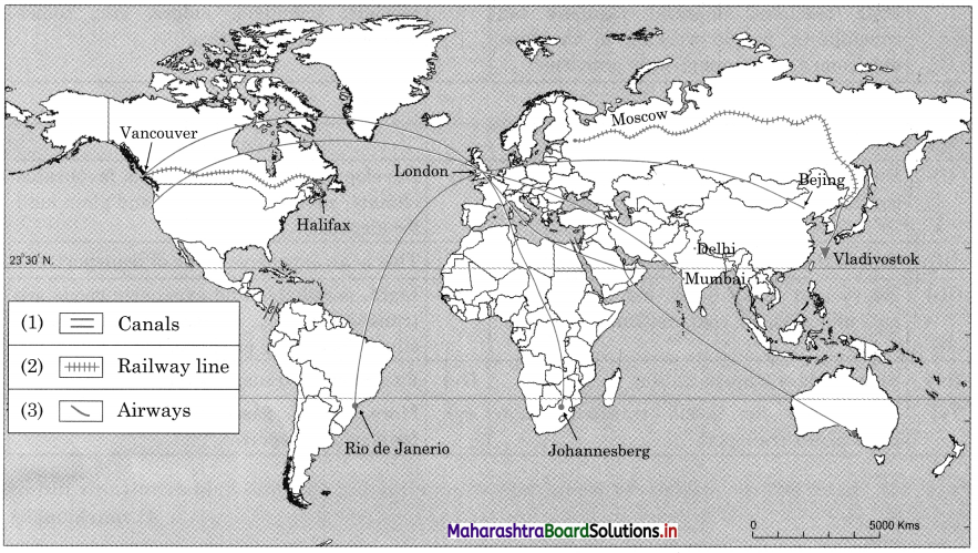
Answer the following questions by any given map.

Maharashtra Board Class 12 Geography Important Questions Chapter 6 Tertiary Economic Activities 1

  1. Write the name of transcontinental railway line in Russia.
  2. Write the name of transcontinental railway line in Canada.
  3. Write the name of canal which connects Red Sea with Mediterranean Sea or Asia with Europe.
  4. Write the name of canal which connects Pacific Ocean with Atlantic Ocean.
  5. Write the name of the important international airport of North India.
  6. Name the international airport of UK.
  7. Which means of transport are shown in the map?

Answer:

  1. The transcontinental railway line in Russia is the Trans-Siberian railway line.
  2. The transcontinental railway line in Canada is the Canadian-Pacific railway line.
  3. The canal which connects Red Sea with Mediterranean Sea or Asia with Europe is the Suez canal.
  4. The canal which connects Pacific Ocean with Atlantic Ocean is the Panama canal.
  5. The important international airport of North India is in Delhi.
  6. The important international airport of the UK is in London.
  7. The means of transport shown in the map are transcontinental railway lines and airways.

Maharashtra Board Class 12 Geography Important Questions Chapter 6 Tertiary Economic Activities

Write short notes on.

Question 1.
Climate and trade.
Answer:
Climate has a direct effect on agriculture of the country. Due to favourable climate there is specialisation of certain crops in some areas. For example, due to hot and humid climate there is specialisation of rice crops in Southeast Asian countries. So, they have developed trade of rice in the world.

The quality of grass depends upon climate. In cool climates, soft and juicy grass grows, so such area has developed pastoral activities and trade of animal products. For example, Australia and New Zealand have become one of the leading exporters of butter, cheese, condensed milk powder, mutton etc.

Climate also affects growth and type of forest in the country. Due to a cool climate in Canada, Russia, Scandinavian countries, coniferous forest grows which provide softwood; it has great demand in the world market. Therefore, Canada, Norway, Sweden, Finland, Russia are leading exporters of wood.

In some countries, there is specialisation of certain goods due to specific climate. For example, in snow covered areas there is more production of woollen goods; therefore, there is more export trade of woollen goods from Jammu and Kashmir states of India.

Maharashtra Board Class 12 Geography Important Questions Chapter 5 Secondary Economic Activities

Balbharti Maharashtra State Board Class 12 Geography Important Questions Chapter 5 Secondary Economic Activities Important Questions and Answers.

Maharashtra State Board 12th Geography Important Questions Chapter 5 Secondary Economic Activities

Choose the correct option by identifying the correct correlation in the sentences.

Question 1.
Secondary activities include
(a) Processing
(b) Commercial farming
(c) Horticulture
(d) Mining
Answer:
(a) Processing

Maharashtra Board Class 12 Geography Important Questions Chapter 5 Secondary Economic Activities

Question 2.
Economic factor deciding location of industry
(a) Labour
(b) Transport
(c) Market
(d) Agglomeration
Answer:
(c) Market

Question 3.
Industry in which semi-skilled labour is essential
(a) Food processing
(b) Electronic
(c) Construction
(d) Chemical
Answer:
(c) Construction

Question 4.
Industry having split location
(a) Food processing
(b) Automobile
(c) Iron and steel
(d) Jute textile
Answer:
(b) Automobile

Maharashtra Board Class 12 Geography Important Questions Chapter 5 Secondary Economic Activities

Question 5.
In India, which of the following industries have portal location?
(a) Iron and steel
(b) Oil refineries
(c) Food processing
(d) Dairy
Answer:
(b) Oil refineries

Identify the correct correlation.

Question 1.
A – Cottage industry is the most basic industry.
R – Some of the products of this industry have great demand abroad.
(a) Only A is correct.
(b) Only R is correct.
(c) Both A and R are correct and R is correct explanation of A.
(d) Both A and R are correct but R is not the correct explanation of A.
Answer:
(d) Both A and R are correct but R is not the correct explanation of A.

Question 2.
A – Public sector industries are owned by the state.
R – Marketing of goods is through private agencies.
(a) Only A is correct.
(b) Only R is correct.
(c) Both A and R are correct and R is correct explanation of A.
(d) Both A and R are correct but R is not the correct explanation of A.
Answer:
(a) Only A is correct.

Question 3.
A – Tata Iron and Steel Industry is the basic industry.
R – Finished product of this industry is the raw material in many industries.
(a) Only A is correct.
(b) Only R is correct.
(c) Both A and R are correct and R is correct explanation of A.
(d) Both A and R are correct but R is not the correct explanation of A.
Answer:
(c) Both A and R are correct and R is correct explanation of A.

Maharashtra Board Class 12 Geography Important Questions Chapter 5 Secondary Economic Activities

Identify the incorrect factor.

Question 1.
Physical factors of location of industries,
(a) Climate
(b) Market
(c) Water
(d) Physiography
Answer:
(b) Market

Question 2.
Physical factors of location of industries,
(a) Transport
(b) Labour
(c) Land
(d) Capital
Answer:
(d) Capital

Question 3.
Physical factors of location of industries,
(a) Land
(b) Labour
(c) SEZs
(d) Water
Answer:
(c) SEZs

Question 4.
Industrial regions in the United States of America.
(a) New England
(b) England
(c) New York
(d) Mid-Atlantic
Answer:
(b) England

Maharashtra Board Class 12 Geography Important Questions Chapter 5 Secondary Economic Activities

Question 5.
Industrial regions in Japan.
(a) Tokyo
(b) Kobe
(c) Kimberly
(d) Kawasaki
Answer:
(c) Kimberly

Question 6.
Industrial regions in Africa.
(a) Congo
(b) Ghana
(c) Angela
(d) Zambia
Answer:
(c) Angela

Question 7.
Important industries in New Zealand.
(a) Meat products
(b) Dairy products
(c) Canned fruits
(d) Oil refining
Answer:
(d) Oil refining

Question 8.
Agro-based industries
(a) Cotton textile
(b) Sugar
(c) Food processing
(d) Steel industry
Answer:
(d) Steel industry

Maharashtra Board Class 12 Geography Important Questions Chapter 5 Secondary Economic Activities

Question 9.
Proposed economic corridors
(a) DMIC
(b) ADKIC
(c) BMC
(d) BMIC
Answer:
(c) BMC

Complete the Chain

Question 1.

ABC
(1) Co-operative sector(1) Owned by private individual(1) ONGC
(2) MNCs(2) Only one state(2) AMUL
(3) Private sector(3) More than one country(3) BHEL
(4) Public sector(4) Group of people set up(4) TISCO

Answer:

ABC
(1) Co-operative sector(1) Group of people set up(1) AMUL
(2) MNCs(2) More than one country(2) ONGC
(3) Private sector(3) Owned by private individual(3) TISCO
(4) Public sector(4) Only one state(4) BHEL

Maharashtra Board Class 12 Geography Important Questions Chapter 5 Secondary Economic Activities

Question 2.

ABC
(1) Household industry(1) Material produced by industry used as raw material by other industries(1) Iron and Steel industry
(2) Heavy industry(2) Goods produced for direct consumption(2) Electronic industry
(3) Light industry(3) Manufacture parts and components(3) Iron sheets
(4) Ancillary industry(4) Use local raw material(4) Potters

Answer:

ABC
(1) Household industry(1) Use local raw material(1) Potters
(2) Heavy industry(2) Material produced by industry used as raw material by other industries(2) Iron and Steel industry
(3) Light industry(3) Goods produced for direct consumption(3) Electronic industry
(4) Ancillary industry(4) Manufacture parts and components(4) Iron sheets

Maharashtra Board Class 12 Geography Important Questions Chapter 5 Secondary Economic Activities

Complete the following as per instructions.

Question 1.
Arrange the industrial regions of USA from North to South.
New York, Mid-Atlantic, New England, Eastern Texas.
Answer:
New England, New York, Mid-Atlantic, Eastern Texas.

Question 2.
Arrange the industrial regions of Australia from East to West.
Adelaide, Melbourne, Sydney, Perth
Answer:
Sydney, Melbourne, Adelaide, Perth.

Question 3.
Arrange the industrial regions of Japan from North to South. Tokyo, Osaka, Yokohama, Nagoya.
Answer:
Tokyo, Yokohama, Nagoya, Osaka.

Maharashtra Board Class 12 Geography Important Questions Chapter 5 Secondary Economic Activities

Give geographical reasons.

Question 1.
What factors are responsible for non-development of industries in Central Australia?
Answer:

  • Central part of Australia is covered by the Great Australian desert.
  • Since it is a desert, physical factors like climate, water, raw materials, labour and transport facilities are not suitable for the development of industries.
  • Because of these adverse physical conditions, the density of population is extremely low and therefore there are limited markets. Also, due to these unfavourable economic factors also industries are not developed in central Australia.

Differentiate between.

Question 1.
Public Sector Industries and Private Sector Industries.
Answer:

Public Sector IndustriesPrivate Sector Industries
(i) Public sector industries are owned by the state.(i) Private sector industries are owned by a private individual or in partnership.
(ii) Government investment and marketing of goods.(ii) Individuals or partners make investment and profit or loss is shared equally.
(iii) Bharat Heavy Electrical Limited (BHEL) is a public sector industry.(iii) Tata Iron and Steel Company (TISCO) is a private sector industry.

Maharashtra Board Class 12 Geography Important Questions Chapter 5 Secondary Economic Activities

Question 2.
Large scale industries and Cottage or Household industries
Answer:

Large scale industriesCottage or Household industries
(i) These industries require huge amount of capital for machinery and infrastructure.(i) These industries need limited capital, since machinery and infrastructure.
(ii) Goods are produced to sell in the regional or national market.(ii) Goods are produced for the sale in the local market.
(iii) For example, cotton textile industry or iron and steel industry.(iii) For example, weavers, blacksmith, sculpture, carpenter etc.
(iv) These industries require skilled labour since all products are handmade.(iv) These industries require machinery than skilled labour.

Maharashtra Board Class 12 Geography Important Questions Chapter 5 Secondary Economic Activities

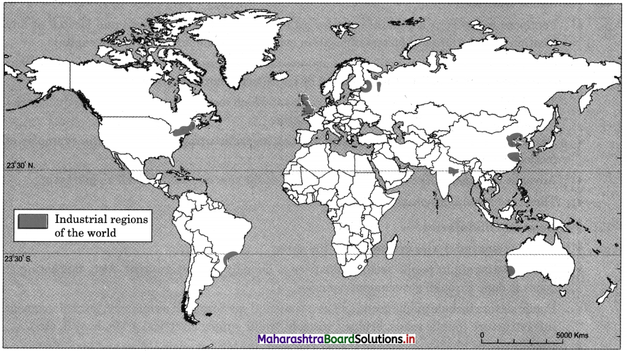
Answer the following Questions by using given map.

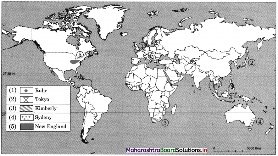
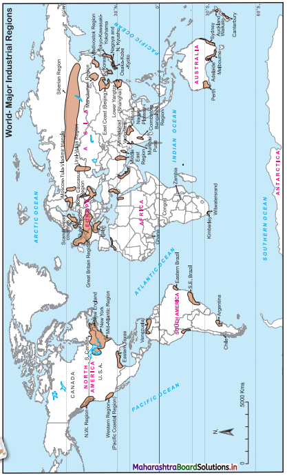
Maharashtra Board Class 12 Geography Important Questions Chapter 5 Secondary Economic Activities 1

  1. Name the industrial region of India.
  2. Name the industrial region of north China.
  3. Name the industrial region of Russia
  4. Name the industrial region on North-East part of USA.
  5. Name the industrial region on South-Western coast of Australia.
  6. Name the industrial region of South Japan.
  7. Name the industrial region of South America.
  8. Name the industrial region of South China.
  9. Name the industrial region of Europe.

Answer:

  1. The industrial region of India is Chota Nagpur region.
  2. The industrial region of North China is East coast industrial region (Beijing).
  3. The industrial region of Russia is Moscow-Tula region.
  4. The industrial region of North-East part of USA is New England industrial region.
  5. The industrial region on South-Western coast of Australia is Perth industrial region.
  6. The industrial region of South Japan is Osaka-Kobe-Kyoto industrial region.
  7. The industrial region of South America is South-East Brazil industrial region.
  8. The industrial region of South China is Lower Yangtze industrial region.
  9. The industrial region of Europe is Great Britain industrial region.

Maharashtra Board Class 12 Geography Important Questions Chapter 5 Secondary Economic Activities

Write short notes on.

Question 1.
Classification of industries based on the source of raw material.
Answer:
Based on the source of raw material, industries are classified as follows:
Agro-based industries : The industries which use agricultural produce as raw material and process them into finished products are called agro-based industries. For example, fruit processing industries which produce jam, jelly, sherbet, fruit canning, etc., locate near fruit growing areas.

Mineral-based industries : These industries use minerals as raw material and after processing produce finished products. For example, petrochemical industries use mineral oil as raw material and produce petrol, diesel, lubricants, kerosene, paraffin wax etc.

Forest-based industries : These industries use forest products such as wood, tendu leaves, rubber, turpentine, grass, etc., as raw material and after processing produce finished products. For example, paper industries use wood and make paper, rubber industries use natural rubber to make rubber products, scented oil is made from various grass varieties.

Marine-based industries : These industries use marine resource as raw material and after processing produce finished products. For example, fish canning, fish oil making industries use fish as raw material. Other marine-based industries are industries producing decorative articles/ purses, by using sea shells as raw material or decorative articles of corals.

Pastoral-based industries: These industries use animal product such as milk, meat or body parts of animals such as bones, horns, wool, skin etc. For example, dairy industries use milk, woollen textile mills use wool, or leather industries use skin of animals as raw material.

Maharashtra Board Class 12 Geography Important Questions Chapter 4 Primary Economic Activities

Balbharti Maharashtra State Board Class 12 Geography Important Questions Chapter 4 Primary Economic Activities Important Questions and Answers.

Maharashtra State Board 12th Geography Important Questions Chapter 4 Primary Economic Activities

Identify the correct correlation.

A: Assertion R : Reasoning
Question 1.
A – Collection of forest products is not done on large scale in the equatorial forest region.
R – Humid and unhealthy climate of the equatorial region.
(a) Only A is correct.
(b) Only R is correct.
(c) Both A and R are correct and R is the correct explanation of A.
(d) Both A and R are correct but R is not the correct explanation of A.
Answer:
(c) Both A and R are correct and R is the correct explanation of A.

Maharashtra Board Class 12 Geography Important Questions Chapter 4 Primary Economic Activities

Question 2.
A – Commercial lumbering is not done in equatorial rainforest.
R – Trees in equatorial rain forest have hardwood.
(a) Only A is correct.
(b) Only R is correct.
(c) Both A and R are correct and R is the correct explanation of A.
(d) Both A and R are correct but R is not the correct explanation of A.
Answer:
(c) Both A and R are correct and R is the correct explanation of A.

Question 3.
A – Lumbering is mostly practiced in coniferous forest region.
R – Coniferous forest are not very dense.
(a) Only A is correct.
(b) Only R is correct.
(c) Both A and R are correct and R is the correct explanation of A.
(d) Both A and R are correct but R is not the correct explanation of A.
Answer:
(a) Only A is correct.

Question 4.
A – Fishing on the coastal areas of Japan is well developed.
R – Presence of cold and warm ocean water currents.
(a) Only A is correct.
(b) Only R is correct.
(c) Both A and R are correct and R is the correct explanation of A.
(d) Both A and R are correct but R is not the correct explanation of A.
Answer:
(c) Both A and R are correct and R is the correct explanation of A.

Maharashtra Board Class 12 Geography Important Questions Chapter 4 Primary Economic Activities

Question 5.
A – Animal husbandry has developed on a commercial basis in North America and Australia.
R – In North and South America animal husbandry is carried out with the help of advanced technology on a commercial basis.
(a) Only A is correct.
(b) Only R is correct.
(c) Both A and R are correct and R is the correct explanation of A.
(d) Both A and R are correct but R is not the correct explanation of A.
Answer:
(c) Both A and R are correct and R is the correct explanation of A.

Identify the incorrect factor

Question 1.
Commercial fishing is carried along the following coastlines.
(a) North-East Atlantic coastline
(b) North-West Atlantic coastline
(c) Eastern coastline of Africa
(d) North-West coastline of Pacific Ocean
Answer:
(c) Eastern coastline of Africa

Maharashtra Board Class 12 Geography Important Questions Chapter 4 Primary Economic Activities

Question 2.
Agriculture is developed in the following continents.
(a) Antarctica
(b) Asia
(c) Europe
(d) North America
Answer:
(a) Antarctica

Question 3.
Animal husbandry is developed on a commercial basis in the following continents.
(a) North America
(b) Australia
(c) Asia
(d) South America
Answer:
(c) Asia

Question 4.
The following physical factors are important for agriculture.
(a) Climate
(b) Transport
(c) Soil
(d) Relief
Answer:
(b) Transport

Maharashtra Board Class 12 Geography Important Questions Chapter 4 Primary Economic Activities

Question 5.
The following economic factors are essential for agriculture.
(a) Transport
(b) Storage facilities
(c) Climate
(d) Capital
Answer:
(c) Climate

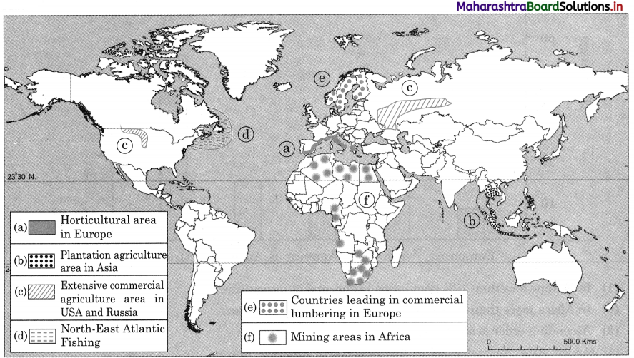
On an outline map of the world, show the following with appropriate symbols and prepare-an index.

Question 1.
(a) Horticultural area in Europe
(b) Plantation agriculture area in Asia
(c) Extensive commercial agriculture area in USA and Russia
(d) North-East Atlantic fishing
(e) Countries leading in commercial lumbering in Europe,
(f) Mining areas in Africa
Answer:
Maharashtra Board Class 12 Geography Important Questions Chapter 4 Primary Economic Activities 1

Maharashtra Board Class 12 Geography Important Questions Chapter 3 Human Settlements and Land Use

Balbharti Maharashtra State Board Class 12 Geography Important Questions Chapter 3 Human Settlements and Land Use Important Questions and Answers.

Maharashtra State Board 12th Geography Important Questions Chapter 3 Human Settlements and Land Use

Choose the correct option by identifying the correct correlation in the sentences.

Question 1.
In dry region is crucial for the development of settlements.
(a) climate
(b) water
(c) soil
(d) drainage
Answer:
(b) water

Question 2.
Sometimes factor is responsible to the fragmentation of settlement.
(a) social
(b) physical
(c) political
(d) religion
Answer:
(a) social

Question 3.
………………… settlement develops along a road.
(a) Rectangular
(b) Linear
(c) Radial
(d) Circular
Answer:
(b) Linear

Maharashtra Board Class 12 Geography Important Questions Chapter 3 Human Settlements and Land Use

Question 4.
……………… settlement is found at the confluence point of the river.
(a) Triangular
(b) Radial
(c) Linear
(d) Rectangular
Answer:
(a) Triangular

Question 5.
………………. settlement grows around a central object.
(a) Circular
(b) Radial
(c) Linear
(d) Rectangular
Answer:
(b) Radial

Question 6.
With the development of settlement and increase in size of population ………………. pattern develops.
(a) radial
(b) rectangular
(c) circular
(d) patternless
Answer:
(d) patternless

Identify the correct correlation.

Question 1.
A – Houses are built along the source of water.
R – In dry regions water is a crucial factor.
(a) Only A is correct.
(b) Only R is correct.
(c) Both A and R are correct and R is the correct explanation of A.
(d) Both A and R are correct but R is not the correct explanation of A.
Answer:
(d) Both A and R are correct but R is not the correct explanation of A.

Question 2.
A – Land cover can be determined by analysing the satellite imagery.
R – Land use cannot be determined from satellite imagery alone.
(a) Only A is correct.
(b) Only R is correct.
(c) Both A and R are correct and R is the correct explanation of A.
(d) Both A and R are correct but R is not the correct explanation of A.
Answer:
(d) Both A and R are correct but R is not the correct explanation of A.

Identify the incorrect factor.

Question 1.
Cantonment towns in India.
(a) Khadki
(b) Agra
(c) Dehu road
(d) Kolhapur
Answer:
(d) Kolhapur

Maharashtra Board Class 12 Geography Important Questions Chapter 3 Human Settlements and Land Use

Question 2.
Religious towns in India.
(a) Kolhapur
(b) Varanasi
(c) Nashik
(d) Pune
Answer:
(d) Pune

Question 3.
Mining towns in India.
(a) Chandrapur
(b) Singrauli
(c) Hutar
(d) Belgaum
Answer:
(d) Belgaum

Question 4.
Suburbs of Mumbai.
(a) Sion
(b) Dombivali
(c) Kalyan
(d) Virar
Answer:
(a) Sion

Question 5.
On the basis of spacing between the house’s settlement are divided.
(a) Compact
(b) fragmented
(c) dispersal
(d) linear
Answer:
(d) linear

Question 6.
Tourism towns in India.
(a) Shimla
(b) Udaipur
(c) Manali
(d) Mumbai
Answer:
(d) Mumbai

Question 7.
Industrial towns in India.
(a) Jamshedpur
(b) Chinchwad
(c) Khopoli
(d) Mahabaleshwar
Answer:
(d) Mahabaleshwar

Complete the Chain

Question 1.

ABC
(1) Linear pattern(1) Around central object(1) Houses are closely spaced
(2) Triangular pattern(2) Along the road(2) Straight line
(3) Circular pattern(3) Around lake(3) Three sides growth
(4) Radial pattern(4) Confluence of river(4) Around centre

Answer:

ABC
(1) Linear pattern(1) Along the road(1) Straight line
(2) Triangular pattern(2) Confluence of river(2) Three sides growth
(3) Circular pattern(3) Around lake(3) Houses are closely spaced
(4) Radial pattern(4) Around central object(4) Around the centre

Maharashtra Board Class 12 Geography Important Questions Chapter 3 Human Settlements and Land Use

Question 2.

ABC
(1) Permanent pasture(1) Land left fallow for more than 5 years(1) Privately owned
(2) Area under miscellaneous tree crops(2) Owned by village Panchayat(2) It can be brought under cultivation
(3) Current fallow(3) Orchards and fruit trees(3) Common property resource
(4) Culturable waste-land(4) Land left without cultivation for one or less than one agricultural year(4) Cultural practice adopted for giving the land rest

Answer:

ABC
(1) Permanent pasture(1) Owned by village Panchayat(1) Common property resource
(2) Area under miscellaneous tree crops(2) Orchards and fruit trees(2) Privately owned
(3) Current fallow(3) Land left without cultivation for one or less than one agricultural year(3) Cultural practice adopted for giving the land rest
(4) Culturable waste-land(4) Land left fallow for more than 5 years(4) It can be brought under cultivation

Maharashtra Board Class 12 Geography Important Questions Chapter 3 Human Settlements and Land Use

Write short notes on.

Question 1.
Size and types of settlements.
Answer:

  • Settlements vary in size and type. The size of settlement varies from hamlet to metropolitan town.
  • A small settlement could be sparsely spaced and large size settlement could be closely spaced.
  • On the basis of spacing between the houses, settlements can be divided into four types such as compact/clustered/nucleated /dispersed settlements, semi clustered or fragmented settlements and isolated settlements etc.
  • Economic character and social structure of settlement varies with the size of settlement.
  • Settlements can also be divided into two types on the basis of their function namely rural settlements and urban settlements.
  • Due to large population in urban areas, urban settlements are compact and larger in size.
  • Rural settlements are semi-clustered or fragmented and smaller in size.
  • In urban settlements there are various functions such as industrial, commercial, administrative, educational, religious, cantonment, tourism etc., therefore urban settlements are multifunctional.
  • Some cities are known by their functional importance. For example, Allahabad is known as a religious centre, Jaipur is known as a tourist centre.
  • Secondary and tertiary activities are more developed in urban settlements. ,
  • In rural settlements primary activities are more developed compared to secondary and tertiary activities.
  • In rural settlements agriculture is the main function and other activities related to agriculture such as livestock rearing, tree crops growing, lumbering, fishing are developed.

Differentiate between.

Question 1.
Linear Settlement and Triangular Settlement
Answer:

Linear SettlementTriangular Settlement
(i) Settlements which develop along Roads, railway lines, canals or rivers.(i) Settlements which develop at the meeting point of two rivers or roads.
(ii) They grow in straight line or take shape of the road or river.(ii) They grow in all three sides depending upon physical or social reasons.
(iii) For example, settlement along Mumbai- Pune Highway.(iii) Settlement of Karad town along the meeting point of Krishna and Koyna river.

Maharashtra Board Class 12 Geography Important Questions Chapter 3 Human Settlements and Land Use

Answer the following questions in detail.

Question 1.
Explain the land use in rural areas.
Answer:
1. In rural areas land use is mainly for agriculture and related activities. The Land Records Department has done classification of land use in rural areas as follows:
Net sown area: The land which is used to grow various crops is net sown area. This is main land used in rural areas for agriculture.

Area under tree crops and groves : This land is used to grow fruit crops and orchards.

Area under permanent pastures : This land is covered with grass permanently and it is used for grazing.

2. This land is mostly owned by government or village panchayat.
Current fallow : This is a cultivable land but it is kept empty that is without cultivation for twelve months or less than that.

3. Due to continuous cropping on same patch of land, the land loses its fertility, therefore to regain the fertility of the soil, rest is given to land. During this period land regains the fertility naturally.

Fallow other than current fallow : This land is kept fallow for more than one year but less than five years to regain fertility naturally. Land becomes culturable wasteland, if it is kept fallow for more than five years.

Culturable wasteland : If land is kept fallow for more than five years, it is called culturable wasteland. This land can be used again for cultivation after reclamation practices.

Barren land or wasteland : The land which is not useful for cultivation is called barren land and therefore it is wasteland. For example, hilly area, desert land, marshy land, ravines etc.

Non-agricultural land : The land used for residential purpose, for construction of canals, dams, roads, agro-based industries, fruit processing industries etc., comes under this category. Land under forest: In rural areas some lands are under forest.

Maharashtra Board Class 12 Geography Important Questions Chapter 1 Population Part 1

Balbharti Maharashtra State Board Class 12 Geography Important Questions Chapter 1 Population Part 1 Important Questions and Answers.

Maharashtra State Board 12th Geography Important Questions Chapter 1 Population Part 1

Choose the correct option by identifying the correct correlation in the sentences.

Question 1.
…………… continent has the least population.
(a) Europe
(b) North America
(c) Australia
(d) Africa
Answer:
(c) Australia

Question 2.
………………. continent has the largest population.
(a) Europe
(b) North America
(c) Asia
(d) Africa
Answer:
(c) Asia

Maharashtra Board Class 12 Geography Important Questions Chapter 1 Population Part 1

Question 3.
…………………. continent has the largest land mass in the world.
(a) North America
(b) South America
(c) Asia
(d) Australia
Answer:
(c) Asia

Question 4.
……………… continent has the smallest land mass in the world.
(a) Australia
(b) Europe
(c) North America
(d) Africa
Answer:
(a) Australia

Question 5.
…………………. continent has the most landmass as well as most of the population.
(a) North America
(b) Asia
(c) Africa
(d) Australia
Answer:
(b) Asia

Question 6.
…………….. continent has the least landmass and also least population.
(a) South America
(b) North America
(c) Australia
(d) Europe
Answer:
(c) Australia

Question 7.
…………………. country has the largest population in the world.
(a) India
(b) China
(c) USA
(d) Australia
Answer:
(b) China

Maharashtra Board Class 12 Geography Important Questions Chapter 1 Population Part 1

Question 8.
……………….. country has the second largest population in the world.
(a) China
(b) USA
(c) India
(d) Brazil
Answer:
(c) India

Question 9.
The crude birth rate per thousand in India is ………………..
(a) 46
(b) 12
(c) 12
(d) 18
Answer:
(d) 18

Question 10.
The crude death rate per thousand in India ………………..
(a) 9
(b) 11
(c) 7
(d) 8
Answer:
(c) 7

Complete the chain.

Question 1.

ABC
(1) Asia(1) 28.50% of the world landmass(1) 18.09% of the world population
(2) Europe(2) 5.90% of the world landmass(2) 0.55% of the world population
(3) Australia(3) 6.80% of the world landmass(3) 4.75% of the world population
(4) North and South America(4) 29.20% of the world landmass(4) 59.65% of the world population

Answer:

ABC
(1) Asia(1) 29.20% of the world landmass(1) 59.65% of the world population
(2) Europe(2) 6.80% of the world landmass(2) 4.75% of the world population
(3) Australia(3) 5.90% of the world landmass(3) 0.55% of the world population
(4) North and South America(4) 28.50% of the world landmass(4) 18.09% of the world population

Maharashtra Board Class 12 Geography Important Questions Chapter 1 Population Part 1

Question 2.

ABC
(1) India(1) 171 lakh sq. km(1) 1073 persons per sq. km
(2) USA(2) 105 lakh sq. km(2) 411 persons per sq. km
(3) Bangladesh(3) 95.3 lakh sq. km(3) 34 persons per sq. km
(4) Russia(4) 321 lakh sq. km(4) 8.5 persons per sq. km

Answer:

ABC
(1) India(1) 32.9 lakh sq. km(1) 411 persons per sq. km
(2) USA(2) 95.3 lakh sq. km(2) 34 persons per sq. km
(3) Bangladesh(3) 1.5 lakh sq. km(3) 1073 persons per sq. km
(4) Russia(4) 171 lakh sq. km(4) 8.5 persons per sq. km

Question 3.

ABC
(1) Mountains(1) Siberia(1) High density of population
(2) Climate(2) Odd physical conditions(2) Government promote to shift people
(3) Mining(3) Mediterranean(3) Equable climate
(4) Government(4) Dehradun(4) High cost minerals attract people

Answer:

ABC
(1) Mountains(1) Dehradun(1) High density of population
(2) Climate(2) Mediterranean(2) Equable climate
(3) Mining(3) Odd physical conditions(3) High cost minerals attract people
(4) Government(4) Siberia(4) Government promote to shift people

Question 4.

ABC
(1) Stage 1(1) Birth rate is not less than death rate but it is almost the same(1) China
(2) Stage 2(2) Birth rates and death rates are also decreasing(2) USA
(3) Stage 3(3) Birth rate and death rates are high, population growth is stable(3) No country in this category
(4) Stage 4(4) Reduction in death rates and birth rates are constant(4) Population explosion

Answer:

ABC
(1) Stage 1(1) Birth rate and death rates are high, population growth is stable(1) No country in this category
(2) Stage 2(2) Reduction in death rates and birth rates are constant(2) Population explosion
(3) Stage 3(3) Birth rates and death rates are also decreasing(3) China
(4) Stage 4(4) Birth rate is not less than death rate but it are almost the same(4) USA

Identify the incorrect factor.

Question 1.
Continents which have least population.
(a) South America
(b) Asia
(c) Australia
(d) Africa
Answer:
(b) Asia

Question 2.
Continents which have large population.
(a) Europe
(b) North America
(c) Asia
(d) Africa
Answer:
(d) Africa

Maharashtra Board Class 12 Geography Important Questions Chapter 1 Population Part 1

Question 3.
Physical factors affecting population distribution.
(a) Relief
(b) Climate
(c) Soil
(d) Transportation
Answer:
(d) Transportation

Question 4.
Human factors affecting population distribution.
(a) Agriculture
(b) Availability of water
(c) Urbanisation
(d) Transportation
Answer:
(b) Availability of water

Question 5.
Sparsely populated regions in the world.
(a) Snow covered regions
(b) Hot deserts
(c) Coastal regions
(d) Mountainous and hilly regions
Answer:
(c) Coastal regions

Question 6.
Densely populated regions of the world.
(a) Hot deserts
(b) Coastal plains
(c) Flat plains
(d) Flood plains
Answer:
(a) Hot deserts

Question 7.
Countries which have large population in the world.
(a) India
(b) China
(c) USA
(d) Australia
Answer:
(d) Australia

Question 8.
Countries which have low population in the world.
(a) China
(b) Australia
(c) Brazil
(d) Rumania
Answer:
(a) China

Maharashtra Board Class 12 Geography Important Questions Chapter 1 Population Part 1

Question 9.
Countries which have crude birth rate more than 10 in the year 2017.
(a) Sweden
(b) China
(c) USA
(d) Greece
Answer:
(d) Greece

Question 10.
Countries which have crude death rate less than 10 in the year 2017.
(a) Sweden
(b) Greece
(c) India
(d) China
Answer:
(b) Greece

Complete the following as per instructions.

Question 1.
Arrange the following continents on the basis of area in percentage in ascending order. Antarctica, Europe, North America, Asia, Australia
Answer:
Australia, Europe, Antarctica, North America, Asia

Question 2.
Arrange the following continents on the basis of area in the percentage in descending order.
Australia, Asia, North America, Antarctica, Europe
Answer:
Asia, North America, Antarctica, Europe, Australia

Question 3.
Arrange the following continents on the basis of population in percentage in descending order.
North America, South America, Africa, Asia, Australia, Antarctica
Answer:
Asia, Africa, North America, South America, Australia, Antarctica

Maharashtra Board Class 12 Geography Important Questions Chapter 1 Population Part 1

Question 4.
Arrange the following continents on the basis of population in percentage in ascending order.
Australia, Antarctica, Asia, Africa, North America, South America
Answer:
Antarctica, Australia, South America, North America, Africa, Asia.

Question 5.
Arrange the following countries on the basis of population in crores in descending order.
India, Pakistan, USA, Russia, China
Answer:
China, India, USA, Pakistan, Russia

Question 6.
Arrange the following countries on the basis of population in crores in ascending order.
Russia, China, Mexico, India, Brazil
Answer:
Mexico, Russia, Brazil, India, China

Question 7.
Arrange the following countries in descending order on the basis of birth rate in the year 2017.
USA, Greece, China, India, Niger
Answer:
Niger, India, China, USA, Greece

Question 8.
Arrange the following countries in ascending order on the basis of birth rate in the year 2017.
USA, Greece, China, India, Niger
Answer:
Greece, USA, China, India, Niger

Question 9.
Arrange the following countries in descending order on the basis of death rate in the year 2017.
China, India Greece, USA, Sweden
Answer:
Greece, Sweden, USA, India, China

Maharashtra Board Class 12 Geography Important Questions Chapter 1 Population Part 1

Question 10.
Arrange the following countries in ascending order on the basis of death rate in the year 2017.
China, India, Greece, USA, Sweden
Answer:
China, India, USA, Sweden, Greece

Write short notes on.

Question 1.
Impact of climate on distribution of population.
Answer:

  • Climate is the most important factor of all the factors influencing the distribution of population.
  • Areas of extreme climate like too hot, too cold, too humid, too dry and region of very heavy rainfall are not comfortable for inhabitation of people. Such areas are sparsely populated.
  • For example, polar regions where Eskimo and Lapps live are sparsely populated due to extreme cold climate. Sahara Desert is sparsely populated due to extreme hot climate.
  • On the other hand, areas with equable climate, that is climate with not much seasonal variation attract people. People feel comfortable to stay in these areas.
  • For example, coastal areas have dense population because of equable climate and wide scope for the development of agriculture, industries and trade.

Question 2.
Impact of transportation on distribution of population.
Answer:
1. Availability of transport facilities is also an important human factor which affect the distribution of population in

2. Roads and railways are two important means of transportation. They increase accessibility to the region and provide facilities for the movement of people goods. Thus, developing trade and generating employment opportunities. Hence, population in such areas increases.

3. For example, density of roads and railways is very high in Uttar Pradesh and therefore it is one of the most densely populated state of India.

4. In some areas due to growth of sea transport, development of port cities and trade takes place. There is also an increase in the transport facilities connecting to the surrounding areas. Therefore, population in coastal areas increases. For example, port cities on eastern and western coastal of India are densely populated.

5. On the other hand, due to lack of transport facilities areas become inaccessible, movement of goods and people become costly and require more time and hence such areas are thinly populated.

Maharashtra Board Class 12 Geography Important Questions Chapter 1 Population Part 1

Question 3.
Impact of mining on distribution of population.
Answer:

  • Minerals are important raw materials in the development of industries.
  • Therefore, industries develop where good quality minerals are available. Mining and industries generate employment for large number of people and hence skilled and semi¬skilled labourers attract to such regions and mining areas become densely populated.
  • For example, Richest mineralised zone of India – Chota Nagpur region, Ruhr region of Germany (due to coal and iron mines) are densely populated.
  • In some country’s valuable minerals like gold, silver, copper are mined. In such areas in spite of adverse climate and relief minerals are extracted. Also, the region around the mines are densely populated.
  • For example, gold producing areas in Africa, mineral oil mines in the deserts of south-west Asia.

Question 4.
Stage 5 of Demographic Transition Theory.
Answer:

  • Stage 5 in Demographic Transition Theory is the last stage.
  • In this stage the birth rate is very low and death rate is high. Therefore, the growth of population is slow or negative growth of population is seen.
  • Due to large number of old people the death rate is high and due to a smaller number of young people birth rate is low.
  • Tertiary activities are more developed and they contribute more to the economy.
  • The standard of living of people is high, economic condition of the country is good.
  • In this stage government provides high quality educational and medical facilities.
  • Overall people are happy due to healthy environment and comfortable life.
  • For example, Norway, Sweden, Finland are in this stage.

Question 5.
Population characteristics in Stage 1 and Stage 2 in Demographic Transition theory
Answer:

Stage 1Stage 2
(i) Both birth rates and death rates are high.(i) Birth rates are constant and death rates are declining.
(ii) Population growth is stable.(ii) Population grows rapidly.
(iii) Low sanitation, high occurrence of contagious diseases.(iii) Efforts are made to control and combat diseases.
(iv) Due to lack of medical facilities and malnutrition mortality rate is high.(iv) Reduction in mortality rate.
(v) People depend on agriculture and other primary activities.(v) Secondary activities and transport developed
(vi) No country falls in this category.(vi) Most of the developing countries fall in this category.

Maharashtra Board Class 12 Geography Important Questions Chapter 1 Population Part 1

Question 6.
Population composition and Population structure
Answer:

Population compositionPopulation structure
(i) Population composition covers all the characteristics of population that can be measured.(i) Composition of population gives idea about the structure of population.
(ii) On the basis of composition, we can classify and understand it’s characteristics.(ii) Population structure gives idea about dependency ratio and its impact on economy of the country.
(iii) Examples of population composition are age structure, sex ratio, literacy rate, occupational structure etc.(iii) For example, age composition gives idea about percentage of young, adult and old age population.

Question 7.
Population characteristics in Stage 4 and Stage 5 in Demographic Transition Theory.
Answer:

Stage 4Stage 5
(i) Improvement in the economic status of the citizens.(i) High economic status of the citizens of the country.
(ii) Secondary and tertiary occupations have higher share than primary occupations.(ii) Tertiary occupation contribute most towards the economy.
(iii) Population growth is almost minimal.(iii) Population may reduce because of lower birth rate than death rate.
(iv) USA is passing through this stage.(iv) Sweden and Finland population are in this stage.

Question 8.
Early expanding stage and Late expanding stage
Answer:

Early expanding stageLate expanding stage
(i) Birth rates continue to remain constant.(i) Death rates continue to decrease. Birth rates are also decreasing.
(ii) Population grows rapidly.(ii) Rate of growth of population reduces.
(iii) Agricultural and industrial production increases.(iii) Rise in technological growth and expansion of secondary and tertiary activities.
(iv) For e.g., Uganda, Congo, Bangladesh, Niger etc.(iv) For e.g., China.

Maharashtra Board Class 12 Geography Important Questions Chapter 1 Population Part 1

Answer the following questions in detail.

Question 1.
Explain the human factors affecting distribution of population.
Answer:
Important human factors affecting distribution of population are
(i) Agriculture
(ii) Mining
(iii) Transportation
(iv) Urbanisation
(v) Government policy

(i) Agriculture

  • Due to use of fertilizers and irrigation facilities, agricultural production increases and it supports large number of people.
  • The method of cultivation, crops grown, types of agriculture and specialisation in particular crop are the other factors that affects the distribution of population.

(ii) Mining

  • Minerals are the important raw materials for the development of industries.
  • Industries develop in mineral rich areas and generate employment for skilled and unskilled labour. People are attracted in such areas and thus density of population increases.
  • For example, richest mineralised zone of India – Chota Nagpur region in India is densely populated.

(iii) Transportation

  • Regions having well developed network of transportation facilities are densely populated.
  • Transportation network increases accessibility and helps to develop industries and generate employment and increases density of population.
  • On the other hand, the areas where transport facilities are not developed, movement of goods and people become difficult and time consuming and therefore density of population is less.

(iv) Urbanisation

  • Due to the development of industries, there is growth of towns and cities.
  • In cities transportation, trade and other tertiary activities develop on large scale to fulfil the needs of increasing population.
  • People are attracted to city areas due to better employment opportunities, educational and medical facilities, development of means of transport and communication and thus population goes on increasing. For e.g. Mumbai, London, Tokyo, New York.

(v) Government policy

  • There is direct effect of government policies on density and distribution of population.
  • Sometimes the government encourages people to settle in certain areas to reduce the pressure of population in certain cities. The government provides incentives to attract people.
  • For example, to reduce overcrowding in Mumbai city, government provided land, water, and power at concessional rate in New Mumbai area.

Maharashtra Board Class 12 Geography Solutions Chapter 7 Region and Regional Development

Balbharti Maharashtra State Board Class 12 Geography Solutions Chapter 7 Region and Regional Development Textbook Exercise Questions and Answers.

Maharashtra State Board Class 12 Geography Solutions Chapter 7 Region and Regional Development

1. Identify the correct group.

Question 1.

ABCD
SatpudaYavatmalTharMarathwada
DeccanAmravatiSaharaKhandesh
AlpsSolapurHimalayaVidarbha
RockiesGreater MumbaiGobiKonkan

Answer:
D

Maharashtra Board Class 12 Geography Solutions Chapter 7 Region and Regional Development

Question 2.

ABCD
PlainPressureTropical forestFishing
LakeRiversThorny forestLumbering
MountainTemperatureMangrove forestAgriculture
PlateauHumidityDeciduous forestBakery

Answer:
C

2. Differentiate between.

Question 1.
Functional region and Formal region
Answer:

Functional regionFormal region
(i) Specific to one area.(i) Often physical in nature.
(ii) Areas organised around a node or focus one point like university, airport, etc.(ii) Has specific boundaries that set them apart.
(iii) This region has no common characteristics but functions are more important, functions bind regions together.(iii) This region has some common characteristics such as common economic activity or common language.
(iv) Often a metropolitan area that consists of major city and lot of smaller towns.(iv) Homogeneous areas or habitats inhabited by social groups, societies or nation.
(v) The region is tied to a central point by transportation system or economic or functional associations.(v) Organised and represented by small systems or part systems.
(vi) It functions and works together to form a part of an economic and social system.(vi) Has clear-cut political boundaries.
(vii) Defined by a set of activities.(vii) Defined by common political units where all people are subject to same law and government.

Maharashtra Board Class 12 Geography Solutions Chapter 7 Region and Regional Development

Question 2.
Physical and Political region
Answer:

Physical regionPolitical region
(i) Physical region is an area of land divided by natural borders.(i) Political region tends to be based on political units such as sovereign states like administrative region, province, states, township, etc.
(ii) For example, interior plains of USA with borders of Appalachian Mountains in the east and Rocky Mountains in the west.(ii) For example, USA, State of Maharashtra, etc.
(iii) Physical regions are natural regions.(iii) Political regions are man-made regions.
(iv) Physical regions are almost unchanged regions.(iv) Political regions are not permanent regions.

3. Write short notes on.

Question 1.
Factors affecting regional development.
Answer:
The physical factors like relief, climate, location, population and land use of the region affects the regional development.

Regional development occurs near areas with favourable location, plain relief, sufficient rainfall, developed agriculture, transportation, industries and trade. For example, Asian countries have developed agriculture and trade of agricultural goods. USA has developed industries and trade.

There is poor development of economic activities in areas with unfavourable relief like mountains or hills and extreme climate. For example, in the northern part of Russia, economic development is poor due to extreme cold climate.

Location of the region is an important factor. If there is a long and broken coastline, then there is development of ports and thus development of trade and economy. For example, Japan has economically developed in spite of limited natural resources, due to development of trade.

On the other hand, landlocked countries remain isolated. They cannot develop trade due to absence of coastline. Such countries have poor economic development. For example, Afghanistan, Nepal.

The economic development in any region depends upon the quantity and quality of its people.

Where more suitable land is available, different economic activities are developed. For example, cities use land for various purposes such as industries, education, entertainment, transport, commerce, etc. Therefore, cities have economic development.

Hence, physical factors are said to affect the economic development of the region.

Question 2.
Measures to reduce regional imbalance.
Answer:

  • The following measures along with numerous policies are considered by the government to reduce regional imbalance.
  • The underdeveloped regions are identified and its economic, physical and social reasons for the non-development are studied.
  • Regions which require monetary support in a particular sector or field are funded through sector-wise investments to improve the conditions.
  • Subsidies are given to certain sectors. Investment is made for improvements of roads, schools, agriculture, irrigation, industries, housing, medical and health facilities, etc.
  • Special attention is given to areas facing problems such as frequent droughts, deserts or hilly and tribal-dominated areas.
  • The very important strategy to reduce regional imbalances is decentralisation of industries.

Maharashtra Board Class 12 Geography Solutions Chapter 7 Region and Regional Development

4. Give geographical reasons.

Question 1.
Regional development is dependent on physical setting.
Answer:

  • The physical factors like relief, climate and location of the region affect the regional development.
  • Regional development occurs where agriculture, agro-based industries and trade is developed in areas where there is plain relief and sufficient rainfall. For example, Asian countries have developed agriculture and trade of agricultural goods.
  • Plain relief and sufficient rainfall encourage development of transportation and industries.
  • There is poor development of economic activities in areas with unfavourable relief like mountains or hills and extreme climate. For example, in the northern part of Russia, economic development is poor due to extreme cold climate.
  • Location of the country is an important factor. If there is a long and broken coastline, then there is development of trade and economy. For example, Japan has economically developed in spite of limited natural resources, due to the development of trade.
  • On the other hand, landlocked countries remain isolated. They cannot develop trade due to absence of coastline. Such countries have poor economic development. For example, Afghanistan, Nepal.
  • Thus, there is relationship between regional development and physical factors and therefore, we can say the regional development depends on physical factors.

Question 2.
Factors like literacy, poverty affect the regional development.
Answer:

  • Literacy and poverty are the important factors affecting the regional development.
  • High literacy rate determines the quality of human population. This increases the availability of employment opportunities and development of resources, which contributes to the economic growth and regional development.
  • Due to high literacy rate, the population growth is controlled and resources are shared among less people in the country.
  • However, poverty decreases the purchasing powers resulting in a decline in the demand for goods, which reduces the production and drops the economic development and GDP of a country.
  • Hence, poverty and literacy affect regional development.

Question 3.
Development is not seen in the Himalayan region.
Answer:

  • Relief and climate are the most important factors affecting the development of any region.
  • The Himalayan region has high mountains with a steep slope. The climate is cold and the mountains are covered with snow. There is heavy soil erosion and hardly plain land, so agriculture is not developed.
  • In this mountainous region, it is difficult and expensive to develop transportation facilities. Hence, there is poor development of industries.
  • Since all above factors are neither suitable for agricultural, industrial or trade development is not seen in the Himalayan region.

5. Answer the following questions in detail.

Question 1.
What is a region?
Answer:

  • A region is an area of a country or any part of the world having common features. Thus, there is a difference between two regions on the basis of its features.
  • The common features may be physical (relief, climate, soil, natural vegetation, etc.), socio¬cultural factors (language, religion, etc.), man-made like political features (administrative or political boundaries).
  • Regions may be small or large. The large regions include sub-regions. For example, the plateau region of India has various sub-regions such as Chota Nagpur plateau, Malwa plateau, Marwar plateau, Deccan plateau, etc.

The main characteristics of regions are :

  • Regions have its geographical location mentioned in latitudes and longitude.
  • Every region has a specific boundary, the area of another region starts beyond that boundary.
  • The extent of a region depends upon the homogeneity of a region.
  • There are sub-regions in one region and therefore regions can be arranged into different orders on the basis of same features.

There are two types of regions – formal and functional regions.
1. A formal region is also known as uniform region or homogeneous region. It is an area in which everyone shares in common one or more distinctive characteristics. It can be common physical characteristic such as relief or climate of the region. It can be socio-cultural or economic activity such as common language. For example, rice producing regions.

2. In some formal regions, there are boundaries. Thus, district, state or country may be formal region. For example, USA and Canada are the examples of formal regions.

3. In functional regions characteristics are not important but functions are more important.

4. In one functional region, there may be many political or physical regions but due to one common function it is said to be functional. For example, Mumbai metropolitan or Pune metropolitan regions.

5. Functional regions act as a focal point that connects surrounding areas by transportation and communication. For example, Mumbai metropolitan city is well connected with its surrounding areas through transportation.

Maharashtra Board Class 12 Geography Solutions Chapter 7 Region and Regional Development

Question 2.
On what factors are the regions differentiated? Give examples.
Answer:
A region is an area of a country or any part of the world with same common features. Thus, regions are differentiated on the basis of physical or man-made or socio-cultural factors.

For example, Chota Nagpur plateau region has plateau relief. Himalayan mountain region has mountainous relief. The desert region of Rajasthan has shortage of rainfall and very high temperature. Northern plain region has plain relief, fertile soil and moderate climate.

The region may be differentiated on the basis of man-made factors like political factors such as administrative boundaries or political boundaries. For example, Uttar Pradesh and Punjab are two different regions because they have different political boundaries and government bodies.

The region may be differentiated on the basis of socio-cultural factors such as language, religion or ethnicity. For example, in Mumbai there is an area, where people speaking Gujarati language live in one region. The Middle East countries form one region where people of Muslim religion stay together.

Thus, regions are differentiated on the basis of various factors.

Question 3.
Per capita income is not the real indicator of regional development. Explain.
Answer:

  • The per capita income is the income of per person in the country or region. It is the ratio between the country’s national income and total population.
  • Per capital income is an index of development because more the per capita income, higher the standard of living of people. But it is not always true.
  • The per capita income gives an idea about the average income of people in the country but it does not explain how income is distributed among the people. Some people may be rich and some may be below the poverty line.
  • The per capita income is related to only economic aspect of the country but it does not take into account literacy rate, health, sex ratio, age structure, life expectancy etc.
  • Sometimes rise in per capita income is due to increase in prices of commodities.
  • If the population is low the per capita income will be high, but the regional development will be slow, because such regions have shortage of skilled labour supply for further development. Therefore, we can say that the per capita income is not the real indication of regional development.

6. Find the correlation between land under permanent crops and GDP given in the table 7.5 using Spearman’s Rank Correlation. Write the conclusion in your own words.
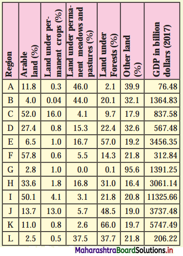
Maharashtra Board Class 12 Geography Solutions Chapter 7 Region and Regional Development 1
Answer:
Maharashtra Board Class 12 Geography Solutions Chapter 7 Region and Regional Development 2
X<sub>1</sub> = Land under permanent crops
Y<sub>1</sub> = GDP
R<sub>1</sub> = Rank – 1, R<sub>2</sub> = Rank – 2, n = 12 (No. of pairs)
Rank correlation R = 1 – \(\frac {6Σ(R_1-R_2)^2}{n(n^2-1)}\)
= 1 – \(\frac {6×118}{12(144-1)}\)
= 1 – \(\frac {708}{1716}\)
= 1 – 0.412
= 0.588
= 0.59

Maharashtra Board Class 12 Geography Solutions Chapter 7 Region and Regional Development 3
The answer of correction between (1) Land under permanent crops (2) GDP is 0.59 or +0.59 which means there is a positive correlation between these two variables.

It is not perfect positive correlation (+1.0). It is slightly less than this i.e. (+0.59).

It means when the amount of land under permanent crops is more, GDP is also more and when the amount of land under permanent crops is less, GDP is also less.

This is because the production of crops contributes to the growth of GDP.

The answer 0.59 suggests that this is not true for all countries as there are other factors, activities, products which are responsible for the growth of GDP other than the production of crops.

Maharashtra Board Class 12 Geography Solutions Chapter 7 Region and Regional Development

Class 12 Geography Chapter 7 Region and Regional Development Intext Questions and Answers

Try this

Question 1.
Given below are some geographical areas. Complete the table thinking about similarities between them and their types. Answer the questions that follow: (Textbook Page No. 66)
(i) While completing the above table how did you decide the common factor between these areas?
(ii) How did you differentiate one area from another?
(iii) Is the common factor the only basis of differentiation?
(iv) Make a list of characteristics which can be the basis of different area.
Answer:

Common factors / characteristicsTypes (political / physical)
Ganga river basin, Amazon river basin, Mississippi river basin, Nile river basinRiverPhysical
The Himalayan region, The Alps, The Western Ghats, The Rockies, The CaucasusMountainPhysical
Marathwada, Vidarbha, Khandesh, Konkan, Western MaharashtraAdministrativePolitical
The Thar Desert, The Arabian Desert, The Gobi Desert, The Sahar DesertDesertPhysical
Rajasthan, Madhya Pradesh, West Bengal, Kerala, ManipurAdministrative StatesPolitical
Pune, Bhopal, New York, Manchester, Munich, ShanghaiCitiesPolitical
Parbhani, Nagpur, Palghar, Kolhapur, SolapurAdministrative DistrictsPolitical
Hindi-speaking belt, Bengali-speaking belt, Marathi-speaking belt, Kannada-speaking belt, Urdu-speaking beltLanguagePolitical (Linguistic)
Delhi University, Punjab University, Mumbai University, Banasthali University CampusEducationSocial

(i) We decide on the basis of the function of each geographical area.
(ii) We differentiate one area from another on the basis of the type of physical, socio- cultural and political nature of the geographical areas.
(iii) Yes, the common factor is the only basis of differentiation.
(iv) Common basis is physical characteristics like river, desert, mountains, climate, soil, natural vegetation etc., and political characteristics like states, districts and cities and cultural characteristics like language, education, etc.

Maharashtra Board Class 12 Geography Solutions Chapter 7 Region and Regional Development

Question 2.
Here is the list of regions. Classify them into formal and functional regions. (Textbook Page No. 68)
Ujani Dam catchment area, area served by Pune Municipal Transport (PMT), area served by Citi Cable Service, Uttar Pradesh, District Kolhapur, Taluka Haveli, rice producing region of Konkan, Black cotton soil region of India, areas served by local trains of Mumbai, area served by a Primary Health Centre
Answer:

Formal RegionsFunctional Regions
(i) Uttar PradeshUjani Dam catchment area
(ii) District KolhapurArea served by Pune Municipal Transport (PMT)
(iii) Taluka HaveliArea served by Citi Cable Service
(iv) Rice producing region of KonkanArea served by local trains of Mumbai
(v) Black cotton soil region of IndiaArea served by a Primary Health Centre

Question 3.
In the following table, regions are given. At the same time, some geographical factors and effects are also given. Complete the table 7.3 accordingly, with the help of solved examples. (Textbook Page No. 69 & 70)
Answer:

RegionGeographical factorsEffects on the region
Nile River basinDeep and fertile soil, Sufficient water supply by river, Gently sloping landAgricultural Development, Development of Industries, Hydro-electricity project, Irrigation etc.
Canada, Norway, Sweden, Finland and Northern part of RussiaConiferous forest areas.Lumbering, Paper and pulp Industry, Furniture manufacturing industry, Saw mills, Deforestation, Landslides Flooding
JapanIsland location, Low mineral resources, Narrow geographical extentFishing, Development of trade, Industrial development, Hydel power projects
IndonesiaMalaysia Fertile volcanic soil, Beautiful sceneryAgricultural development, Trade, Tourism

Question 4.
Look at the land use of the following regions in Table 7.5 and answer the questions that follow: (Textbook Page No. 72)
(i) What does the table show?
(ii) Which region has the highest land use under agriculture?
(iii) Which region has the highest GDP?
(iv) Which country (region) has more land use under forest?
(v) Which region has the highest land use under category ‘other land’? What’s its GDP?
(vi) Write your conclusion in few sentences.
Answer:
(i) The table shows land use in different regions.
(ii) The region C has the highest land use under agriculture.
(iii) The region I has the highest GDP.
(iv) The country (region) K has more land use under forest.
(iv) The region G has the highest land use under category ‘other land’. Its GDP is 1391.5 billion dollars.
(v) The region I is having highest GDP in which there is 50% arable land, it means agriculture must be major activity.

The region A is having lowest GDP where land under permanent meadows and pastures is highest. It means there is limited development of agricultural activities.

It is surprising, region F where arable land is highest in percentage even then GDP is comparatively low, because the land under permanent crop is very less.

In region K, GDP is 5747.49 and land under forest is 66%. It must be because the development of lumbering activities and forest-based industries is greater.

The region G has the highest area under other land use (95.6%) and GDP 1391.25. This region must have developed activities other than agriculture and forestry.

Maharashtra Board Class 12 Geography Solutions Chapter 7 Region and Regional Development

Use your brain power!

Question 1.
Can you tell what the identifying characteristic in the following regions?
(i) Pune Metropolitan Region
(ii) Nagpur hub
(iii) Dal Lake in Srinagar
(iv) Alleppey tourism centre
Answer:
(i) Pune Metropolitan Region – Functional region – Administration
(ii) Nagpur hub – Functional region – Industrial complex
(iii) Dal Lake in Srinagar – Functional region – Tourism
(iv) Alleppey tourism centre – Functional region – Tourism

Question 2.
(i) Identify your formal region.
(ii) Can you identify and demarcate your own functional region?
(iii) Which one is larger? (Textbook Page No. 68)
Answer:
(i) Maharashtra State
(ii) Yes, I can identify my functional region as government milk centre or D-mart departmental store.
(iii) Area served by D-mart departmental store is larger than the government milk centre.

Can you tell?

Question 1.
Read the table and answer the questions that follow. (Textbook Page No. 69)
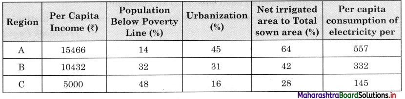
Maharashtra Board Class 12 Geography Solutions Chapter 7 Region and Regional Development 4
(i) In which region do you think there are more resources available?
(ii) In which region do you think people are richer?
(iii) In which region do you think people may be happier? Why?
(iv) Do you think the given indicators or factors are enough to decide the standard of living of the people in the region?
(v) In which region would you like to stay? Why?
Answer:
(i) I think in region A more resources are available.
(ii) I think in region A people are richer.
(iii) People may be happier in region A because of higher per capita income, less population below poverty line, more urbanisation, more net sown area under irrigation.
(iv) I do not think the given indicator or factors are enough to decide the standard of living because other important factors like literacy rate, enrolment ratio / dropout ratio, sex ratio, crime rate etc., are not taken into consideration
(v) I will like to stay in region A because in this region per capita income is high, population below poverty line is low, percentage of urbanisation is highest, net sown and irrigated area is highest.

Maharashtra Board Class 12 Geography Solutions Chapter 7 Region and Regional Development

Question 2.
(i) Looking at the five stages of demographic transition theory, countries in which stage do you think, will be called developed?
(ii) Having looked at the various shapes of pyramids, which pyramid will represent a developed country? (Fig 2.1, Textbook Page No. 12)
(iii) After having answered both the questions above, what can you comment upon the role of population in regional development? (Textbook Page No. 70)
Answer:
(i) Countries in stage 4 and 5 will be called developed for e.g., USA, Sweden, Finland.
(ii) The pyramid (C) will represent a developed country.
(iii) The role of population in the regional development of any country is very important as man is a human resource. Quality of human resources is very important, which depends upon birth rate, death rate, expectancy of life, literacy ratio, male female ratio, mortality rate, etc.

A country having to qualitatively better population will help in the regional development of that country. For example, qualitatively population of the USA is better than population of India and hence, in USA there is better regional development than India.

Think about it

Question 1.
(i) Does development mean maximum utilisation of resources?
(ii) Does development consider environment as an indicator?
(iii) Can a region be called developed if it has sparse population or no population? (Textbook Page No. 69)
Answer:
(i) Development does not mean maximum utilisation of resources. Development of a region is the function of its resources and its population. There are many factors which affect the development of a region. For the holistic development of regions, skilled human resources and optimum utilisation of natural resources is necessary.

(ii) We must consider the environment as an indicator of development. Development at the cost of the environment is not real development. Since we ignore the environment while developing economy in the past 50 years, we are now suffering by many environment problems like global warming, etc.

(iii) Population is one of the most important factors in development. If there is sparse population or no population, then there will be shortage of man-power and resources will remain unutilized and therefore, quantity and quality of human resources is very important in the process of development.

Give it try

Question 1.
Draw a conclusion on the basis of the data given in table 7.4. Use Spearman’s Rank Correlation, find the correlation between the two variables. What can you comment about the development in this region? (Textbook Page No. 71)
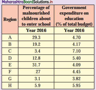
Maharashtra Board Class 12 Geography Solutions Chapter 7 Region and Regional Development 5
Answer:
Maharashtra Board Class 12 Geography Solutions Chapter 7 Region and Regional Development 6
X<sub>1</sub> Percentage of malnourished children about to enter school.
Y<sub>1</sub> Government expenditure on education (% of total budget)
R<sub>1</sub> = Rank – 1, R<sub>2</sub> = Rank – 2, n = 8
Rank correlation R = 1 – \(\frac {6Σ(R_1-R_2)^2}{n(n^2-1)}\)
= 1 – \(\frac {6×10⁴}{8(64-1)}\)
= 1 – \(\frac {624}{8(63)}\)
= 1 – \(\frac {624}{504}\)
= 1 – 1.24
= -0.24

The correlation between the percentage of malnourished children about to enter school and government expenditure on education is -0.24.
This value is very near to zero, which means no correlation. Hence, it is very slightly a negative correlation.

Maharashtra Board Class 12 Geography Solutions Chapter 7 Region and Regional Development 7

It means where the percentage of malnourished children about to enter school is more, the government expenditure on education is less e.g., in E region percentage of children is 31.7% but the expenditure is 4.09% and in C region percentage of children is only 3.4% but the expenditure is 7.10% (highest).

Considering the fact, we cannot consider this as well developed. There is no logical sequence in distribution of government expenditure on education. It is necessary that government authorities should take into consideration actual status of the region, need of the region before releasing grant to that region. This will surely help in proper allocation of the funds and overall development of the region.

Maharashtra Board Class 12 Geography Solutions Chapter 7 Region and Regional Development

Question 2.
Go through the fig. 7.2 and write two sentences on each factor. Tell how they will help in reducing regional imbalance. Also add some more to the list, if necessary. (Textbook Page No. 73)
Answer:
No country, in the world is having uniform regional development and thus, there is regional imbalance in development. Hence, a country must have a regional imbalance reduction strategy. Regional imbalance can be reverted through provision of public/services to backward areas by providing drinking water, education facilities and electricity to all.

It can also be reverted by making provision of infrastructure stimulus by allotment of special funds, development of special skills, good governance, support to infrastructural project and policy review and reform.

Question 1.
Look at the following data and answer the questions that follow: (Textbook Page No. 72)
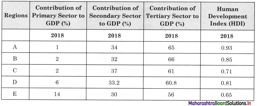
Maharashtra Board Class 12 Geography Solutions Chapter 7 Region and Regional Development 8
(i) In which region is contribution of primary activities the least?
(ii) In which region is the contribution of primary activities the most?
(iii) In which region the contribution of tertiary activities is the most?
(iv) Which region has the highest HDI?
(v) Can you draw a conclusion on basis of the answers from Q (i) to Q (iv)?
Answer:
(i) In region A, the contribution of primary activities is the least.
(ii) In region E, the contribution of primary activities is the most.
(iii) In region B, the contribution of tertiary activities is the most.
(iv) In region A, there is highest HDI.
(v) We can conclude by saying that Human Development Index is high in countries where contribution of secondary and tertiary sector to GDP is high compared to the contribution of primary sector to GDP.

Region A, B, C and D have more than 30% contribution of secondary sector to GDP and more than 60% contribution of tertiary sector to GDP, it means these regions are developed regions.

The contribution of primary sector to GDP in region E is more but the contribution from secondary and tertiary sector is less compared to other regions, so region E is in the developing stage.

Maharashtra Board Class 12 Geography Solutions Chapter 8 Geography: Nature and Scope

Balbharti Maharashtra State Board Class 12 Geography Solutions Chapter 8 Geography: Nature and Scope Textbook Exercise Questions and Answers.

Maharashtra State Board Class 12 Geography Solutions Chapter 8 Geography: Nature and Scope

1. Identify the correct group.

Question 1.

ABCD
GeomorphologyCartographyTourismPolitical Geography
ClimatologySurvey  ForestConservationPhysical Geography
BiogeographyData collectionWildlife ConservationPopulation Geography
Historical GeographyGIS/GPSCulture ConservationEconomic Geography

Answer:
B

Maharashtra Board Class 12 Geography Solutions Chapter 8 Geography: Nature and Scope

Question 2.

ABCD
HistoryEconomicsBiogeographyGeomorphology
SociologyGeologyPopulation GeographyGIS
DemographyRemote sensingCartographyDemography
Political ScienceClimatologyPsychologyPedology

Answer:
A

2. Give geographical reasons.

Question 1.
Human Geography is multidisciplinary in nature.
Answer:

  • Human geography is the branch of geography dealing with human activities and their influence on culture, communities and economies.
  • In human geography every social science studies separately has interface with branch of human geography; because of their spatial attributes.
  • Social sciences like sociology, political science, economics, history and demography are very closely related with branches of human geography, such as social geography, political geography, economic geography and historical geography, respectively.
  • Since, we study varied branches of geography in human geography, it is said to be multidisciplinary in nature.

Question 2.
Geography is dynamic in nature.
Answer:

  • Most geographical phenomena whether physical or human are not static and can change overtime.
  • In economic geography, we study economic activities as well as factors affecting their distribution and changes.
  • In climatology we study changes in temperature and rainfall due to global warming. Depending upon the changes in climate, changes are made in cropping patterns.
  • Geographers study relationship between production, distribution and geographical factors.
  • For example, tea is grown on a large scale in the State of Assam due to high temperature, heavy rainfall, red soil, hilly relief, cheaper water transportation due to the Brahmaputra River and cheap and skilled labour supply from nearby States of Bihar and Orissa.
  • We study weather over a period of about 30 years and decide climate of that place or population of a country or the world over a period of time. Since, changes occur time to time.
    Thus, geography is dynamic in nature.

Question 3.
Geography is dualistic in nature.
Answer:

  • There are two contrasting approaches to study the subject of geography. They are possibilism and environmental determinism. This contrast in approaches is called as dualism in geography.
  • Some geographers are of the view that nature is more dominant than man. It is called environmental determinism. According to them, when we study geography, we study the earth. We study how natural resources have influence on economic activities, as well as food habits of people.
  • For example, in coastal areas fishing activity is more developed and fish is the main food of the people.
  • Some geographers are of opinion that man dominates the nature. It is called possibilism. According to them man can make changes in nature due to his intelligence.
  • For example, there are polyhouses even in polar areas, in which temperature is controlled artificially and vegetables are grown.
  • There are many other thinkers who have different approaches in geography.
    Thus, the study of geography is dualistic in nature.

Maharashtra Board Class 12 Geography Solutions Chapter 8 Geography: Nature and Scope

3. Write short notes on.

Question 1.
Physical Geography is related to various branches of science.
Answer:

  • Almost every discipline, under natural and social sciences is linked with geography.
  • Geomorphology, Climatology, Oceanography and Biogeography are the branches of physical geography.
  • Geomorphology studies landforms, rock types, processes of formation of rocks, landforms, etc. Therefore, it is related to geology.
  • Climatology studies elements of atmosphere such as temperature, winds, rainfall, humidity, natural disasters like cyclones, anticyclones, storms, etc. Therefore, it is related to meteorology.
  • Oceanography studies oceans and seas on the surface of the earth, ocean currents, ocean routes, etc. Therefore, it is related to Hydrology.
  • Biogeography studies the distribution of plants and animals, their species, ecosystems, etc. Therefore, it is related to biology.
  • Knowledge of mathematics is important for cartographic techniques, such as drawing of maps and diagrams. Similarly, knowledge of statistics is useful to do data analysis since various statistical techniques and hypotheses testing are used in data analysis.
  • Thus, physical geography is related to various branches of sciences.

Question 2.
Branches of Geography.
Answer:

  • There are three major branches of Geography – Physical Geography, Human Geography and Geographic Techniques.
  • Geography has various sub-branches; however, the four major sub-branches of Physical Geography are Geomorphology, Climatology, Biogeography and Oceanography.
  • Human geography comprises of six sub-branches, Historical Geography, Political Geography, Economic Geography, Behavioural Geography, Social Geography and Population Geography.
  • Geographic Techniques have four branches, namely, remote sensing, quantification methods in geography, cartography and Geographic Information System (GIS).

Question 3.
Latest trends in Geography.
Answer:

  • Currently, the explanation of all geographic phenomena depends upon the cause and effect relationship.
  • Geographers developed number of disciplines within its boundaries.
  • Number of techniques for analysis and prediction through data collection and modelling are also developed by geographers.
  • Due to the dynamic nature of geography, new things are added in the subject.
  • Use of audio-visual media and information technology has enriched the database.
  • The latest technology of software has brought about better opportunities in data collection, interpretation, analysis and presentation.
  • Presently, the Use of GIS and GPS has become essential. Therefore, maps are made by using GIS software and have proved to be more accurate.
  • Nowadays the use of mathematical modelling and computer models in applied geography has increased. They are used for prediction of weather changes or natural calamities.
  • The above mentioned are all the latest trends in Geography.

Question 4.
Skills required for studying geography.
Answer:

  • The skills required to study the methods and techniques used in geography have made the study of geography empirical and practical in nature.
  • The study of geography is based on theory and observation. It is supported by the scientific study like data collection and data analysis through number of tools and techniques.
  • The geographers developed skills for conducting surveys with the help of advanced technology. They have also acquired the skills to make use of satellite images for data collection.
  • The geographers have attained the skills for experiments, data collection, data organisation, observation patterns, data analysis, research findings, etc.
  • The geographers have learnt analytical techniques of data with the help of statistical techniques and representation of statistical data using graphs and maps.

Maharashtra Board Class 12 Geography Solutions Chapter 8 Geography: Nature and Scope

4. Answer the following questions in detail.

Question 1.
Explain how the knowledge of Geography is important in our day-to-day life. Give examples.
Answer:

  • The knowledge of geography is important in our day-to-day life because with geographical knowledge we can understand the basic physical systems that affect our everyday life.
    For example, the earth-sun relationship, water cycle, wind, ocean currents, etc.
  • For the effective functioning of different places, we learn the physical and cultural characteristics of places.
  • With the help of geography, we can understand the geography of the past, how geography had played an important role in the evolution of people, their ideas, places and environment.
  • We can prepare a map of a province or territory, country and the world, so that one can understand the location of various countries. For example, the political map of the Asian continent gives idea about location of Asian countries.
  • With the help of various distribution maps, we can understand distribution of minerals, crops, population, etc., in the world. For example, with the help of dot map we can understand spatial distribution of population in the world.
  • With the help of economic geography, we can understand the development of economic activities in different countries of the \yorld and their correlation with physical and economic factors. For example, we can study the world’s leading areas in fishing activities and their reasons.
  • With the help of climatology, we understand atmospheric phenomenon, such as cyclones, global warming, etc.
  • The study of sustainable development in geography teaches us to appreciate the earth as humankind’s homeland and provide an insight for wise management decisions about the usage of the earth’s resources.
  • With the help of geography, we can understand global inter-dependence to become a better global citizen.
  • Thus, with the help of geography, we can study physical features, economic activities, trade, people, etc., in the world.

Question 2.
Discuss the relationship between Geography and other subjects.
Answer:

  • Geography is related to almost every discipline under natural and social sciences. There are three major branches of Geography, namely, Physical Geography, Human Geography and Geographic Techniques.
  • Geography has various sub-branches; however, the four major sub-branches of Physical Geography are Geomorphology, Climatology, Biogeography and Oceanography.
  • In Geomorphology we study the formation and types of landforms, gradient, rock structure, etc. This is related to the subject of geology.
  • In Climatology we study the atmospheric elements such as temperature winds, rainfall, humidity, natural disasters like cyclones, anticyclones, storms, etc. This it is related to the subject of meteorology.
  • In Oceanography we study the ocean currents, ocean routes, coastal features, submarine relief, etc., of oceans and seas. This it is related to the subject of hydrology.
  • In geography of soil, we study the components, layers, texture, and fertility of the soil, etc. This is related to the subject of pedology.
  • Human geography comprises of six sub-branches, Historical Geography, Political Geography, Economic Geography, Behavioural Geography, Social Geography and Population Geography. In historical geography, we study the correlation of historical events with geographical factors. This is related to the subject of history.
  • In Political Geography, we study the effect of geographical factors on political events. This is related to the subject of political science.
  • In Economic Geography, we study the correlation of geographical factors and economic activities. This is related to the subject of economics.
  • Similarly, Behavioural Geography, Social Geography and Population Geography are related to the subjects of psychology, sociology and demography respectively.
  • Thus, it can be concluded by saying that geography has a strong relationship with other subjects in natural as well as human or social sciences.

Maharashtra Board Class 12 Geography Solutions Chapter 8 Geography: Nature and Scope

Question 3.
Explain the nature of Geography in detail.
Answer:

  • Geography is the study of the earth as a home of man, and various phenomena related to it.
  • Therefore, geography is the study of the physical environment in relation to man. The physical environment has direct effect on cultural and social environments.
  • The earth is dynamic in nature. Hence, we find variations in its physical and cultural/social environments.
  • In geography we study the relation between the physical environment and production, distributions and their patterns and variations.
  • Geographers study the location, geographical phenomena, whether physical or human, which are highly dynamic and its causes.
  • Since geography is the study of space and time it makes geography dynamic in nature.
  • In geographical study, the geographer tries to answer questions like what, why, where and when.

5. Differentiate between.

Question 1.
Physical Geography and Human Geography
Answer:

Physical GeographyHuman Geography
(i) Physical Geography is the branch of geography dealing with natural features.(i) Human Geography is the branch of geography dealing with how human activities influence the culture, communities, economies, etc.
(ii) Geomorphology, Climatology, Oceanography, Biogeography, Geography of soils, are the branches of Physical Geography.(ii) Historical Geography, Political Geography, Economic Geography, Behavioural Geography, Social Geography and Population Geography are the branches of Human Geography.
(iii) Physical geography is natural science.(iii) Human geography is a social science.

Question 2.
Possibilism and Determinism.
Answer:

PossibilismDeterminism
(i) When man dominates nature, it is called possibilism.(i) When nature dominates man, it is called determinism.
(ii) Due to intelligence, man makes changes in the natural environment.(ii) Determinism asserts that development of human history, culture, society, lifestyle, etc., are shaped by their physical environment.
(iii) There are limitations to changes made by man in nature.(iii) There are no limitations on impact of physical environment on human activities.

Maharashtra Board Class 12 Geography Solutions Chapter 8 Geography: Nature and Scope

6. Draw a neat and well-labelled diagrams

Question 1.
Relationship between Geography and other subjects.
Answer:
Maharashtra Board Class 12 Geography Solutions Chapter 8 Geography Nature and Scope 1

Question 2.
Skills required to study Geography.
Answer:
Maharashtra Board Class 12 Geography Solutions Chapter 8 Geography Nature and Scope 2

Class 12 Geography Chapter 8 Geography: Nature and Scope Intext Questions and Answers

Let’s recall

Question 1.
Dear students, you have been studying geography either as a part of Environmental Studies since Standard III or as Social Studies since Standard VI and as an independent subject since Standard XI. Your journey to understand our homeland earth began with the study of the cardinal directions in Standard III. In the consecutive academic years, you learnt various geographical concepts. Now just recall the various concepts that you have learnt till now and make a list of them. Also classify them under different categories given in the table 8.3. (Textbook Page No. 75)
Answer:
Maharashtra Board Class 12 Geography Solutions Chapter 8 Geography Nature and Scope 3

Maharashtra Board Class 12 Geography Solutions Chapter 8 Geography: Nature and Scope

Can you tell?

Discuss the following points in class with reference to its importance in the subject matter of Geography. (Textbook Page No. 77)
Question 1.
Environment vs. Man
Answer:
Man and environment are inter-related. The environment influences the life of human beings who in-turn modifies the environment as a result of their growth, dispersal, activities, death, etc. Thus, all living beings including man and their environment are mutually reactive affecting each other in a number of ways and a dynamic equilibrium is possible between the two, i.e., human beings and environment are interdependent. If the natural environment helped in the development of different structures of the society on the one hand, the existence and quality of environment now rests on the responses of these social structures to the environment on the other hand.

The burning issues like quality of environment, disruption of earth’s natural ecosystems, environmental degradation and pollution, ecological imbalances, depletion of resources, etc., can be approached and solved only after considering the value judgments which may be determined by taking into account the consequences of ‘Environmental Improvement Programme’ on the entire society and society’s response towards the programme. However, all these depend on the interest and desire of the society in improving the quality of environment.

The interaction between the environment and man depends largely on the social and political system. The differential interactions are due to the uneven distribution of natural resources, uneven economic and social development, dissimilarities of demographic factors, varying view points of the governments and individuals towards the environment, etc.

Continuous and exceedingly increasing rate of exploitation of natural resources, industrialisation, technological growth, unplanned urbanisation and profit-oriented capitalism by the developed western world are responsible for grave environmental crisis and ecological imbalance not confined to their own countries but to the whole world.

The changes in the relationship between man and environment depend upon the change in organisation and attitude of man. To improve environmental stand and to maintain ecological balance, the following remedies are important

  • Rapid growth of population
  • Rational use of non-polluted water resources
  • Use of organic fertilizers for agricultural growth
  • To check soil erosion
  • Restoration of forest resources
  • To check pollution

Maharashtra Board Class 12 Geography Solutions Chapter 8 Geography: Nature and Scope

Question 2.
Complete study of India vs. Study of only agriculture in India.
Answer:
[Note: In India, it is not possible to provide a complete study of India and agriculture within the scope of a book.]

Try These

Question 1.
Given here are some of the concepts or subject matter we study in Geography. Write the name of subjects or disciplines you think they are also studied in. Complete the table 8.2. (Textbook Page No. 78)
Maharashtra Board Class 12 Geography Solutions Chapter 8 Geography Nature and Scope 4
Answer:

ConceptsSubject in which the concept is also studied
Calculations involved in projections, shapes of projectionsCartography
Means of livelihood: agriculture, industry, trade, etc.Economics – Economic Geography
Cost of production, GDP, incomes, resources, scarcity, etc.Economics – Economic Geography
Social relations and inequalities.Sociology – Social Geography
Racial structure of humans, evolution of humans, etc.Anthropology -Human Geography
Rocks and mineralsGeology – Geomorphology
Behaviour of humans in different climates and topography.Psychology – Behavioural Geography
Electoral divisions, voting patterns, types of governmentsPolitics – Political Geography
Biomes, food chain, forests, etc.Biology – Biography
Chemical weathering, erosion, acid rain, etc.Geography – Physical Geography
Mean, variance, correlation, regression, etc.Statistics – Statistical Geography
Past of different places, their development before attaining the present-day status, etc.History – Historical Geography

Maharashtra Board Class 12 Geography Solutions Chapter 8 Geography: Nature and Scope

Question 2.
In Fig 8.5, a newspaper item is given. A list of job opportunities is given. Go through all the entries and see which ones are suitable for a geographer as a career. (Textbook Page No. 80)
Maharashtra Board Class 12 Geography Solutions Chapter 8 Geography Nature and Scope 5
Answer:
The following is the list of jobs opportunities suitable for a geographer as a career.
(i) National Atlas of Thematic Mapping Organisation of India.
(ii) Mumbai Mahanagar Palika, Department of Urban Planning, Mumbai, as Urban Planner
(iii) Assistant Professor in the subject of Geography
For all above posts basic qualification is minimum M.A./M.Sc. in Geography.

Maharashtra Board Class 12 Geography Solutions Chapter 5 Secondary Economic Activities

Balbharti Maharashtra State Board Class 12 Geography Solutions Chapter 5 Secondary Economic Activities Textbook Exercise Questions and Answers.

Maharashtra State Board Class 12 Geography Solutions Chapter 5 Secondary Economic Activities

1. Complete the Chain

Question 1.

ABC
(1) Small scale industries(1) Manual manufacturing(1) Ceramics
(2) Cottage industries(2) Skilled crafts person(2) Tata Iron and Steel company
(3) Consumer goods(3) Individual(3) Potters
(4) Private(4) Ready for direct consumption(4) Pharmaceutical

Answer:

ABC
(1) Small scale industries(1) Ready for direct consumption(1) Potters
(2) Cottage industries(2) Manual manufacturing(2) Ceramics
(3) Consumer goods(3) Skilled crafts person(3) Pharmaceutical
(4) Private(4) Individual(4) Tata Iron and Steel company

Maharashtra Board Class 12 Geography Solutions Chapter 5 Secondary Economic Activities

2. Identify the correct correlation.

A : Assertion, R : Reasoning
Question 1.
A – The humid climate of Mumbai offered great scope for the development of cotton textile industries.
R – Industries require ample amount of water.
(a) Only A is correct.
(b) Only R is correct.
(c) Both A and R are correct and R is correct explanation of A.
(d) Both A and R are correct but R is not the correct explanation of A.
Answer:
(d) Both A and R are correct but R is not the correct explanation of A.

Question 2.
A – In India, industries are found concentrated in few areas are available.
R – India is predominantly agrarian country.
(a) Only A is correct.
(b) Only R is correct.
(c) Both A and R are correct and R is correct explanation of A.
(d) Both A and R are correct but R is not the correct explanation of A.
Answer:
(c) Both A and R are correct and R is correct explanation of A.

3. Give geographical reasons.

Question 1.
Distribution of industries is uneven.
Answer:

  • Distribution of industries depend upon various physical factors like climate, raw material, water and power supply, labour, transportation, land, etc., and economic factors like capital, market and government policies.
  • Physical and economic factors vary from region to region and political factors vary from country to country.
  • Industries are developed where physical and economic factors are favourable for their development.
  • Thus, distribution of industries is uneven.
  • For example, in India industries are concentrated in Mumbai, Chennai, Kolkata, Delhi, Chota Nagpur region and in the rest of India, agriculture is the only major economic activity.

Question 2.
Iron and steel industries are found in mineral rich area of Dhanbad.
Answer:

  • Important raw materials used in iron and steel industry are iron-ore, limestone, dolomite, manganese and coal.
  • All these raw materials are heavy, bulky and weight-loosing.
  • The cost of transportation of these materials are very high.
  • Dhanbad and its surrounding areas are the major iron-ore and coal producing areas.
  • • Since this industry is using weight-losing raw materials which are available around Dhanbad, iron and steel industry is found at Dhanbad.

Question 3.
Fruit-processing industries are found in Ratnagiri and Sindhudurg districts of Konkan region.
Answer:

  • Fruit processing industries use fruits as raw material.
  • Ratnagiri and Sindhudurg districts are known for horticulture. They are major mango, jackfruit, cashew and kokum producing districts of Maharashtra.
  • All these fruits are raw materials in fruit processing industry.
  • These raw materials are bulky, weight-losing and perishable and hence the industry is located in Ratnagiri and Sindhudurg districts where fruits are grown in plenty.

Maharashtra Board Class 12 Geography Solutions Chapter 5 Secondary Economic Activities

Question 4.
What are the major factors which have hindered the growth of industries in South America?
Answer:

  • Industries in the continent of South America are developed only in coastal areas of Brazil, Argentina, Chile and Peru.
  • The hindrances in the growth of industries in South America are due to unfavourable physical factors such as dense forests in Brazil, deserts in interior parts of Argentina, Andes mountain range running along the west coast.
  • The economic factors like limited capital, lack of modern technology and lack of transportation facilities etc., create hindrance in development of industries.
  • Comparatively low density of population and lack of markets are the other factors responsible to have hindered the growth of industries in South America.

4. Write short notes on.

Question 1.
Footloose industries.
Answer:

  • Footloose industry is a general term for an industry that can be placed and located at any location without effect of factors of location such as land, labour, climate and capital.
  • The raw material used as well as finished products of these industries are very light so their location near the source of raw material or transport is not important.
  • These industries often have spatially fixed cost, which means that costs of the product do not change despite where the product is assembled.
  • Diamond cutting, computer chips and mobiles manufacturing are some of the examples of footloose industries.
  • Advance technology like internet, email are used for raw material as well as marketing.
  • These are generally non-polluted industries.

Question 2.
Public sector industries.
Answer:

  • Public sector industries are owned by the state.
  • The investments in public sector industries is done by the government. Also, marketing of goods is done through government agencies.
  • Public sectors include public goods and governmental services such as military, law enforcement infrastructure (public roads, bridges, tunnels, water supply electrical grids, health, etc.).
  • Bharat Heavy Electrical Limited (BHEL) is one of the largest engineering and manufacturing companies of its kind in India engaged in designing engineering construction.

Question 3.
Economics of scale.
Answer:
1. Economics of scale are the cost advantages that enterprises obtain because of various facilities
established due to basic industries in certain region.

2. Sometimes due to advantage of many favourable factors for industrial development in certain areas, there is concentration of industries in that area, which is called agglomeration of industries.

3. In these regions industries develop not due to any locational factors but due to economies of scale enjoyed because agglomeration of industries.

4. Due to the development of basic industries other ancillary industries which are complementary to each other also develop. For example, once cotton textile industry develops in any region, readymaide garment making industries, industries supplying dyes and chemicals, industries producing materials like thread, buttons, laces, etc., also develop.

5. Due to such agglomeration, the industries in that region get more profit compared to their investment due to economies of scale such as cheap transport, labour, financial facilities etc. For example, transport companies give concession, hence, the cost of transportation decreases.

6. Since industries in this region are complementary, it is easier to collect or supply goods from other industries of nearby areas. For example, dye making industries supply dyes to cotton textile industry and cotton textile industry supplies cloth to ready-made garment industries.

Maharashtra Board Class 12 Geography Solutions Chapter 5 Secondary Economic Activities

Question 4.
Role of transportation in industries.
Answer:

  • Transportation facilities are important for the collection of raw materials and distribution of finished products.
  • Low cost of transportation is the key factor in the location of industries.
  • Transport network is crucial for sustained economic growth and development of a nation.
  • Transport system helps to send raw material, fuel and machinery to different industries at the right time and runs the industry.
  • Thus, transport plays a crucial role in the development of industries.

5. Differentiate between.

Question 1.
Weight-losing and Weight-gaining Industries.
Answer:

Weight-loosingWeight-gaining
(i) Weight-losing industries are those industries in which raw material are relatively bulky but finished products are relatively light.(i) Weight-gaining industries are those industries in which raw materials are relatively lighter than finished products.
(ii) Weight-losing industries are located near raw materials.(ii) Weight-gaining industries are located near markets.
(iii) For example, sugar industries locate near sugarcane producing areas. 10 tons of sugarcane is required to produce 1 ton of sugar.(iii) For example, cotton textile industries locate near the market because finished product cotton cloth is heavier than the raw material cotton.

Question 2.
Primary and Secondary Activities.
Answer:

Primary ActivitiesSecondary Activities
(i) Primary activities include activities, such as hunting, fishing, mining, agriculture.(i) Secondary activities include manufacturing and constructions.
(ii) These activities are concerned with obtaining materials directly from nature. For example, fish from water or wood from trees.(ii) These activities add value to the already existing products by changing their form, making them more suitable to satisfy our needs and wants.
(iii) Primary activities produce raw materials.(iii) Secondary activities produce finished products.
(iv) Production of goods in primary activities depends upon natural factors.(iv) Production of goods in secondary activities depends on technology, skill of labours and capital.

Maharashtra Board Class 12 Geography Solutions Chapter 5 Secondary Economic Activities

Question 3.
Basic Industries and Consumer Industries.
Answer:

Basic IndustriesConsumer Industries
(i) The finished products of these industries are used by other industries.(i) The finished products of these are used as raw material which are directly consumed by consumers.
(ii) For example, iron and steel industry provides steel as raw material to machine tool making or agricultural implements making industry.(ii) For example, the medicines made in pharmaceutical industries are directly consumed by consumers.
(iii) These industries supply their products to others. Hence, they are called linkage products.(iii) These industries supply their products to consumers. Hence, they are called as consumer goods industries.

6. Answer the following questions in detail.

Question 1.
Explain the physical factors affecting location of industries.
Answer:
Climate, raw material, water, power, labour, land and transport are important physical factors deciding the location of industry.

Extreme climate like too hot, too cold, dry and very humid climate are not suitable for industries. Generally, industries develop in areas of moderate climate.

Availability of raw material is essential for the development of industries. Industries using perishable, heavy, bulky and weight-losing raw materials are located in the areas of source of raw materials. For example, sugar mills near sugarcane growing areas.

Most of the industries require lot of water for processing, like cooling, washing etc. Such industries are located near lakes, rivers or other water bodies. For example, many industries are located around Great Lakes in USA.

Labour is another important factor deciding location of industries. Availability of skilled, semi-skilled and cheap labour is very important to work in industries. Hence, we generally find labour colonies are located where skilled and cheap labour is available.

Transport facilities are essential for transport of raw materials and finished products. Low cost transport is the key factor in the development of industries. Industries develop in the areas, where transportation network is well developed. For example , many industries are developed along Trans-Siberian railway line in Russia.

Industrial development need huge land for the construction of industrial units. Industries develop where cheap, plain and extensive land is available.

Industries need power supply, main sources of power supply are coal, oil, electricity and now a days wind energy, solar energy etc. Industries locate near coal mines, or availability of electricity. For example, industries concentrated around coal mining area of Ruhr region of Germany or industries concentrated near Khopoli hydro power station.

Maharashtra Board Class 12 Geography Solutions Chapter 5 Secondary Economic Activities

Question 2.
Explain the factors affecting location of sugar industries.
Answer:
The following are the factors affecting the location of sugar industries.

  • Sugar industry is and agro-based industry.
  • Sugarcane is the raw material in sugar industry.
  • Sugarcane is perishable and weight-losing raw material.
  • It is also heavy and bulky raw material.
  • Taking into consideration all above characteristics of raw material used in sugar industry, it is always located in the areas of sugarcane production.
  • In Maharashtra, Satara, Kolhapur, Ahmednagar, Sangli etc., are the sugarcane producing districts and the same districts have concentration of sugar industry.

Question 3.
Explain the economic and political factors affecting location of industries.
Answer:
The following are the economic factors affecting the location of industries.
1. Neatness to market : Transport cost is one of the important costs included in production cost of goods. If industries locate near the market there is saving on transport cost and goods reach to the consumers as early as possible. Some industries whose finished products are perishable or bulky or heavy, locate near the market. For example, ice cream making, furniture making or air craft making industries.

2. Availability of capital : Capital is required for land, construction, equipment, labour, transport etc. Therefore, industries are located in areas where banking and financial facilities are available. Generally, these facilities are available in big cities, therefore in India many industries are located in big cities like Mumbai, Chennai, Bengaluru, Ahmedabad, Kolkata etc.

The following are the political factors affecting the location of industries.
Government policies : The government policy of encouragement or discouragement directly affects location of industry.

  • Sometimes government gives encouragement for development of industries in economically backward areas or to reduce the overcrowding in nearby cities by providing land, water, power at cheaper rate. For example, to reduce the overcrowding in Mumbai city, the government provided land, water, electricity at a cheaper rate in Navi Mumbai.
  • The government policy regarding import, export, taxes, subsidies, etc., also affect location of industries. For example, liberal policy for industries in the State of Gujarat attracted many industrialists to set up industries.
  • Development of SEZ : Due to the development of Special Economic Zone (SEZ) many industries are attracted in SEZ area. SEZ are developed to set up public sector or private sector industries, specially to increase export quality production in the country.

7. Show the following on a map of the world with suitable index

(1) Ruhr industrial region
(2) An industrial region in Japan
(3) An industrial region in South Africa
(4) An industrial region in Australia
(5) Industrial region near Great Lakes
Answer:
Maharashtra Board Class 12 Geography Solutions Chapter 5 Secondary Economic Activities 1

Class 12 Geography Chapter 5 Secondary Economic Activities Intext Questions and Answers

Observe the pictures given in the textbook figure. Identify the activities with which these figures are associated and complete the table.
Maharashtra Board Class 12 Geography Solutions Chapter 5 Secondary Economic Activities 2
Answer:
Maharashtra Board Class 12 Geography Solutions Chapter 5 Secondary Economic Activities 3

Try These

Question 1.
Look at the map of Solapur district. It shows the location of some sugar industries. Shamrao is a farmer at location A. He has just harvested his sugarcane crop. Study the map and tell where should he send his crop? What factors will Shamrao consider for this? (Textbook Page No. 43)
Answer:
(i) Shamrao has two options, he can sell his sugarcane to Pimpalner Sugar Factory or Virag Sugar Factory, since both the factories almost at equal distance from A.
(ii) The most important factor of consideration is the distance and perishability of sugarcane as a raw material.
(iii) Third factor he should take into consideration is from A, the road condition. The factory to which he should send sugarcane must be in good condition; so that sugarcane can be transported to industry as early as possible.

Maharashtra Board Class 12 Geography Solutions Chapter 5 Secondary Economic Activities

Question 2.
Firoz’s son has done an advanced course in Bakery Management from the nearby city. He wants his son to start a bakery in their village but his son says it should be in the city, which is around 20 kms from their village. Who is correct? Firoz or his son? Why? (Textbook Page No. 44)
Answer:
The decision of Firoz’s son is correct. He should start a bakery in the city. First thing is that bakery products are perishable and secondly there is loss of weight of raw materials in the production of bakery products.

Question 3.
Shantaram is a young boy from a tribal area in Maharashtra. He wants to start a honey processing unit as he has access to good honeycombs in the forest. The city is around 35 kms away. He has his own land in the village and is also getting land in the cit3\ Where should he establish the honey factory? In the village or in the city? Why? (Textbook Page No. 44)
Answer:
(i) Shantaram should start his honey factory in the city. Raw material in his factory will be honeycombs.
(ii) From honeycombs he will get two finished products – honey and wax. The weight of honeycombs after extracting honey and wax will be the same and therefore ideal location is city.

Can you tell?

Question 1.
Find example of market-oriented industries. (Textbook Page No. 45)
Answer:
(i) All textile industries are market-oriented industries Cotton Textile, Silk Textile, Woollen Textile.
(ii) All assembly industries are market-oriented industries Automobile, Air-craft, shipbuilding industries.

Use your brain power!

Question 1.
Following is a list of few industries. Think about the factors of location of these industries and tell whether they are footloose industries or not. Complete the table accordingly. (Textbook Page No. 47)
(i) Cotton textile industries
(ii) Cement industries
(iii) Diamond industries
(iv) Mobile manufacturing units
(v) Paper industry
(vi) Sugar industry
(vii) Food processing industry
(viii) IT (Hardware) industry
(ix) Oil refinery
(x) Hairpins industry
Answer:
Maharashtra Board Class 12 Geography Solutions Chapter 5 Secondary Economic Activities 4

Question 2.
(i) Refer to the lumbering map of the world in fig. 4.1 and 5.1, tell which industries will be located in the northernmost island of Japan?
(ii) How have the Great Lakes been instrumented in development of industrial regions in the USA?
(iii) How has the Trans-Siberian Railway contributed to the development of industries in Russia? (Textbook Page No. 51)
Answer:
(i) Paper and pulp industry.
(ii) The Great Lakes have been instrumented in the development of industrial regions in the USA through concentration of minerals and coal producing areas, local market, capital and technological development.

(iii) The Trans-Siberian Railway contributed to the development of industries in Russia is

  • Trans-Siberian Railway is the longest railway system connecting Petersburg in Western Russia to Vladivostok on the pacific coast.
  • This railway connects all major cities in Russia.
  • It passes through major iron-ore and coal producing areas, which has helped to the development of iron and steel industry in Russia.
  • This railway line helped for the movement of raw material and finished goods.
  • Therefore, many industries have been developed along this railway route.
  • It has also helped the movement of passenger and goods traffic in East-West direction.

Maharashtra Board Class 12 Geography Solutions Chapter 5 Secondary Economic Activities

Make friends with maps!

Question 1.
Study the given map in fig 5.3 and answer the following questions. (Textbook Pages 47 & 48)
Maharashtra Board Class 12 Geography Solutions Chapter 5 Secondary Economic Activities 5
(i) In which hemisphere do you find more concentration of industries?
(ii) In which part of North America has the industrial region been mainly developed?
(iii) In which part of Europe is concentration of industries mainly found?
(iv) Why is less industrial development found in other parts of African continent except coastal areas?
(v) In which part of India do you find concentration of industries?
(vi) Why do you think coastal areas have higher concentration industries?
(vii) Write a concluding paragraph on latitudinal distribution of industries in the world.
Answer:
(i) Northern Hemisphere.
(ii) North eastern Region.
(iii) North western, South and Central part
(iv) Dense forest, deserts, mountains, grasslands in other parts of African continent are responsible for less development of industries.
(v) Portal cities like Mumbai, Chennai, Kolkata and other areas like Delhi, Bangalore, Chota Nagpur etc.

(vi) Coastal areas have better ports and inland water transport facilities. Even road and rail transport are well developed.

  • Extensive level land.
  • Industries which depend on imported raw material like oil prefer to develop on coastal areas.
  • Industries which need humid climate develop in coastal areas for example textile industry.

(vii) Major industrial regions are concentrated in Northern Hemisphere in the latitudinal belt of 30° North to 50° North latitudes. However, there is an exception of Siberian industrial region in Russia.

  • North America, major European countries, Japan, China and parts of Russia falls in this latitudinal belt.
  • Major cause of the development of industries in this latitudinal belt is the Industrial Revolution in Europe.
  • In this region both mineral based and agro-based industries have developed.
  • Development of science and technology, skilled labour, well developed transportation facilities, high standard of living and extensive local market in this latitudinal belt are the other factors responsible for the development of industries.
  • However, outside this major industrial belt in Northern Hemisphere* only exception is India, industries have developed in latitudinal belt 8° North to 20° North.
  • Even in Southern Hemisphere industries have developed in the same latitudinal belt i.e. 30° South to 50° South latitudinal belt in South Africa, South America and South Australia.

Maharashtra Board Class 12 Geography Solutions Chapter 5 Secondary Economic Activities

Give it a try

Question 1.
Look at the given logo. Find out more information about it and write a short note on it. (Textbook Page No. 53)
Answer:
Digital India.
(i) Digital India is a campaign launched by the Government of India in order to ensure the government’s services are made available to citizens electronically by improved online infrastructure and by increasing internet connectivity or making the country digitally empowered in the field of technology.
(ii) The initiative includes plans to connect rural India with high speed internet networks.
(iii) Digital India consists of secure and stable digital infrastructure, delivering government services digitally and universal digital literacy.

Make in India:
On 25 September 2014, the Government of India launched a movement ‘Make in India’, like Swadeshi movement, for 25 sectors of Indian Economy. The main purpose to start this movement was to provide encouragement to businessmen in India to set up companies to manufacture their products in India and to investment more for the same.

In line with make in India, individual states too launched their own local initiative, such as ‘Magnetic Maharashtra’, ‘Make in Odisha’, Vibrant Gujarat, etc.

Startup India
(i) Startup India is an initiative of the government of India was first announce by Indian Prime minister, Narendra Modi during his 15 August 2015 address from the Red Fort in New Delhi.

(ii) The action plan of this initiative is focussing on three areas:

  • Simplification and Handholding.
  • Funding support and incentives.
  • Industry-Academia partnership incubation.

(iii) An additional area relating to this initiative is to discard restrictive state Government Policies within this domain, such an ‘License Raj’, Land permissions, Foreign Investment Proposals, and Environmental clearance. It was organised by Department for promotion of industry and internal trade.

Maharashtra Board Class 12 Geography Solutions Chapter 5 Secondary Economic Activities

Question 2.
Find at least 2 examples of each of the types of industries from India.
Answer:
(i) Industries in Digital India are:
DigiLocker-
DigiLocker is an online service provided by the government wherein any Aadhar card holder can access a cloud with their authentic documents/certificates. For example, driving license, vehicle registration, academic mark sheet etc.

MyGov-
MyGov is an initiative started by the Indian government to engage citizens in governance. The portal can be accessed via a website or a dedicated mobile app.

(ii) Industries in Startup India are:
Zomato:
Zomato is an Indian restaurant aggregator and food delivery startup that was launched in 2008. It is one of the most successful food tech startups.

Paytm:
It is an Indian e-commerce payment system based in Noida. It was founded in August 2010.

Ola Cabs:
It is founded in 2010 and giving tough competition to Uber.

(iii) Industries in Make in India:
Make in India focuses on the following industries viz. Automobiles, Aviation, Biotechnology, Chemicals, Defence manufacturing, etc.