Balbharti Maharashtra State Board Class 8 Geography Solutions Chapter 6 Land Use Notes, Textbook Exercise Important Questions and Answers.
Maharashtra State Board Class 8 Geography Solutions Chapter 6 Land Use
Class 8 Geography Chapter 6 Land Use Textbook Questions and Answers
1. Examine the following statements and correct the incorrect ones:
Question A.
Mining Is not type of land use.
Answer:
Incorrect.
Correct statement: Mining is a type of land use.
Question B.
There are factories in the Central Business District.
Answer:
Incorrect.
Correct statement: There are many shops, banks and offices in the Central Business District.
Question C.
In urban areas, the largest area is used for residential purposes.
Answer:
Correct.
![]()
Question D.
The village attendant issues the 7/12 extract.
Answer:
Incorrect.
Correct statement: The village talathi issues the 7/12 extract.
Question E.
In rural areas, residential areas occupy large tracts.
Answer:
Incorrect.
Correct statement: In rural areas, residential areas occupy small tracts.
Question F.
Extract 7 indicates Record of Rights.
Answer:
Correct.
Question G.
Extract 12 indicates change in ownership.
Answer:
Incorrect.
Correct statement: Extract 12 indicates tracts under cultivation.
2. Give geographical reasons.
Question A.
Land use for public facility is extremely important in urban areas.
Answer:
- Government provides various services to fulfill the needs of citizens. The land used for fulfilling these needs is known as public utility/ facility area.
- The lands used for post offices, police stations, public grounds, public schools, public hospitals, etc. are included public facility land use.
- Land use for public facility increases the’ social welfare. Therefore, land use for public facility is extremely important in urban areas.
![]()
Question B.
The record of ownership of non- agricultural land is same as that of agricultural land.
Answer:
1. The record of agricultural land is maintained in the form of 7/12 extract. Similarly the record of ownership of non-agricultural land is maintained in the form of property card.
2. Like 7/12 extract, property card provides details of ownership of land, city survey number, plot number, amount of tax, area of property assessed, right to access, etc. Thus, the record of ownership of non-agricultural land is same as that of agricultural land.
Question C.
A region can be classified as developed or developing on the basis of land use.
Answer:
- The land used in a particular region for agriculture, grazing, etc. indicates that the region is underdeveloped or developing.
- The land used in a particular region for commercial purposes, transportation, recreation, etc. indicates that the region is developed. In this way, a region can be classified as developed or developing on the basis of land use.
3. Write answers:
Question A.
Why is agriculture important in rural land use?
Answer:
- In India, agriculture is the main occupation of most of people in rural areas.
- In India, farming occupation is very important as it satisfies the need of food grain and provides raw material to industries.
- The maximum land in rural areas is used for carrying out agricultural activities. Therefore, agriculture is important in rural land use.
Question B.
State the factors affecting land use.
Answer:
(a) The factors affecting rural land use :
- The factors like climatic conditions, fertility of soil, altitude and slope of land, irrigational facilities, natural resources, government policies, etc. affect rural land use.
- For example, the land with gentle slope is not used for residential purpose, but is used for step farming.
(b) The factors affecting urban land use :
1. The factors like location of land, natural resources, housing development policies of government, transportation routes, industrialisation, trade and commerce, entertainment facilities, government policies, etc. affect urban land use.
2. For example, the land site near the railway station, market, etc. is mostly used for commercial purposes.
![]()
Question C.
Clarify the differences between rural and urban land use.
Answer:
The differences between rural and urban land use are as follows :
- Land in rural areas is used for limited purposes. On the other hand, land in urban areas is used for many purposes.
- The pattern of rural land use is comparatively simple. On the other hand, the pattern of urban land use is comparatively complex.
- Use of land for cultivation is the major form of rural land use. On the other hand, use of land for commercial activities and residence are the major forms of urban land use.
Question D.
Differentiate between 7/12 extract and property card.
Answer:
The differences between 7/12 extract and property card are as follows :
- 7/12 extract is issued by public revenue department of the government. On the other hand, property card is issued by city survey office of government.
- 7/12 extract is the land record of ownership and history of ownership of the land in rural areas. Property card is the land record of ownership and history of ownership of the land in urban areas.
Activity:
Question A.
Obtain information about a town close to your village based on the following points and make a presentation in class.
(site, condition. development, land use pattern work)
a. Classify your settlement as rural or urban
b. Note the changes in land use from Central Business District outwards to the periphery in your settlement after consulting elders. Prepare a land use pattern.
Question B.
Study the 7/12 extract or the Property Card in your house and write a note.
Class 8 Geography Chapter 6 Land Use Additional Important Questions and Answers
Choose the correct answer:
Question a.
Recreational land use is use of land for …………………
(A) garden
(B) farming
(C) industry
(D) rail route
Answer:
(A) garden
Question b.
Which of the following is a planned city in India?
(A) Seoul
(B) Zurich
(C) Chandigarh
(D) Brasilia
Answer:
(C) Chandigarh
![]()
Question c.
Of which city are Bandra, Bhandup, etc. suburbs?
(A) Pune
(B) Nagpur
(C) Nashik
(D) Mumbai
Answer:
(D) Mumbai
Examine the following statements and correct the incorrect ones:
Question A.
Government policies affect the land use.
Answer:
Correct.
Question B.
The areas of mixed land use are found in cities.
Answer:
Correct.
Answer the following questions in one sentence each:
Question A.
What is meant by land use?
Answer:
Land use is the way or purpose for which land in a particular region is used.
![]()
Question B.
What is called fallow land?
Answer:
The agricultural land which is temporarily not in use is called fallow land.
Question C.
What is called forest land?
Answer:
The land which is reserved for forest area is called forest land.
Question D.
Which products are obtained from forest areas?
Answer:
The products like firewood, flowers, fruits, gum, grass, honey, etc. are obtained from forest areas.
Question E.
What is called grassland?
Answer:
The land owned by Village Panchayat or the government and which is used for grazing is called grassland.
![]()
Question F.
What is meant by commercial land use?
Answer:
Commercial land use is the use of land in urban areas for commercial purpose.
Question G.
What is meant by mixed land use?
Answer:
Mixed land use is the use of land in urban areas for more than one purpose at a time.
Answer the following questions in brief:
Question A.
How does the pattern of land use get developed?
Answer:
- The pattern of land use gets developed through the continuous interactions between man and geographical factors.
- The interaction between the factors like availability of land, quality of land, human needs, etc. leads to the development of specific pattern of land use.
- For example, mineral rich land is used for carrying out mining activity.
- For example, fertile piece of land is used for carrying out farming activity, etc.
Question B.
Write in brief about residential land use in rural areas.
Answer:
- The density of population is found to be low in rural areas.
- As population in rural areas is comparatively limited, the residential land use in rural areas is found to be limited.
- In rural areas, the land close to the areas of main occupations is used for settlements.
- For example, farmers’ residences are found near farms, fishermen’s settlements are found near coastal areas, etc.
![]()
Question C.
Write in brief about features of trAnswer:itional areas.
Answer:
The following are the features of transitional areas:
- The intermediate areas between rural settlements and urban settlements are known as transitional areas.
- The blend of rural and urban land use and culture is found in transitional areas.
- Over time, trAnswer:itional areas are converted into urban areas and they are called suburbs.
- For example, Bandra, Bhandup, etc. are the suburbs of Mumbai city.
Question D.
Write in brief about property card.
Answer:
The brief information of property card is as follows:
- Property card is the land record of ownership and history of ownership of the land in urban areas.
- It is a land record of non-agricultural land.
- Property card is issued by city survey office of government.
- Property cards provide details of city survey number, plot number, amount of tax, area of property assessed, right to access, etc.
Answer the following questions in detail:
Question A.
Give information about arable land use and fallow land use in rural areas.
Answer:
The information about arable land : use and fallow land use in rural areas is as follows :
(a) Arable land use :
- The use of land for cultivation is called arable land use.
- In India, in 2011, nearly 57 per cent of land was under arable land use.
- Generally, arable land is owned I individually.
- The arable land can be classified on the basis of ownership of the land and types of agriculture.
(b) Fallow land use:
- The agricultural land which is temporarily not in use is called fallow land.
- Fallow land use is a form of rural land use.
- To increase the fertility of soil, farmers do not use a part of agricultural land for few seasons.
![]()
Question B.
Give information about grassland use and forest land use in rural areas.
Answer:
The information about grassland use and forest land use in rural areas is as follows:
(a) Grassland land use:
- The land owned by village panchayat or the government and which is used for grazing purpose is called grassland.
- It is also called pastureland.
- Mostly, grassland is owned by entire village. Very limited individual ownership of grassland is found.
(b) Forest land use:
- The land kept reserved for forest area is called forest land.
- Large trees, bushes, creepers and grass are found in forest land.
- The forest products like firewood, fruits, flowers, gum, grass, honey, etc. are obtained from forest land.
Question C.
Give information about commercial land use and residential land use in urban areas.
Answer:
The information about commercial land use and residential land use in urban areas is as follows:
(a) Commercial land use:
- The use of urban land for commercial use is called commercial land use.
- Many shops, banks and offices are found in commercial land areas.
- The concept of Central Business District (CBD) has emerged from commercial land use.
- For example, Fort area or BKC (Bandra Kurla Complex) in Mumbai are the areas of commercial land use.
(b) Residential land use:
- The use of urban land for residential purpose is called residential land use.
- Houses and residential buildings are found in residential land areas.
- The density of population is found to be high in urban areas. As its effect, the percentage of residential land use in urban areas is increasing day by day.
![]()
Question D.
Give information about trAnswer:port land use and public utility area in urban areas.
Answer:
The information about transport land use and Public utility area in urban areas is as follows:
(a) TrAnswer:port land use:
- The use of urban land for providing transportation facilities is called transport land use.
- The land used for roadways, railways, petrol pumps, vehicle repairing centres, etc. is included in transport land use.
(b) Public utility area:
- Government provides various services to fulfill the needs of citizens. The land used for fulfilling these needs is known as public utility area.
- Post offices, police stations, public grounds, public schools, public hospitals, etc. are included in public utility area.
Question E.
Give information about recreational land use and mixed land use in urban areas.
Answer:
The information about recreational land use and mixed land use in urban areas is as follows:
(a) Recreational land use:
- Recreational land use is a use of urban land for fulfilling the needs of entertainment of people.
- Public parks, swimming pools, theatres, etc. are included in recreational land use.
(b) Mixed land use:
- Mixed land use is a use of urban land for fulfilling more than one wants at a time.
- For example, area used for residential and entertainment purposes.
![]()
Question F.
Write about the features of planned cities.
Answer:
The features of planned cities are as follows:
(a) Need:
- After industrial revolution, unplanned urbanisation occurred on a large scale all over the world.
- Due to unplanned urbanisation, cities began to develop in a very haphazard manner.
- People started migrating to cities in search of employment opportunities.
(b) Nature: City which is developed as per the pre-determined and planned layout of land use is called planned city.
(c) Singapore, Seoul from South Korea, Zurich from Switzerland, Washington D.C. from U.S.A., Brasilia from Brazil, Chandigarh, Bhubaneshwar from India are the examples of planned cities.
Question G.
Give information about 7/12 extract.
Answer:
The information about 7/12 extract is as follows:
- 7/12 is an extract published and given by public revenue department of the government.
- 7/12 extract gives detailed information of a particular registered land.
- The register of the revenue department keeps a record of details of ownership rights of family, status of debt and loans, transfer of ownership, areas under different crops etc. related to registered land.
- Village form no. 7 and Village form no. 12 are combined and 7/12 extract is prepared.
- These village forms are available with the talathi of every village.
- The accurate reading of 7/12 extract gives exact idea about ownership of land, tax levied on land, status of loan taken, etc.
Study the following map/figure/graph and answer the following questions:
Can you tell?
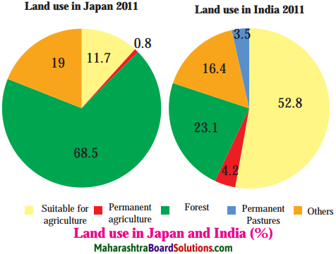
Study the Figure and answer the following questions:
Question A.
In which country is the land under forests more?
Answer:
The land under forests is more in Japan.
Question B.
In which country is the land under agriculture more?
Answer:
The land under agriculture is more in India.
![]()
Question C.
Considering the two questions above, how will you relate the physiography and climate of India and Japan with their respective land uses?
Answer:
Due to plains and monsoon climatic conditions, the population in India is more. Therefore, agricultural land use is prominent in India. Due to mountainous region and more proportion of precipitation, the forest land use is prominent in Japan.
Question D.
Correlate their land use and development.
Answer:
The land use in India shows comparatively low development. On the other hand, land use in Japan shows comparatively high development.
Question E.
Which land use is found in Japan?
Answer:
The land use like agricultural land use, forest land use, grassland land use, other land use, etc. are found in Japan.
Question F.
Considering the land use in both the countries, make a list of factors affecting land use.
Answer:
Considering the land use in both the countries, lists of factors affecting land use are as follows:
(a) Factors affecting land use in India:
- Fertility of soil
- Climatic conditions
- Natural resources
- Slope of land, etc.
(b) Factors affecting land use in Japan:
- Technical advancement
- Availability of resources
- Government policies, etc.
Can you tell?
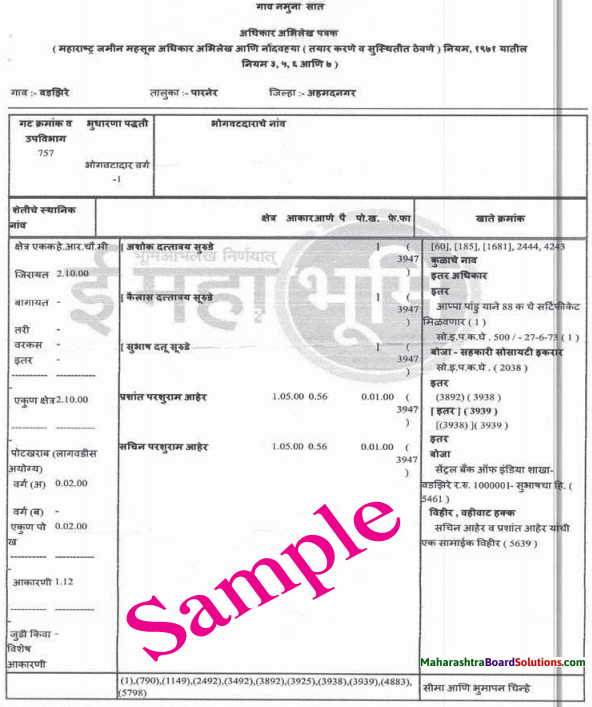
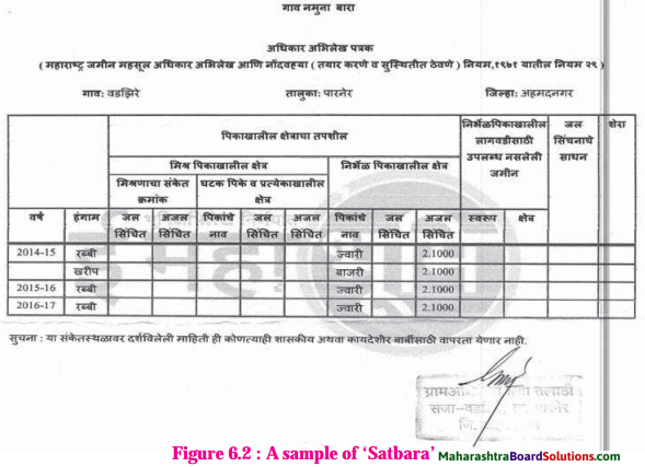
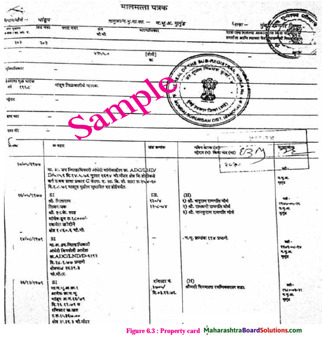
Study the Figure and answer the following questions:
Question A.
What kind of land use is shown in Figure 6.2 and 6.3?
Answer:
Land use shown in Figure 6.2 is agricultural land use and land use shown in Figure 6.3 is non-agricultural land use.
![]()
Question B.
Can you tell in which area the property is located?
Answer:
The property shown in Figure 6.2 is located in rural areas and the property shown in Figure 6.3 is located in urban areas.
Can you tell?
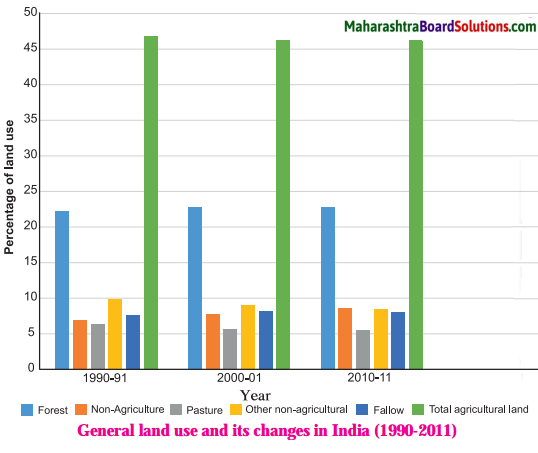
Study the Figure and answer the following questions:
Question A.
Which are the land uses of 1990-91 that show decline in 2010-11? What could be reasons for this?
Answer:
Total agricultural land use and other non-agricultural land use of 1990-91 show decline in 2010-11. Increased urbanisation could be reason for this.
Question B.
Which type of land use is the maximum? What would be the impact of this on India’s environment?
Answer:
Agricultural land use is the maximum. It indicates that India is an agrarian country and its environment is comparatively more natural.
![]()
Question C.
Can a decline in the area under agriculture equated with food shortage?
Answer:
A decline in the area under agriculture cannot be equated with food shortage. With modern technology, the maximum agricultural food production can be undertaken in limited areas.
Can you tell?
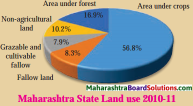
Study the figure and answer the following questions:
Question A.
What is the percentage of land suitable for cultivation?
Answer:
The percentage of land suitable for cultivation is 56.8.
Question B.
What is the percentage of barren land?
Answer:
The percentage of barren land is 8.3.
![]()
Question C.
What is the percentage of land under forest in Maharashtra?
Answer:
The percentage of land under forest in Maharashtra is 16.9.
Question D.
What is the percentage of non- agricultural land in Maharashtra?
Answer:
The percentage of non-agricultural land in Maharashtra is 10.2.
Give it a try.
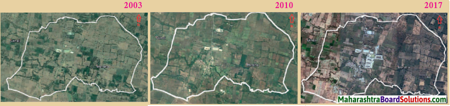
Study the Figure. It shows the satellite images of Mondha Village (Taluka – Hingna, District – Nagpur).
Question A.
Find out the changes in land use pattern over time and write a note.
Answer:
- The satellite image of Mondha Village in Hingna taluka in Nagpur district shows that agricultural land use in the village has declined from 2010 to 2017.
- The satellite image of Mondha Village in Hingna taluka in Nagpur district shows that residential land use in the village has increased from 2010 to 2017.
- Urbanisation, increasing population, etc. factors must be responsible for changes in land use pattern over time in Mondha Village.
Thought Provoking Question:
Think about it.
Question A.
If land is left fallow, or is not in use, then can it be termed as a kind of land use?
Answer:
1. The agricultural land which is temporarily not in use is called fallow land.
2. Fallow land use is a form of rural land use.
3. To increase the fertility of soil, farmers do not use a part of agricultural land for few seasons. After one or two seasons fallow land is again utilized for cultivation. Therefore, if land is left fallow, or is not in use, then it can be termed as a kind of land use.
![]()
Open-Ended Question:
Question A.
Write the advantages of planned cities in your own words.
Answer:
The advantages of planned cities are as follows:
- There will not be a problem of traffic jam in planned cities.
- The level of pollution will be the minimum in the planned cities.
- The planned cities will be clean and they will maintain environmental balance.
- The quality of human life will be superior in planned cities.